
Gößweinstein
| coat of arms | Germany map | |
|---|---|---|

|
Coordinates: 49 ° 46 ' N , 11 ° 20' E |
|
| Basic data | ||
| State : | Bavaria | |
| Administrative region : | Upper Franconia | |
| County : | Forchheim | |
| Height : | 457 m above sea level NHN | |
| Area : | 57.69 km 2 | |
| Residents: | 4044 (Dec. 31, 2019) | |
| Population density : | 70 inhabitants per km 2 | |
| Postal code : | 91327 | |
| Area code : | 09242 | |
| License plate : | FO, EBS , PEG | |
| Community key : | 09 4 74 129 | |
| Market structure: | 31 districts | |
Market administration address : |
Burgstrasse 8 91327 Gößweinstein |
|
| Website : | ||
| Mayor : | Hanngörg Zimmermann ( FW ) | |
| Location of the Gößweinstein market in the Forchheim district | ||
  |
||

Gößweinstein [pronounced: 'gœsvɐɪnʃtɐɪn ] is a market in the Upper Franconian district of Forchheim with around 4,000 inhabitants and is located in Franconian Switzerland above the confluence of Wiesent , Ailsbach and Püttlach near Behringersmühle . The castle and the pilgrimage basilica , built according to plans by Balthasar Neumann , are striking .
geography
Geographical location

Gößweinstein is located in the heart of Franconian Switzerland , in the middle of the city triangle Bamberg , Bayreuth and Nuremberg
Neighboring communities
Neighboring communities are (starting from the north clockwise) Waischenfeld , Ahorntal , Pottenstein , Obertrubach , Egloffstein , Pretzfeld , Ebermannstadt and Wiesenttal .
Community structure
Gößweinstein has 32 districts :
history
Until the 19th century
The castle "Goswinesteyn" was first mentioned in 1076. Before 1102 the castle fell to the bishopric of Bamberg and from 1348 to 1780 was the seat of a bailiff of the bishops of Bamberg . In the first half of the 15th century the castle and the office of Gößweinstein was pledged to Hans, then to Paul von Streitberg. The von Streitbergs had owned the Gößweinsteiner tithe as an imperial fief since the Middle Ages.
In 1525 there was destruction during the Peasants' War and subsequent reconstruction. In the Second Margrave War in 1553, Gößweinstein was destroyed again and rebuilt. The Bamberg prince-bishop Friedrich Carl von Schönborn (ruled from 1729 to 1746) raised Gößweinstein to the market. During the secularization of 1803, the area of the Bamberg monastery came to Bavaria.
District affiliation
On July 1, 1972, Gößweinstein came from the dissolved Pegnitz district to the Forchheim district.
Incorporations
As part of the regional reform in Bavaria , the formerly independent communities of Behringersmühle, Kleingesee, Stadelhofen, Unterailsfeld and part of the dissolved community of Tüchersfeld (Hühnerloh and Kohlstein) were incorporated into the Gößweinstein market on January 1, 1972. Leutzdorf was added on January 1, 1974. Morschreuth and, from the dissolved municipality of Wichsenstein, the places Wichsenstein, Altenthal, Hardt, Sattelmannsburg and Ühleinshof followed on May 1, 1978.
politics
mayor
Hanngörg Zimmermann has been the mayor of the township of Gößweinstein since 2014. The predecessor was Georg Lang (CSU).
Market council
The market town council of Gößweinstein has 16 members plus the full-time mayor.
| CSU | SPD | Free voters | Youth and women | Civic community | Civic Association of the market town of Gößweinstein | total | |
| 2008 | 5 | 3 | 4th | 2 | 2 | 0 | 16 seats |
| 2014 | 5 | 3 | 3 | 2 | 1 | 2 | 16 seats |
| 2020 | 4th | 3 | 4th | 2 | - | 3 | 16 seats |
(Status: local election on March 15, 2020)
coat of arms
|
|
Blazon : "In gold on a green three-hill on a red pole, a green vine with two blue grapes and two green leaves."
The coat of arms has been documented for Gößweinstein since the 17th century. |
After the regional reform in 1978, the municipal council decided to take over the historic coat of arms of Gößweinstein unchanged.
Economy and Infrastructure
Transportation
The entire market area of Gößweinstein belongs to the Verkehrsverbund Großraum Nürnberg GmbH (abbreviated: VGN) . There are several regular bus connections to the surrounding towns and cities.
railroad
The Gößweinstein market is on the Forchheim – Behringersmühle railway line . While the section from Forchheim to Ebermannstadt continues to be served by trains from agilis Verkehrsgesellschaft mbH , the section Ebermannstadt to Behringersmühle was closed for passenger traffic on May 30, 1976 by the Deutsche Bundesbahn . However, the Franconian Switzerland Steam Railway operates a museum, especially in the summer months. The Gößweinstein train stations and the Behringersmühle terminal, which is also part of the Gößweinstein market, are on the route. Originally, after 1930, the line from the Behringersmühle station in the direction of Pottenstein or even as far as Pegnitz was to be continued to connect to the main line from Nuremberg to Bayreuth. This project could no longer be implemented due to the onset of the global economic crisis and the later growing importance of road traffic. The next regularly served train station stops are Ebermannstadt, from where there are hourly connections to Forchheim , Graefenberg with hourly trains to Nuremberg-Nordost and Pegnitz train station with hourly connections to Bayreuth and Nuremberg. The nearest stations of the Nuremberg S-Bahn are in Forchheim and Kersbach .
Road traffic
Several state roads ensure the connection to the surrounding towns and cities. The Gößweinstein market itself is easily accessible from several streets. The next federal road, the B 470 , leads through the district of Behringersmühle. The closest federal motorways are the A 73 in the direction of Bamberg and Erlangen and the A 9 in the direction of Bayreuth and Nuremberg.
Hiking trails
The Franconian Marienweg runs through Gößweinstein .
Culture and sport
Gößweinstein is located in Franconian Switzerland above the Wiesent valley. The market is located in the middle of the Northern Franconian Jura climbing area , and numerous hiking and cycling trails are also located in the city.
Attractions

Museums
- Pilgrimage Museum Gößweinstein
- Local history collection in the guest house
- Franconian Switzerland Steam Railway (Museum Railway)
Buildings


- The pilgrimage church of the Holy Trinity with Franciscan monastery was built between 1730 and 1739 under Prince-Bishop Friedrich Carl von Schönborn according to plans by Balthasar Neumann , who also supervised the construction himself. The church was in 1948 at the request of the Franciscan Father Luchesius Spätling by Pope Pius XII. raised to the papal basilica minor .
- Gößweinstein Castle
- Viktor von Scheffel Monument, on which the verses from the poem Exit can be read on both sides :
- “I'm going into the world! My hat decoration the rose, my bed in the moss, the sky my tent.
May mourn and lurk, whoever wants, behind walls - I'm going into the world! "
See also: List of architectural monuments in Gößweinstein
Viewpoints

There are several viewpoints around the place. These include:
- the Gernerfels, the Kreuzberg with Hochkreuz, the Martinswand and Bellevue, the pavilion on the Wagnershöhe
- the Ludwigshöhe (theater cave), the Bärenstein (529 m above sea level), the Fischersruh, the Nuremberg Chapel
- the lookout rock at Wichsenstein (585 m above sea level)
Recreational facilities
- Gößweinstein natural outdoor pool
- Gößweinstein mini golf course
- 3-D archery course
- Kayak and boat rental
- Kneipp facilities in the spa gardens and in Behringersmühle
- 250 km of marked hiking trails
- Balthasar Neumann circular hiking trail
- Riding stables
- Bike rental station
- Eibenwald natural forest reserve
- Morschreuth creative center
- Free chess in Behringersmühle
- Water adventure place in Behringersmühle
- Football ground in Behringersmühle
flora
The Gößweinsteiner whitebeam ( Sorbus pulchra ) occurs as an endemic whitebeam species exclusively in Gößweinstein and its immediate surroundings. Like the Hersbruck whitebeam ( Sorbus pseudothuringiaca ), it is one of the endangered species in Germany.
North of Gößweinstein on the northern slope of the Wiesenttal there is a beautiful population of yew trees , under beeches . The area was designated as a natural forest reserve on 32 hectares and has been a nature reserve since 1982 .
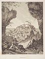
Historical illustrations

View from the northwest over the Wiesent valley to Gößweinstein, steel engraving (1834) by Conrad Wießner
Gößweinstein Castle, lithograph (around 1840) by Theodor Rothbarth after a drawing by Carl Käppel

Gößweinstein Castle, Zur Post inn in Behringersmühle and Gößweinstein Basilica, postcard (1895)

Gößweinstein Castle and Basilica, 1928/29


literature
- Franz X. Bogner: Franconian Switzerland. An aerial portrait. Ellwanger Verlag, Bayreuth 2007, pp. 50–54; ISBN 978-3-925361-62-3 .
- Johann Kaspar Bundschuh : Gößweinstein . In: Geographical Statistical-Topographical Lexicon of Franconia . tape 2 : El-H . Verlag der Stettinische Buchhandlung, Ulm 1800, DNB 790364298 , OCLC 833753081 , Sp. 354 ( digitized version ).
- Pleikard Joseph Stumpf : Gößweinstein . In: Bavaria: a geographical-statistical-historical handbook of the kingdom; for the Bavarian people . Second part. Munich 1853, p. 623-624 ( digitized version ).
Web links
- Gößweinstein and Behringersmühle
- Foracheim: pilgrimage basilica in Gößweinstein
- Gößweinstein: Official statistics of the LfStat
- Aerial photos of the pilgrimage site
Individual evidence
- ↑ "Data 2" sheet, Statistical Report A1200C 202041 Population of the municipalities, districts and administrative districts 1st quarter 2020 (population based on the 2011 census) ( help ).
- ^ Community Gößweinstein in the local database of the Bavarian State Library Online . Bayerische Staatsbibliothek, accessed on May 24, 2020.
- ^ Dieter Zöberlein: The von Streitberg, story of a Franconian noble family. Self-published, Burggrub 2018.
- ^ Wilhelm Volkert (ed.): Handbook of Bavarian offices, communities and courts 1799–1980 . CH Beck, Munich 1983, ISBN 3-406-09669-7 , p. 549 .
- ^ Federal Statistical Office (ed.): Historical municipality directory for the Federal Republic of Germany. Name, border and key number changes in municipalities, counties and administrative districts from May 27, 1970 to December 31, 1982 . W. Kohlhammer, Stuttgart / Mainz 1983, ISBN 3-17-003263-1 , p. 683 .
- ^ Administration> Section I - First Mayor. Community of Gößweinstein, accessed on August 2, 2020 .
- ↑ Entry on the coat of arms of Gößweinstein in the database of the House of Bavarian History
- ^ Norbert Meyer: Profiles on the vascular plants of Bavaria, Sorbus pulchra N. Mey. Botanical State Collection Munich, accessed on June 3, 2014 .
- ↑ Maps of the protected areas of the Federal Agency for Nature Conservation

Dormitz | Ebermannstadt | Effeltrich | Eggolsheim | Egloffstein | Forchheim | Gößweinstein | Graefenberg | Hallerndorf | Hausen | Heroldsbach | Hetzles | Hiltpoltstein | Igensdorf | Kirchehrenbach | Kleinsendelbach | Kunreuth | Langensendelbach | People Bach | Neunkirchen am Brand | Obertrubach | Pinzberg | Poxdorf | Pretzfeld | Lower ladder | Weilersbach | Weißenohe | Wiesenthau | Wiesenttal
Allersdorf | Altenthal | Behringersmühle | Bösebirkig | Etzdorf | Hostage height | Gößweinstein | Hardt | Hartenreuth | Chicken tease | Hungenberg | Small lake | Kohlstein | Leimersberg | Leutzdorf | Liebenau | Moritz | Morschreuth | Mosque village | Prügeldorf | Sachsendorf | Sachsenmühle | Sattelmannsburg | Schweigelberg | Stadelhofen | Stamp mill | Türkelstein | Ühleinshof | Sub-tail field | Wichsenstein | Wölm