Poxdorf (Upper Franconia)
| coat of arms | Germany map | |
|---|---|---|

|
Coordinates: 49 ° 40 ' N , 11 ° 4' E |
|
| Basic data | ||
| State : | Bavaria | |
| Administrative region : | Upper Franconia | |
| County : | Forchheim | |
| Management Community : | Effeltrich | |
| Height : | 278 m above sea level NHN | |
| Area : | 5.17 km 2 | |
| Residents: | 1494 (Dec. 31, 2019) | |
| Population density : | 289 inhabitants per km 2 | |
| Postal code : | 91099 | |
| Area code : | 09133 | |
| License plate : | FO, EBS , PEG | |
| Community key : | 09 4 74 160 | |
| Community structure: | 1 district | |
| Address of the municipal administration: |
Hauptstrasse 12 91099 Poxdorf |
|
| Website : | ||
| First Mayor : | Paul Steins ( CSU ) | |
| Location of the municipality of Poxdorf in the Forchheim district | ||
Poxdorf is a municipality in the Forchheim district ( Upper Franconia administrative district ) and a member of the Effeltrich administrative community . Poxdorf is mainly a residential community, but also has agriculture and commerce. The connection to the federal motorway 73 is 1.5 km away . The next train station Baiersdorf can be reached by bus.
geography
The municipality of Poxdorf is located in the Regnitz Valley on the edge of Franconian Switzerland between the cities of Erlangen and Forchheim, about seven kilometers south-east of Forchheim. The municipality of Poxdorf has no other districts . Neighboring communities are (starting from the north clockwise): Forchheim , Effeltrich , Langensendelbach , Baiersdorf . Poxdorf forms the administrative association Effeltrich with the municipality of Effeltrich. The Franconian Marienweg runs through the village .
history
The settlement of Poxdorf is likely to have taken place with the development and settlement of the Forchheim / Nuremberg Forest between 1007 and 1062 or around 1150. From the late Middle Ages until the secularization, Poxdorf belonged to the bishopric of Bamberg and from 1500 also to the Franconian Empire . Since the Reichsdeputationshauptschluss of 1803 the place belongs to Bavaria. In the course of the administrative reforms in Bavaria , today's municipality was created with the municipal edict of 1818 .
On May 1, 1978, the former district of Hagenau with around 600 inhabitants was ceded to the city of Baiersdorf in the Erlangen-Höchstadt district .
religion
The residents are 85% Catholic, 10% Protestant and 5% have any other or no creed. Poxdorf is the seat of a Catholic parish, Mary Sacrifice. Evangelical Christians are looked after by the Evangelical Lutheran parish of Baiersdorf.
politics
mayor
Paul Steins (CSU) has been mayor since 2014. His predecessor was Gunhild Wiegner (Free Voters).
Municipal council
The past local elections resulted in the following allocation of seats in the local council:
| CSU | SPD / ecologists | Free voters | Young citizens | total | |
| 2002 | 5 | 2 | 4th | 1 | 12 seats |
| 2008 | 4th | 2 | 4th | 2 | 12 seats |
| 2014 | 5 | 2 | 3 | 2 | 12 seats |
| 2020 | 5 | 2 | 2 | 3 | 12 seats |
coat of arms
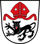
The description of the coat of arms reads: "In silver above a floating red miter, below a striding, looking, red-tongued black lion".
Culture and sights
- Parish Church of the Sacrifice of Mary Poxdorf
- Dorfkirchweih on the Sunday after August 15th
- Corpus Christi procession (corridor)
literature
- Johann Kaspar Bundschuh : Bocksdorf . In: Geographical Statistical-Topographical Lexicon of Franconia . tape 1 : A-egg . Verlag der Stettinische Buchhandlung, Ulm 1799, DNB 790364298 , OCLC 833753073 , Sp. 422 ( digitized version ).
- Johann Kaspar Bundschuh : Boxing village . In: Geographical Statistical-Topographical Lexicon of Franconia . tape 1 : A-egg . Verlag der Stettinische Buchhandlung, Ulm 1799, DNB 790364298 , OCLC 833753073 , Sp. 430 ( digitized version ).
- Johann Kaspar Bundschuh : Poxdorf . In: Geographical Statistical-Topographical Lexicon of Franconia . tape 4 : Ni-R . Verlag der Stettinische Buchhandlung, Ulm 1801, DNB 790364301 , OCLC 833753101 , Sp. 389 ( digitized version ).
Web links
- Official website of the municipality of Poxdorf
- Entry on the coat of arms of Poxdorf (Upper Franconia) in the database of the House of Bavarian History
Individual evidence
- ↑ "Data 2" sheet, Statistical Report A1200C 202041 Population of the municipalities, districts and administrative districts 1st quarter 2020 (population based on the 2011 census) ( help ).
- ^ Community Poxdorf in the local database of the Bavarian State Library Online . Bayerische Staatsbibliothek, accessed on January 4, 2020.
- ^ Federal Statistical Office (ed.): Historical municipality directory for the Federal Republic of Germany. Name, border and key number changes in municipalities, counties and administrative districts from May 27, 1970 to December 31, 1982 . W. Kohlhammer, Stuttgart / Mainz 1983, ISBN 3-17-003263-1 , p. 684 .


