
Obertrubach
| coat of arms | Germany map | |
|---|---|---|

|
Coordinates: 49 ° 42 ' N , 11 ° 21' E |
|
| Basic data | ||
| State : | Bavaria | |
| Administrative region : | Upper Franconia | |
| County : | Forchheim | |
| Height : | 434 m above sea level NHN | |
| Area : | 21.14 km 2 | |
| Residents: | 2211 (Dec. 31, 2019) | |
| Population density : | 105 inhabitants per km 2 | |
| Postal code : | 91286 | |
| Area code : | 09245 | |
| License plate : | FO, EBS , PEG | |
| Community key : | 09 4 74 156 | |
| Community structure: | 16 parts of the community | |
| Address of the municipal administration: |
Teichstrasse 5 91286 Obertrubach, Germany |
|
| Website : | ||
| Mayor : | Markus Grüner ( CSU ) | |
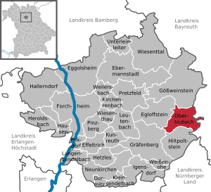
| Location of the municipality of Obertrubach in the Forchheim district | ||
  |
||


.jpg)
Obertrubach is a municipality in the Forchheim district ( Upper Franconia administrative district ).
geography
Geographical location
The community is located in the Franconian Switzerland-Veldenstein Forest Nature Park and, like many other places in Franconian Switzerland, is of touristic importance (880 guest beds). The Trubach rises in Obertrubach .
Neighboring communities
Neighboring communities are (starting from the north clockwise): Gößweinstein , Pottenstein , Betzenstein , Hiltpoltstein , Graefenberg , Egloffstein .
Community structure
The municipality of Obertrubach has 16 parts of the municipality (in brackets, the number of inhabitants and the amount, if applicable):
|
|
history
First mention
The first documentary mention was in the year 1007 in connection with the establishment of the diocese of Bamberg . The new diocese gave King Henry II. On November 1, 1007 the old royal court Vorchheim ( Forchheim ) in Radenzgau with all accessories for miles around and all hearing Forchheim like "Truobaha" (Trubach) and "Tuoisbrunno" ( Thuisbrunn ). Before that there is only scant news from the time of Charlemagne (786–814). In 794, the names of the places "Trobach" and "Herzewin" (Herzogwind) appeared for the first time. Obertrubach has a history that goes back over a thousand years.
religion
Obertrubach is the parish of the Catholic parish of St. Laurentius Obertrubach. There you will find the parish church of the same name and the Catholic meeting place St. Elisabeth . The following branch churches belong to the parish of Obertrubach:
- Bärnfels, Maria-Schnee-Kirche
- Geschwand, Assumption
- Untertrubach, St. Felicitas
Incorporations
On January 1, 1972, what was then the community of Wolfsberg with Untertrubach, Dörfles, Sorg and Hundsdorf joined the community of Obertrubach. In the course of the territorial reform, the former municipalities Bärnfels (with Galgenberg), which was created on January 1, 1953 by outsourcing from Kleingesee, and Geschwand (with Linden), which was called Gschwand until 1875, as well as the place Haselstauden, became the incorporated into the dissolved municipality of Thuisbrunn.
Outsourcing
On May 1, 1978, the Möchs part of the municipality with more than 50 inhabitants was spun off in the Hiltpoltstein market.
Temporary meeting place for neo-Nazis
In the media there were reports about neo-Nazi events such as celebrations and concerts in the Geschwand district of Obertrubach for several years until the last time in 2011 . The meadow used for the events was auctioned in 2006 by the wife of an activist of the Franconian Action Front , which was banned in 2004 . Politicians from the NPD and the band The Lunikoff Conspiracy took part in the events.
The community of Obertrubach initially tried, unlike the community of Graefenberg , a few kilometers away , which fought against neo-Nazi marches with numerous actions, to ignore the events. At the end of July 2010, the mayor of Obertrubach announced in a discussion forum that he would take action against the neo-Nazi events. Another neo-Nazi concert took place in Geschwand in May 2011, and the 2011 Frankentag was moved to Roden by the organizers . An "entertainment festival" registered for June 2, 2012 by a management member of Freie Netz Süd was prevented by the community by refusing a special permit for the dirt road leading to the meadow, which was only released for agricultural vehicles. The access ban was confirmed by the Bayreuth Administrative Court following a complaint by the organizer .
politics
mayor
Markus Grüner (CSU) has been mayor since 2014. His predecessors were Willi Müller (CSU) and Johann Albert (CSU).
Municipal council
The local elections in 2002, 2008, 2014 and 2020 led to the following allocation of seats in the local council:
| CSU | Citizens Union |
Active citizen list Geschwand |
Independent group of voters |
Young citizens |
Free voter community Obertrubach |
Herzogwind village community |
Citizens Workshop community Obertrubach |
total | |
|---|---|---|---|---|---|---|---|---|---|
| 2002 | 6th | 2 | 2 | 1 | 1 | 1 | 1 | - | 14 seats |
| 2008 | 5 | 3 | 2 | 1 | 1 | 1 | 1 | - | 14 seats |
| 2014 | 4th | 2 | 2 | 1 | 1 | 1 | 1 | 2 | 14 seats |
| 2020 | 3 | 3 | 2 | 1 | 1 | 1 | 1 | 2 | 14 seats |
coat of arms
In 1972 the formerly independent communities of Obertrubach and Wolfsberg were merged under the name Obertrubach. The municipal council decided to adopt the Wolfsberg coat of arms unchanged for the new municipality. It has been in operation since July 25, 1973.
The description of the coat of arms reads: "In gold on a silver three-mountain a growing, two-towered, tinned, black castle ruin with a central breach, in it elevated by a red- tongued black wolf's hull ."
Declaration of the coat of arms: The Dreiberg represents the location of the municipality in Franconian Switzerland and stands at the same time as the Wolfsrumpf for the place name Wolfsberg. The black castle ruins represent Wolfsberg Castle from the 12th century, as a reminder of the historical significance in the Bamberg Monastery . Around 1333 the castle came to the Lords of Egloffstein , which is reminiscent of the colors gold and black.
Sights and culture
Castles
Churches

- Parish Church of St. Laurentius, Obertrubach
- Filial church St. Felicitas, the first church in Untertrubach
- Maria Schnee branch church, Bärnfels
- Filial church of the Assumption of Mary, Geschwand
regional customs
- Annual resolution of eternal adoration on January 3rd with the burning of the mountain fires.
nature
- Signal stone at Geschwand
sport and freetime

The community is located in the middle of the Northern Franconian Jura climbing area , numerous hiking and cycling trails such as the Frankenweg lead through the community area.
The climbing information center Franconian Switzerland was set up at the gates of the community and not far from the overhanging wall of the famous "Eldorado". It is intended to draw attention to the importance of the region for the development of climbing and to give Franconian Switzerland even more attention. The region in the triangle between Forchheim, Bamberg and Bayreuth is one of Germany's most important climbing regions. The Franconian Jura covers 2300 square kilometers with around 1000 rocks and 12,000 individual routes. The aim of the approximately 2000 square meter information center is to provide interested visitors, active athletes, newcomers and families with children with everything they need to know about climbing. This concerns the climbing area Frankenjura, climbing techniques and the flora around the climbing rocks. Under a pavilion, the more than one hundred year old tradition of climbing, historical and current techniques, safety aspects and nature and environmental issues are discussed on six movable walls with numerous photos, graphics and explanatory text.
traffic
Obertrubach is located on federal highway 2 and can be reached via federal highway 9 .
Others

The climber Wolfgang Güllich is buried in the cemetery of the parish church of St. Laurentius. His natural tombstone is visited by sport climbers from all over the world and decorated with pieces of rope and other climbing equipment.
literature
- Johann Kaspar Bundschuh : Obertruppach . In: Geographical Statistical-Topographical Lexicon of Franconia . tape 4 : Ni-R . Verlag der Stettinische Buchhandlung, Ulm 1801, DNB 790364301 , OCLC 833753101 , Sp. 230-231 ( digitized version ).
- Norbert Haas: Obertrubach, a local history study . Burgebrach 1988
Web links
- Official homepage
- 1000 years of Obertrubach and Untertrubach ( Memento from October 2, 2012 in the Internet Archive )
- Local history and churches of Ober- and Untertrubach near Foracheim
- Entry on the coat of arms of Obertrubach in the database of the House of Bavarian History
- Obertrubach: Official statistics of the LfStat
- Obertrubach : procession of lights
- http://www.klettern.frankenjura.com/deutsch/news_artikel.php3?name=eroeffnung_kiz_obertrubach_213
Individual evidence
- ↑ "Data 2" sheet, Statistical Report A1200C 202041 Population of the municipalities, districts and administrative districts 1st quarter 2020 (population based on the 2011 census) ( help ).
- ^ Obertrubach community in the local database of the Bayerische Landesbibliothek Online . Bayerische Staatsbibliothek, accessed on January 4, 2020.
- ^ Wilhelm Volkert (ed.): Handbook of Bavarian offices, communities and courts 1799–1980 . CH Beck, Munich 1983, ISBN 3-406-09669-7 , p. 540 .
- ↑ a b Federal Statistical Office (ed.): Historical municipality register for the Federal Republic of Germany. Name, border and key number changes in municipalities, counties and administrative districts from May 27, 1970 to December 31, 1982 . W. Kohlhammer, Stuttgart / Mainz 1983, ISBN 3-17-003263-1 , p. 684 .
- ↑ a b Obertrubach / Geschwand: Another neo-Nazi concert on the Nazi meadow in May 2011 on nazistopp-nuernberg.de; Retrieved June 19, 2011
- ↑ http://www.infranken.de/regional/forchheim/Nazis-auch-in-Forchheim;art216,225450
- ↑ http://www.main-echo.de/ueberregional/politik/art20492,1894818
- ↑ http://www.br.de/nachrichten/oberfranken/inhalt/obertrubach-hotel-asylunterkunft-100.html ( Memento from May 12, 2015 in the Internet Archive )
- ↑ Do neo-Nazis celebrate unmolested near Obertrubach? , Nürnberger Nachrichten of July 2, 2009; Retrieved June 19, 2011
- ↑ Obertrubach starts offensive against neo-Nazis , Nordbayerischer Kurier from August 1, 2010; Retrieved June 19, 2011
- ↑ Results of the local elections of March 16, 2014 , accessed on April 3, 2014
- ↑ Festival of Lights, press report and photos 2015 , accessed on January 13, 2015
Bärnfels | Dörfles | Geschwand | Chopper mill | Hazel trees | Duke wind | Hundsdorf | Linden | Neudorf | Obertrubach | Reichelsmühle | Schlöttermühle | Sorg | Untertrubach | Wolfsberg | Brick mill

Dormitz | Ebermannstadt | Effeltrich | Eggolsheim | Egloffstein | Forchheim | Gößweinstein | Graefenberg | Hallerndorf | Hausen | Heroldsbach | Hetzles | Hiltpoltstein | Igensdorf | Kirchehrenbach | Kleinsendelbach | Kunreuth | Langensendelbach | People Bach | Neunkirchen am Brand | Obertrubach | Pinzberg | Poxdorf | Pretzfeld | Lower ladder | Weilersbach | Weißenohe | Wiesenthau | Wiesenttal