
Igensdorf
| coat of arms | Germany map | |
|---|---|---|

|
Coordinates: 49 ° 37 ' N , 11 ° 14' E |
|
| Basic data | ||
| State : | Bavaria | |
| Administrative region : | Upper Franconia | |
| County : | Forchheim | |
| Height : | 336 m above sea level NHN | |
| Area : | 28.83 km 2 | |
| Residents: | 5084 (Dec. 31, 2019) | |
| Population density : | 176 inhabitants per km 2 | |
| Postal code : | 91338 | |
| Primaries : | 09192, 09126 | |
| License plate : | FO, EBS , PEG | |
| Community key : | 09 4 74 140 | |
| LOCODE : | DE IGD | |
| Market structure: | 25 districts | |
Market administration address : |
Forchheimer Strasse 7 91338 Igensdorf |
|
| Website : | ||
| Mayor : | Edmund Ulm ( CSU ) | |
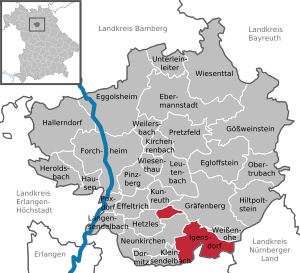
| Location of the Igensdorf market in the Forchheim district | ||
  |
||

Igensdorf is a market in the Upper Franconian district of Forchheim .
geography
Geographical location
The municipality of Igensdorf is located in the Franconian Alb on the southwestern edge of the Franconian Switzerland-Veldenstein Forest Nature Park and is characterized by the floodplains of the Schwabach , the Lillach and the Rüsselbach. The highest elevations are the Hetzleser Berg ( 549 m above sea level ), the Eberhardsberg ( 533.5 m above sea level ) with the Teufelstisch natural monument and the Küheberg ( 521 m above sea level ) with the western mountain spur Mitteldorfer Berg ( 507 m above sea level) . NHN and the Burgstall Hainburg ). The lowest point is the area around the Obere Schwabach sewage treatment plant at around 314 m above sea level. NHN .
Neighboring communities
Neighboring communities are Graefenberg , Weißenohe , Schnaittach , Eckental , Kleinsendelbach , Neunkirchen am Brand , Hetzles and Kunreuth, starting from the north and moving clockwise .
Community structure
The market Igensdorf has 25 districts :
climate
Due to the favorable climatic location, Igensdorf is in one of the largest cherry growing areas in Germany.
history
Until the 19th century
On April 14, 1109, Igensdorf was mentioned for the first time as "Diedungsdorf", probably named after a tribal leader named Dieto, in the confirmation bull regarding the foundation of the Weißenohe monastery , issued by Pope Paschal II . From the beginning of the 16th to the beginning of the 19th century it belonged to the Hiltpoltstein nursing office in Nuremberg . On January 30, 1804, Igensdorf became Prussian because it was added to the Prussian base in Baiersdorf . With the Rheinbund act in 1806, the place became part of Bavaria. Igensdorf briefly became Austrian in 1809, then French until 1811, when it came to Graefenberg and thus became Bavarian again.
Formation of the new community of Igensdorf
On January 1, 1972, the previously independent municipalities of Dachstadt, Pettensiedel, Rüsselbach and Stöckach were incorporated into the newly formed municipality of Igensdorf as part of the municipal reform. Only Frohnhof was assigned to the Eckental market from June 1, 1972 on the basis of a vote . Originally the community of Igensdorf was to be assigned to the administrative community of Graefenberg. The local council did not see a citizen-friendly solution in this project, especially since decisive administrative tasks were performed in Graefenberg and the citizens felt compelled to travel there in order to have their concerns processed. With the argument that a community of around 3,000 inhabitants is not too small to be able to work properly, the community representatives sought renewed independence and achieved this on January 1, 1980. This was celebrated with an ecumenical service.
The granting of market rights for the municipality of Igensdorf on August 23, 1980 marked the end of this development.
Incorporations
On January 1, 1975, the previously independent municipality of Pommer was incorporated.

politics
Market council
The municipal council of Igensdorf had 16 members from 2014 to 2020 plus the mayor. In the local elections on March 16, 2014 , the following distribution of seats resulted:
| CSU | Igensdorf area | SPD | Free group of voters | Young citizens | Green | Citizens Union Igensdorf (BUI) | total |
| 3 | 6th | 2 | 1 | 1 | 2 | 1 | 16 seats |
The municipal council has 20 members plus the mayor in the 2020 to 2026 electoral period. In the local elections on March 15, 2020, the distribution of seats was as follows:
| CSU | Igensdorf area | SPD | Free group of voters | Young citizens | Green | FDP | total |
| 6th | 6th | 2 | 2 | 1 | 3 | 0 | 20 seats |
mayor
| Term of office | Surname | Political party |
| 1972-2008 | Erwin H. Zeiss | CSU |
| 2008-2020 | Wolfgang Rast | Igensdorf area |
| since 2020 | Edmund Ulm | CSU |
Erwin H. Zeiß was made an honorary citizen of the Igensdorf market on January 11, 2009.
coat of arms
|
|
Blazon : “Under a red shield head, inside a continuous silver bar cross, split; in front in gold a half black eagle at the gap, behind in silver two red cherries on a branch with two leaves. " |
Town twinning

On September 26, 1992, the partnership between the municipality of Saint-Martin-la-Plaine and the Igensdorf market was concluded in a ceremony . Since then there have been lively contacts in the fields of culture, club life and student and youth exchanges.
St. Martin la Plaine is about 25 kilometers southwest of Lyon and has about 3500 inhabitants. Its area is about 970 hectares. The average altitude is 430 meters above sea level. The area around St. Martin la Plaine is characterized by agricultural use, fruit growing and viticulture. The partner community has a long tradition in blacksmithing. Today most of the workshops are closed, they are only engaged in ironwork.
Culture and sights

The community is responsible for a singing and music school . Every year the Igensdorf cultural summer takes place with numerous concerts with predominantly classical music.
Some artists have settled in the districts of Oberrüsselbach and Pettensiedel. The St. George's Church, built in 1687 and renovated in 2006, is worth seeing, especially its furnishings .
The sun and planet path was newly laid out . The distances between the individual planets and the sun are shown on a reduced scale. The elements were designed by the artist Dieter Erhard.
traffic
The community is located on Bundesstraße 2 and the Graefenbergbahn (R21). In Igensdorf, the state road 2236 branches off to Forchheim. There are train stations in Weidenbühl (Rüsselbach train station), Igensdorf and Weißenohe.
literature
- Johann Kaspar Bundschuh : Igensdorf . In: Geographical Statistical-Topographical Lexicon of Franconia . tape 3 : I-Ne . Verlag der Stettinische Buchhandlung, Ulm 1801, DNB 790364301 , OCLC 833753092 , Sp. 10–11 ( digitized version ).
Web links
- Local government
- Partner community St. Martin la Plaine
- Igensdorf: Official statistics of the LfStat
Individual evidence
- ↑ "Data 2" sheet, Statistical Report A1200C 202041 Population of the municipalities, districts and administrative districts 1st quarter 2020 (population based on the 2011 census) ( help ).
- ^ Community Igensdorf in the local database of the Bavarian State Library Online . Bayerische Staatsbibliothek, accessed on January 4, 2020.
- ^ Wilhelm Volkert (ed.): Handbook of Bavarian offices, communities and courts 1799–1980 . CH Beck, Munich 1983, ISBN 3-406-09669-7 , p. 462 .
- ^ Federal Statistical Office (ed.): Historical municipality directory for the Federal Republic of Germany. Name, border and key number changes in municipalities, counties and administrative districts from May 27, 1970 to December 31, 1982 . W. Kohlhammer, Stuttgart / Mainz 1983, ISBN 3-17-003263-1 , p. 685 .
- ^ Federal Statistical Office (ed.): Historical municipality directory for the Federal Republic of Germany. Name, border and key number changes in municipalities, counties and administrative districts from May 27, 1970 to December 31, 1982 . W. Kohlhammer, Stuttgart / Mainz 1983, ISBN 3-17-003263-1 , p. 683 .
- ^ Election result Igensdorf 2020. Accessed on May 4, 2020 .
- ↑ Runoff 2020. Accessed May 4, 2020 .
- ↑ Municipal Council 2020-2026. Igensdorf municipality, accessed on 23 August 2020 .
- ^ Entry on the coat of arms of Igensdorf in the database of the House of Bavarian History

Dormitz | Ebermannstadt | Effeltrich | Eggolsheim | Egloffstein | Forchheim | Gößweinstein | Graefenberg | Hallerndorf | Hausen | Heroldsbach | Hetzles | Hiltpoltstein | Igensdorf | Kirchehrenbach | Kleinsendelbach | Kunreuth | Langensendelbach | People Bach | Neunkirchen am Brand | Obertrubach | Pinzberg | Poxdorf | Pretzfeld | Lower ladder | Weilersbach | Weißenohe | Wiesenthau | Wiesenttal
Affalterbach | Ground pit | Bremenhof | Roof city | Oak mill | Etlas wind | Haselhof | Igensdorf | Kirchrüsselbach | Latvians | Lettenmühle | Lindenhof | Lindenmühle | Mitteldorf | Mittelrüsselbach | Neusleshof | Oberlindelbach | Unterlindelbach | Oberrüsselbach | Pettensiedel | Pommer | Stöckach | Unterrüsselbach | Weidenbühl | Willow mill