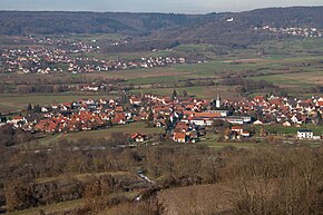
Kirchehrenbach
| coat of arms | Germany map | |
|---|---|---|

|
Coordinates: 49 ° 44 ' N , 11 ° 9' E |
|
| Basic data | ||
| State : | Bavaria | |
| Administrative region : | Upper Franconia | |
| County : | Forchheim | |
| Management Community : | Kirchehrenbach | |
| Height : | 282 m above sea level NHN | |
| Area : | 8.24 km 2 | |
| Residents: | 2208 (Dec. 31, 2019) | |
| Population density : | 268 inhabitants per km 2 | |
| Postal code : | 91356 | |
| Area code : | 09191 | |
| License plate : | FO, EBS , PEG | |
| Community key : | 09 4 74 143 | |
| LOCODE : | DE KEC | |
| Community structure: | 2 districts | |
| Address of the municipal administration: |
Hauptstrasse 53 91356 Kirchehrenbach |
|
| Website : | ||
| Mayoress : | Anja Gebhardt ( SPD ) | |
| Location of the municipality of Kirchehrenbach in the Forchheim district | ||
Kirchehrenbach is a municipality in the Upper Franconian district of Forchheim and the seat of the Kirchehrenbach administrative community .
geography
Geographical location
The place is in Franconian Switzerland at the foot of the Ehrenbürg , ( Walberla ) on the Ehrenbach, which gives it its name .
Community structure
The municipality of Kirchehrenbach has 2 districts :
- Kirchehrenbach
- St. Walpurgis
Neighboring communities
Neighboring communities are (starting from the north clockwise): Pretzfeld , Leutenbach , Wiesenthau , Forchheim , Weilersbach .
history
The place was first mentioned in a document in 1089 as Arinbach. Until 1803, Kirchehrenbach belonged to the Bamberg Monastery , which was part of the Franconian Empire from 1500 , and became part of the Kingdom of Bavaria in the course of the upheavals during the Napoleonic Wars .
politics
mayor
Anja Gebhardt (SPD) has been mayor since 2008. Her predecessor was Waldemar Hofmann (CSU).
Municipal council
The Kirchehrenbach municipal council has 14 members (excluding the mayor).
| CSU | Free voter community |
SPD | Young Citizens (JB) | total | ||
| 2008 | 7th | 2 | 5 | - | 14 seats | |
| 2014 | 5 | 2 | 5 | 2 | 14 seats | |
| 2020 | 6th | 3 | 5 | - | 14 seats |
(Status: local election on March 15, 2020)
coat of arms
The description of the coat of arms reads: Above a red shield base, inside a silver wave bar, in blue on a silver mountain a single-towered white church with red roofs.
Partnerships
traffic
The community has a stop on the Forchheim – Behringersmühle railway line and is integrated into the tariff area of the Greater Nuremberg Transport Association .
Culture and sights
- Nature reserve and geotopes honorary citizen
- Parish Church of St. Bartholomew
Personalities
Sons and daughters of the church
- Johann Georg Kraus (1787–1868), politician, member of the Chamber of Deputies of the Bavarian State Parliament
- Georg Lochner (1824–1910), German carpenter, member of the General Council of the International Workers' Association
- Nikolaus Pieger (1900–1983), Catholic prelate and founder of the chaplaincy service in the Federal Republic of Germany
- Johann Schütz (1913–2010), lawyer and legal scholar, President of the Bamberg Higher Regional Court
Personalities who have worked in this church
- From 1523 to 1525, the Franconian humanist and cartographer Johannes Schöner (1477–1547) lived as an early knife and parish administrator in Kirchehrenbach.
literature
- Johann Kaspar Bundschuh : Kirchehrenbach . In: Geographical Statistical-Topographical Lexicon of Franconia . tape 3 : I-Ne . Verlag der Stettinische Buchhandlung, Ulm 1801, DNB 790364301 , OCLC 833753092 , Sp. 104-105 ( digitized version ).
- Pleikard Joseph Stumpf : Kirchehrenbach . In: Bavaria: a geographical-statistical-historical handbook of the kingdom; for the Bavarian people . Second part. Munich 1853, p. 583 ( digitized version ).
Web links
- Entry on the coat of arms of Kirchehrenbach in the database of the House of Bavarian History
Individual evidence
- ↑ "Data 2" sheet, Statistical Report A1200C 202041 Population of the municipalities, districts and administrative districts 1st quarter 2020 (population based on the 2011 census) ( help ).
- ^ Community Kirchehrenbach in the local database of the Bavarian State Library Online . Bayerische Staatsbibliothek, accessed on January 4, 2020.
- ↑ Maruska, Monika: Johannes Schöner - 'Homo est nescio qualis'. Life and work of a Franconian scientist at the turn of the 15th to the 16th century. Vienna 2008, pp. 33–50 ( digitized version ; PDF; 34.7 MB)


