
Wiesenthau
| coat of arms | Germany map | |
|---|---|---|

|
Coordinates: 49 ° 43 ' N , 11 ° 8' E |
|
| Basic data | ||
| State : | Bavaria | |
| Administrative region : | Upper Franconia | |
| County : | Forchheim | |
| Management Community : | Gosberg | |
| Height : | 305 m above sea level NHN | |
| Area : | 6.41 km 2 | |
| Residents: | 1607 (Dec. 31, 2019) | |
| Population density : | 251 inhabitants per km 2 | |
| Postal code : | 91369 | |
| Area code : | 09191 | |
| License plate : | FO, EBS , PEG | |
| Community key : | 09 4 74 175 | |
| LOCODE : | DE WO7 | |
| Community structure: | 2 districts | |
| Association administration address: | Reuther Str. 1 91361 Pinzberg |
|
| Website : | ||
| Mayor : | Bernd Drummer (Bürgergemeinschaft Wiesenthau (BGW)) | |
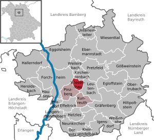
| Location of the community of Wiesenthau in the Forchheim district | ||
  |
||


Wiesenthau is a municipality near the Wiesent in the Upper Franconian district of Forchheim and a member of the Gosberg administrative community based in Pinzberg .
geography
Geographical location
Wiesenthau lies at the foot of the Walberla . Wiesenthau Castle is located in the village and has long been owned by the von Wiesenthau family .
Community structure
The Wiesenthau community has 2 districts :
- Schlaifhausen
- Wiesenthau
Neighboring communities
Neighboring communities are (starting from the north clockwise): Kirchehrenbach , Leutenbach , Pinzberg , Forchheim .
history
Until the church is planted
The community was first mentioned in a document in 1062. The lords of Wiesenthau held local rule from 1128 until they died out in 1814. The sovereign rulership was held by the Counts Schönborn , who were mediatized by Bavaria in 1806 . They ceded it in the course of border adjustments to the Grand Duchy of Würzburg of Archduke Ferdinand of Tuscany , with whom it finally fell back to Bavaria with the Treaties of Paris in 1814 . In the course of the administrative reforms in Bavaria, today's municipality was created with the municipal edict of 1818 .
Incorporations
With the territorial reform on May 1, 1978, the previously independent community of Schlaifhausen was incorporated into the community of Wiesenthau.
politics
mayor
Bernd Drummer (Bürgergemeinschaft Wiesenthau) has been mayor since 2014. Previously, this position had been held by Hans Weisel (Bürgergemeinschaft Wiesenthau) since 2002, who was 2nd mayor from 1996 to 2002.
Municipal council
The 2020 local elections resulted in the following distribution of seats in the local council:
- Citizens' Community Wiesenthau: 4 seats (± 0)
- For people, home and nature: 4 seats (+4 seats)
- Schlaifhausen village community: 2 seats (-1 seat)
- Free voters Wiesenthau / Schlaifhausen: 1 seat (−1 seat)
- Active citizens of Wiesenthau and Schlaifhausen: 1 seat (+1 seat)
The 2014 local elections resulted in the following distribution of seats in the local council:
- Bürgergemeinschaft Wiesenthau: 4 seats
- Schlaifhausen village community: 3 seats
- Young citizens Wiesenthau / Schlaifhausen: 2 seats
- Free voters Wiesenthau / Schlaifhausen : 2 seats
- New list for Wiesenthau and Schlaifhausen: 1 seat
coat of arms
The description of the coat of arms reads: “Above a pewter shield base split by red and silver, covered with a heraldic lily in confused colors, split by silver and red; in front four red diamonds lying one above the other, behind a silver flight. "
railroad
The community has a stop on the Forchheim – Ebermannstadt railway line and is integrated into the tariff of the greater Nuremberg area .
literature
- Johann Kaspar Bundschuh : Wiesenthau . In: Geographical Statistical-Topographical Lexicon of Franconia . tape 6 : V-Z . Verlag der Stettinische Buchhandlung, Ulm 1804, DNB 790364328 , OCLC 833753116 , Sp. 226 ( digitized version ).
Web links
- Entry on Wiesenthau's coat of arms in the database of the House of Bavarian History
Individual evidence
- ↑ "Data 2" sheet, Statistical Report A1200C 202041 Population of the municipalities, districts and administrative districts 1st quarter 2020 (population based on the 2011 census) ( help ).
- ^ Community Wiesenthau in the local database of the Bayerische Landesbibliothek Online . Bayerische Staatsbibliothek, accessed on January 5, 2020.
- ^ Federal Statistical Office (ed.): Historical municipality directory for the Federal Republic of Germany. Name, border and key number changes in municipalities, counties and administrative districts from May 27, 1970 to December 31, 1982 . W. Kohlhammer, Stuttgart / Mainz 1983, ISBN 3-17-003263-1 , p. 684 .
- ^ This is how the new Wiesenthau municipal council looks at nordbayern.de, March 19, 2014, accessed on November 6, 2017

Dormitz | Ebermannstadt | Effeltrich | Eggolsheim | Egloffstein | Forchheim | Gößweinstein | Graefenberg | Hallerndorf | Hausen | Heroldsbach | Hetzles | Hiltpoltstein | Igensdorf | Kirchehrenbach | Kleinsendelbach | Kunreuth | Langensendelbach | People Bach | Neunkirchen am Brand | Obertrubach | Pinzberg | Poxdorf | Pretzfeld | Lower ladder | Weilersbach | Weißenohe | Wiesenthau | Wiesenttal