
Wiesent (Regnitz)
| Wiesent | ||
 Limitation of Franconian Switzerland by various rivers |
||
| Data | ||
| Water code | EN : 2426 | |
| location |
Franconian Switzerland
|
|
| River system | Rhine | |
| Drain over | Regnitz → Main → Rhine → North Sea | |
| source | near Stadelhofen - Steinfeld 49 ° 58 ′ 38 ″ N , 11 ° 9 ′ 13 ″ E |
|
| Source height | approx. 445 m above sea level NN | |
| muzzle | near Forchheim in the Regnitz coordinates: 49 ° 42 '53 " N , 11 ° 3' 6" E 49 ° 42 '53 " N , 11 ° 3' 6" E |
|
| Mouth height | approx. 240 m above sea level NN | |
| Height difference | approx. 205 m | |
| Bottom slope | approx. 2.6 ‰ | |
| length | 78 km | |
| Catchment area | 1041 km² | |
| Discharge at the Muggendorf auxiliary gauge (63.6% of the catchment area) A Eo : 662 km² Location: 25 km above the mouth |
NNQ (June 26, 1974) MNQ 1957–2006 MQ 1957–2006 Mq 1957–2006 MHQ 1957–2006 HHQ (January 26, 1995) |
2.9 m³ / s 4.55 m³ / s 7.17 m³ / s 10.8 l / (s km²) 34.2 m³ / s 111 m³ / s |
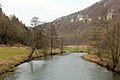
 Wiesent in Ebermannstadt |
||
The Wiesent is a right and eastern tributary of the Regnitz and the main river of Franconian Switzerland with a length of 78 kilometers.
Origin of name
The name of the Wiesent is derived from the Old High German name Wisantaha , which is made up of Wisant ( wisent ) and Aha (water) and means "water on which bison live".
geography
Wiesentquelle
The Wiesent spring is located in the west of Steinfeld , a district of the Stadelhofen community . It is a contained karst spring between the houses of the village, which rises in the reef dolomit of the Franconian Jura . The spring can have an enormous pouring down after heavy rain . The source is identified by the Bavarian State Office for the Environment as geotope 471Q001. See also the list of geotopes in the Bamberg district .
River course
The Wiesent initially flows in a south-easterly direction and turns to the south-west after Waischenfeld . From the mouth of the Aufseß in Doos it flows to the southeast, takes up the Püttlach at Behringersmühle and bends to the west. A few hundred meters downstream, it is reinforced by the Stempfermühlquelle (550 l / s). From Burggailenreuth via Muggendorf to the Neideck castle ruins near Streitberg , it flows to the northwest, then back to the southwest via Ebermannstadt and Pretzfeld . In Forchheim the Wiesent empties into the Regnitz.
Tributaries
The most important tributaries ( EZG > 10 km 2 ) of the Wiesent are:
- Kainach
- Truppach
- Zeubach
- Aufseß
- Püttlach
- Line ladder
- Trubach
- Ehrenbach
- Reithgraben
- Breitenbach
A more comprehensive list, including small tributaries, can be found in the list of rivers in the Wiesent river system .
Places along the Wiesent

- Steinfeld
- Treunitz
- hole
- Wiesentfels
- Hollfeld
- Plankenfels
- Waischenfeld
- Behringersmühle
- Muggendorf
- Streitberg
- Niederfellendorf
- Ebermannstadt
- Forchheim
freetime and recreation
The Wiesent offers the only river hiking trip through Franconian Switzerland that is still permitted and is particularly popular with canoeists .
According to a new legal ordinance by the government of Upper Franconia , canoeing is only permitted to a limited extent from 2006 onwards, rafting is generally prohibited:
- From October 1st to April 30th, paddling is prohibited between Plankenfels and Gasseldorf.
- From May 1 to September 30, the Wiesent can be used from Plankenfels to Sachsenmühle from 9 a.m. to 5 p.m. and from Sachsenmühle to Gasseldorf from 9 a.m. to 6 p.m.
- The upper course is closed all year round as far as Plankenfels.
- You may only paddle in the direction of flow.
- Getting in and out is only permitted at marked points.
- All organized boating events with more than ten boats are prohibited, exceptions must be approved.
- The local boat rental companies are only allowed to use a prescribed number of rental boats that are marked accordingly.
Picture gallery

Wiesent spring in Steinfeld

Museum railway along the Wiesent

Wiesent near the Rabeneck Castle

Wiesent at Behringersmühle
Wiesent near Muggendorf


literature
- Franz X. Bogner: Franconian Switzerland. An aerial portrait . Ellwanger, Bayreuth. ISBN 978-3925361623 .
- Johann Kaspar Bundschuh : Wiesent . In: Geographical Statistical-Topographical Lexicon of Franconia . tape 6 : V-Z . Verlag der Stettinische Buchhandlung, Ulm 1804, DNB 790364328 , OCLC 833753116 , Sp. 224-225 ( digitized version ).
Web links
- Wiesent: Flood risk management plan , water system , flood characteristics , flood events , government of Lower Franconia
- The Wiesent - river in the heart of Franconia
- Profile map of the Wiesent river water body
- Water body profile
Individual evidence
- ↑ Flood risk management plan, catchment area Bavarian Main: Wiesent planning unit
- ^ Deutsches Gewässerkundliches Jahrbuch Rheingebiet, Part II 2006 Bavarian State Office for the Environment, p. 101, accessed on October 4, 2017, at: bestellen.bayern.de (PDF, German, 23.6 MB).
- ^ Wolf-Armin von Reitzenstein : Lexicon of Franconian place names. Origin and meaning . Upper Franconia, Middle Franconia, Lower Franconia. CH Beck, Munich 2009, ISBN 978-3-406-59131-0 , p. 242 ( limited preview in Google Book search).
- ↑ Geotop: Wiesentquelle (accessed on July 7, 2015; PDF; 177 kB)