
Stadelhofen
| coat of arms | Germany map | |
|---|---|---|

|
Coordinates: 50 ° 0 ' N , 11 ° 12' E |
|
| Basic data | ||
| State : | Bavaria | |
| Administrative region : | Upper Franconia | |
| County : | Bamberg | |
| Management Community : | Steinfeld | |
| Height : | 478 m above sea level NHN | |
| Area : | 41.11 km 2 | |
| Residents: | 1245 (Dec. 31, 2019) | |
| Population density : | 30 inhabitants per km 2 | |
| Postal code : | 96187 | |
| Primaries : | 09207, 09504 | |
| License plate : | BA | |
| Community key : | 09 4 71 189 | |
| LOCODE : | DE SAO | |
| Community structure: | 10 districts | |
| Address of the municipal administration: |
Steinfeld 86 96187 Stadelhofen |
|
| Website : | ||
| Mayor : | Volker Will ( ÜWG ) | |
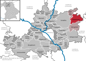
| Location of the municipality of Stadelhofen in the Bamberg district | ||
  |
||

Stadelhofen is a municipality in the Upper Franconian district of Bamberg and a member of the Steinfeld administrative community .
geography
Geographical location
The place and the community are on the edge of Franconian Switzerland on the motorway from Bamberg to Bayreuth .
Neighboring communities
Neighboring communities are (starting from the north in a clockwise direction): Weismain ( district of Lichtenfels ), Hollfeld ( district of Bayreuth ), Königsfeld , Scheßlitz and Wattendorf .
Community structure
Stadelhofen is divided into ten districts (population figures in brackets):
|
|
Status: 2014
There are the following districts : Schederndorf, Stadelhofen, Steinfeld, Wölkendorf, Hohenhäusling.
history
Until the church is planted
The place was first mentioned in a document in 1248. The place name probably means Stadelhofen to the farms, with an Stadel are provided . However, it may also be a modified personal name.
Stadelhofen is located at the point where an old military road from Bamberg to Kulmbach crossed the path from Weismain to Hollfeld .

Even if Stadelhofen was mentioned late in a document, it is certain that the area was already settled around the year 630. In a map from 1595, the area around Stadelhofen is called "Uf dem Gebürg".
In 1386 the Truhendinger sold the place for 2000 Heller to the bishop of Bamberg. As part of the Bamberg Monastery , the place belonged to the Franconian Empire from 1500 . Since the Reichsdeputationshauptschluss of 1803, the place, like large parts of Franconia, has belonged to Bavaria (see also History of Franconia ). In the course of the administrative reforms in Bavaria , today's municipality was created with the municipal edict of 1818 .
In addition to Stadelhofen, there was also a now lost parish of Leuchnitz in the area, which was somewhere between Weismain and Steinfeld.
The Catholic parish church of Stadelhofen, which is dedicated to Saint Peter and Saint Catherine, dates from the 18th century. The tower with its pointed helmet is a landmark of the area. The high altar was bought from the Litzendorfer in 1721 .
Incorporations
On July 1, 1973, the previously independent community of Wölkendorf was incorporated. On May 1, 1978, Schederndorf and Steinfeld and parts of the dissolved community of Hohenhäusling were added.
Population development
In the period from 1988 to 2018, the population decreased from 1269 to 1247 by 22 inhabitants or 1.7%; it stagnated at around 1250 inhabitants.
| year | Residents |
|---|---|
| 1961 | 1412 |
| 1970 | 1404 |
| 1987 | 1291 |
| 1991 | 1248 |
| 1995 | 1244 |
| 2000 | 1274 |
| 2005 | 1261 |
| 2010 | 1240 |
| 2015 | 1227 |
religion
According to the census on May 9, 2011, 92.7% of the population are Roman Catholic and 3.1% Evangelical Lutheran. 4.2% have another religion or are non-denominational.
politics
mayor
Mayor has been Volker Will (non-partisan voter community) since May 1, 2020, who prevailed in a runoff election with 58.01% of the vote. He is the successor to Ludwig Göhl (non-partisan voter community). In 2002 he succeeded Heinrich Linz (CSU) and was re-elected in 2008 with 63.53% of the vote. In 2014, Göhl received 56.91% of the votes in an opposing candidate from the Free Voter.
City council election 2014
In the 2014 municipal council elections , the non-partisan voter community had 5 seats, the free voters 3 seats and the CSU 4 seats.
City council election 2008
In the 2008 municipal council elections , the non-partisan voter community had 6 seats (47.7%), the free voters 4 seats (29.9%) and the CSU 2 seats (22.4%). The turnout was 84.1%.
Local council election 2002
In the local council elections in 2002, the non-partisan voter community had 6 seats (49.7%), the CSU 3 seats (26.6%) and the free voters 3 seats (23.7%). The turnout was 90.1%.
coat of arms
The description of the coat of arms reads: "Split of red and silver, at the front between the golden head of the shield and the golden foot of the shield a silver roch , behind between the blue head of the shield and the foot of the shield is a red heraldic rose with a golden lug and green sepals."
The Roch is reminiscent of the Neustätter family. The red bar in the golden field refers to the Counts of Truhendingen. The rose is the coat of arms of the Lords of Aufseß . The colors red and silver refer to the Giech and Förtsch families , ministerials of the Dukes of Andechs-Meranien .

Architectural monuments
Economy and Infrastructure
Economy including agriculture and forestry
In 1998, according to official statistics, there were no employees at the place of work subject to social insurance contributions in the manufacturing industry 61 and in the trade and transport sector. In other economic areas, 30 people were employed at the place of work subject to social security contributions. There were a total of 468 employees at the place of residence subject to social security contributions. There were five companies in the manufacturing sector and one in the construction sector. In addition, there were 138 farms in 1999 with an agricultural area of 2286 hectares, of which 2043 hectares were arable land and 242 hectares were permanent green space.
Breweries
There are still two breweries in the municipality, the Will brewery in Schederndorf and the Hübner brewery in Steinfeld. The Schrenker brewery in Stadelhofen also existed until 1985.
Voluntary fire brigades
There are the volunteer fire departments Eichenhüll / Wotzendorf, Hohenhäusling, Roßdorf am Berg, Schederndorf, Steinfeld, Stadelhofen and Wölkendorf / Pfaffendorf. The Stadelhofen fire brigade has an LF 8/6 with a rescue kit for technical assistance .
education
There is a kindergarten with 50 places and an elementary school with four teachers and 86 students (as of 1999).
Sons and daughters of the church
- Hans Albrecht (1923–2006), politician (FDP), member of the state parliament in Baden-Württemberg, state parliament vice-president, honorary citizen of the city of Wiernsheim

Town center
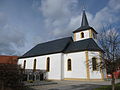
church

Interior of the church
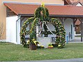
Easter fountain

Industrial center

sports ground

Schederndorf town center


Individual evidence
- ↑ "Data 2" sheet, Statistical Report A1200C 202041 Population of the municipalities, districts and administrative districts 1st quarter 2020 (population based on the 2011 census) ( help ).
- ↑ Information sheet of the administrative association Steinfeld from January 23, 2015
- ↑ Johannes Neumann: The Reichsdeputationshauptschluss of 1803: Requirements and consequences (PDF file; 179 kB)
- ^ Federal Statistical Office (ed.): Historical municipality directory for the Federal Republic of Germany. Name, border and key number changes in municipalities, counties and administrative districts from May 27, 1970 to December 31, 1982 . W. Kohlhammer GmbH, Stuttgart / Mainz 1983, ISBN 3-17-003263-1 , p. 672 and 673 .
literature
- Josef Urban (Ed.): Wölkendorf. The village - the chapel - the people. History for the 100th anniversary of the chapel . (= From the Main to the Jura; special issue 3). Eggolsheim 2005; including: Thomas Gunzelmann, Klaus Rupprecht: Wölkendorf - Village "on the mountain" on the "Path to Paradise" , pp. 11–49 ( PDF )
Web links
- Entry on the coat of arms of Stadelhofen in the database of the House of Bavarian History
- Stadelhofen: Official statistics of the LfStat (PDF; 1.24 MB)
Oak cover | Hohenhäusling | Hop mill | Pfaffendorf | Roßdorf am Berg | Schederndorf | Stadelhofen | Steinfeld | Wölkendorf | Wotzendorf

Altendorf | Baunach | Bischberg | Breitengüßbach | Burgebrach | Burgwindheim | Buttenheim | Ebrach | Frensdorf | Gerach | Gundelsheim | Hallstadt | Heiligenstadt in Upper Franconia | Hirschaid | Kemmern | Koenigsfeld | Louder | Lisberg | Litzendorf | Memmelsdorf | Oberhaid | Pettstadt | Pommersfelden | Priesendorf | Rattelsdorf | Reckendorf | Scheßlitz | Key field | Schönbrunn im Steigerwald | Stadelhofen | Stegaurach | Strullendorf | Viereth-Trunstadt | Walsdorf | Wattendorf | Zapfendorf
Community-free areas
Ebracher Forst |
Eichwald |
Geisberger Forest |
Main Bog Forest |
Koppenwinder Forest |
Lindach |
Semberg |
Steinachsrangen |
Winkelhofer Forest |
Zückshuter Forest