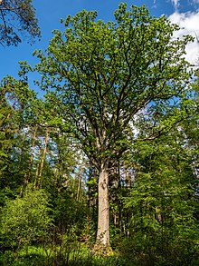
Main Bog Forest
The main moor forest is a community-free area east of the city of Bamberg . It is a vast pine -Waldgebiet that of the A 73 is cut. The forest is partly US -Hoheitsgebiet and was a training area of the US Army used until their withdrawal, 2014.
The Kunigundenruh rifle house is freely accessible in the forest . Nearby is the Kunigundenruh Stone, a torture that is reminiscent of the Empress Kunigunde .
history
The main moor forest was created on sand that was removed during the Ice Age and mixed with weathered Jura limestone , which also covers large parts of the Bamberg Basin . The sand was blown in the east of the city of Bamberg by the prevailing westerly wind for thousands of years to form dunes , which formed the basis of the main moor forest. As Reich Forest , the area was directly under the Frankish kings and German, already the Carolingian had in Königsfeld a first mentioned in 741 royal court , to which the forest once stretched.
The wood of the pines of the main moor forest is of particularly high quality, as the pine has few knots and hardly warps, making it ideal for the blades of Dutch windmills and aircraft propellers, for example.
Meanwhile the loss of land and animal species is enormous. Since 1915, bird species such as hoopoe , little owl , red kite and black kite have disappeared from the area. At that time, the main moor forest still extended to the Bamberg train station. In the last few years the annual biotope loss was twelve hectares with a total biotope area of 580 hectares in 1989.
The Rennsteig in the main moor forest
A Rennsteig , a historical connecting path, runs through the main moor forest , which bypassed the impassable Regnitz valley , which is threatened by floods . Via Roßdorf and Amlingstadt it led to Hirschaid and on to Forchheim . This Rennsteig ran as a shortcut to the old road across the main moor forest. The couriers could carry their messages there on foot or on horseback in the protection of the forest, away from the trade route.
Quoting from an early 20th century travel guide
In his travel guide about Bamberg and the surrounding area from around 1912, the author Dietrich Amende also describes the main moor forest:
- “The greatest Bamberg forest is the main moor. This wonderful coniferous forest, which extends up to the heights of the Jura (Geisberg, Stammberg), has a west-east extension of approx. 13, a north-south of approx. 10 kilometers. You can get to it either on foot over the Kunigundendamm past the parade ground of the Kaiser-Uhlans in the Wunderburg or through the Pödeldorferstraße directly at the last tram stop at the barracks of the 5th Infantry Regiment Grand Duke Ernst Ludwig von Hessen .
- In the main moor forest everyone gets their money's worth: the nature lover, botanist, forester, the fan of equestrian sports (the very extensive bridle paths were mainly laid out by King Otto of Greece, who resided in Bamberg after his renunciation of the throne), the friend of cycling, especially those in need of relaxation. - The Kunigundenruh in the forest is wrapped in legend. "
quoted from Dr. Dietrich Amende: Bamberg and Franconia. Bamberg undated (around 1912)
See also
- List of unincorporated areas in Bavaria
- List of architectural monuments in unincorporated areas in Bavaria
Web links
- Community-free area Hauptsmoorwald in OpenStreetMap (accessed on August 25, 2017)
- Hauptsmoorwald Golf Club
Individual evidence
- ↑ Jürgen Gerdes Nature Conservation in Bamberg , Collection of Articles 2001: " Natural Heritage Bamberg - On the Development of the Bamberg Natural Landscape "
Coordinates: 49 ° 53 ′ 10.3 " N , 10 ° 57 ′ 56.9" E


