
Key field
| coat of arms | Germany map | |
|---|---|---|

|
Coordinates: 49 ° 45 ' N , 10 ° 37' E |
|
| Basic data | ||
| State : | Bavaria | |
| Administrative region : | Upper Franconia | |
| County : | Bamberg | |
| Height : | 300 m above sea level NHN | |
| Area : | 70.25 km 2 | |
| Residents: | 5925 (Dec. 31, 2019) | |
| Population density : | 84 inhabitants per km 2 | |
| Postal code : | 96132 | |
| Primaries : | 09552, 09555, 09546, 09548 | |
| License plate : | BA | |
| Community key : | 09 4 71 220 | |
| LOCODE : | DE SFD | |
| City structure: | 22 parts of the community | |
City administration address : |
Marktplatz 5 96132 Schlüsselfeld |
|
| Website : | ||
| Mayor : | Johannes Krapp ( CSU ) | |
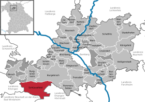
| Location of the town of Schlüsselfeld in the Bamberg district | ||
  |
||

Schlüsselfeld is a town on the southwestern edge of the Upper Franconian district of Bamberg .
geography


The city is located southwest of Bamberg in the Steigerwald in the valley of the rich Ebrach on the Bavarian Porcelain Route .
Neighboring communities
Neighboring communities are (starting from the north clockwise): Burgebrach , Mühlhausen , Wachenroth , Vestenbergsgreuth (all three districts Erlangen-Höchstadt , Middle Franconia ), Burghaslach ( district Neustadt an der Aisch-Bad Windsheim , Middle Franconia), Geiselwind ( district Kitzingen , Lower Franconia ) and Burgwindheim .
City structure
Schlüsselfeld has 22 officially named parts of the municipality : (population figures in brackets, as of June 30, 2019)
|
|
|
The following districts exist (all formerly independent communities that were retained as cadastral districts): Aschbach, Eckersbach, Elsendorf, Heuchelheim, Reichmannsdorf, Schlüsselfeld, Thüngfeld, Untermelsendorf and Ziegelsambach.
climate
The average annual temperature in Schlüsselfeld is 8.24 ° C.
history


Until the church is planted
The place was first mentioned in 1315 as "Slüsselfeld". At that time it was planned by Konrad II von Schlüsselberg . On June 10, 1336 Key field received by Emperor Louis of Bavaria , the market rights . After the death of its founder it fell to the bishops of Bamberg and Würzburg. By settlement, Würzburg also acquired Bamberg's share in Schlüsselfeld in 1390. In 1396, the Schlüsselfeld market was granted city rights . The Würzburg bishops expanded Schlüsselfeld into an office and chose Thüngfeld Castle as the official seat.
On the town hall built in 1723, a Latin inscription proclaims the following saying:
- "This house hates unrest, loves peace, punishes crime, upholds justice, honors goodness."
As part of the high pin Würzburg , which for 1500 Franconian Circle belonged to the penny Office key field was in 1803 in Bavaria's favor secularized , fell in the Peace of Pressburg (1805) newly to the Grand Duchy of Würzburg and finally came back on field adjustments in 1810 to Bavaria .
As part of the municipal edict , the tax district Schlüsselfeld was formed, to which Thüngbach belonged. In the same year the rural community of Schlüsselfeld was established, which was congruent with the tax district. In 1813 it was raised to the status of a municipality. In administration and jurisdiction it was subordinate to the district court of Höchstadt and in the financial administration to the Rentamt Höchstadt . From 1862, Schlüsselfeld was administered by the district office of Höchstadt an der Aisch (renamed the district of Höchstadt an der Aisch in 1938 ) and continued to be administered by the rent office of Höchstadt (1920–1929: tax office Höchstadt , from 1929: tax office Forchheim ). The jurisdiction remained with the district court of Höchstadt until 1879, 1880–1959 district court of Höchstadt , from 1959 district court of Forchheim . The municipality originally had an area of 9.384 km².
Territorial reform of the 1970s
Before the territorial reform , Schlüsselfeld belonged to the dissolved district of Höchstadt an der Aisch ( Upper Franconia ). On June 30, 1972, the city and most of the district were incorporated into the Erlangen-Höchstadt district (initially called the Erlangen district) and thus incorporated into the Central Franconia administrative region . On May 1, 1978, Schlüsselfeld moved to the Bamberg district and thus back to Upper Franconia.
On July 1, 1972, the previously independent community of Heuchelheim (with Rambach and Debersdorf) was incorporated. Untermelsendorf was added on January 1, 1975. On May 1, 1978 the market in Aschbach, Eckersbach, Elsendorf (with Possenfelden, Lach and Reumannswind), Reichmannsdorf, Thüngfeld and Ziegelsambach followed. On January 1, 1982, the Reumannswind district , which had more than 50 inhabitants at the time, was assigned to the Wachenroth market .
Population development
In the period from 1988 to 2018, the city grew from 5002 to 5941 by 939 inhabitants or by 18.8%.
Municipality of Schlüsselfeld
| year | 1827 | 1840 | 1852 | 1861 | 1867 | 1871 | 1875 | 1880 | 1885 | 1890 | 1895 | 1900 | 1905 | 1910 | 1919 | 1925 | 1933 | 1939 | 1946 |
|---|---|---|---|---|---|---|---|---|---|---|---|---|---|---|---|---|---|---|---|
| Residents | 624 | 710 | 661 | 699 | 716 | 754 | 744 | 732 | 717 | 704 | 671 | 689 | 676 | 700 | 718 | 738 | 680 | 606 | 1071 |
| Houses | 111 | 132 | 113 | 135 | |||||||||||||||
| source |
| year | 1950 | 1961 | 1970 | 1987 | 1995 | 2008 | 2017 |
|---|---|---|---|---|---|---|---|
| Residents | 1060 | 940 | 1188 | 5034 | 5689 | 5713 | 5909 |
| Houses | 138 | 171 | 1245 | 1648 | |||
| source |
District of Schlüsselfeld
| year | 1827 | 1861 | 1871 | 1885 | 1900 | 1925 | 1950 | 1961 | 1970 | 1987 | 2019 |
|---|---|---|---|---|---|---|---|---|---|---|---|
| Residents | 560 | 629 | 677 | 641 | 617 | 665 | 971 | 883 | 1133 | 1101 | 1413 |
| Houses | 120 | 99 | 124 | 125 | 160 | 284 | |||||
| source |
Religions
As early as the 19th century, there were Jewish families in the district of Aschbach who set up a Jewish cemetery . A memorial stone at the cemetery entrance with names of the victims of the Shoah during the Nazi regime commemorates the victims .
According to the census on May 9, 2011, 69.0% of the population belonged to the Catholic Church, 20.3% to the Evangelical Church and 10.7% to another or no religious community.
In 2004 an Evangelical Free Church congregation ( Baptists ) was founded.
politics
City council
The city council consists of 20 women and men who are elected every six years in local elections. The following table shows the distribution of seats after the most recent local elections on March 15, 2020 and the distribution of seats after the previous elections in 2014, 2008 and 2002.
| Party / list | Seats 2020 |
Seats 2014 |
Seats 2008 |
Seats 2002 |
|
| CSU | 9 | 9 | 8th | 9 | |
| SPD | 3 | 4th | 3 | 4th | |
| Free community of voters | 5 | 4th | 6th | 3 | |
| Independent community of citizens | 3 | 3 | 3 | 3 | |
| Non-partisan Christian voter community | - | - | - | 1 |
mayor
Mayor has been Johannes Krapp (CSU) since 2014, who received 93.42% of the votes without opposing candidates and was re-elected in 2020 without opposing candidates with 94.64%. His predecessor since 1996 was Georg Zipfel (FW), born in 1953 and also active as chairman of the local Steigerwald Club, who was last re-elected to a third term in 2008 with 79.13% of the votes.
badges and flags
|
|
Blazon : "In red a slanted silver key with the beard pointing upwards, accompanied by two six-pointed golden stars ."
Gold-red-white municipal flag (originally white-red flag) |
| Justification for the coat of arms: The key not only refers to the place name, but also reminds by its position and color of the coat of arms of the noble free von Schlüsselberg, who died out in 1347, as the owner and founder of the place, which was named as the property of Konrad von Schlüsselberg in 1342. The current coat of arms first appeared in a seal from the 16th century. |
Town twinning
![]() Schlüsselfeld has had a partnership with the northern Hungarian municipality of Hévízgyörk since 2005 .
Schlüsselfeld has had a partnership with the northern Hungarian municipality of Hévízgyörk since 2005 .
Culture and sights
Museums


The city museum is housed in the old town hall and consists of four rooms. Room 1 is dedicated to the geology of the Keuper , room 2 shows the nature in the Steigerwald. In room 3 there is a folklore exhibition and in room 4, in addition to the history of the town of Schlüsselfeld, that of the Reichmannsdorf porcelain factory is shown.
Architectural monuments
Worth seeing in the area of the city of Schlüsselfeld are:
- In Schlüsselfeld: the city gate tower with remains of the city wall and two round towers, the Petrusbrunnen, the old town hall with pillory, the new town hall, the Gothic parish church, the church of Klein-Mariazell in the Steigerwald (with a copy of the miraculous image of Mariazell in Styria)
- In Aschbach: the baroque palace, the Church of the Assumption of the Virgin Mary, the Protestant church with St. Mary's altar, the Jewish cemetery
- In Reichmannsdorf: the Dientzenhofer Palace
- In Heuchelheim the Dreifrankenstein
Economy and Infrastructure

The city of Schlüsselfeld is recognized as a small center .
traffic
The state road 2260 runs west of Geiselwind and east of Wachenroth . From the St 2260, the state road 2261 branches off towards the southwest, where it leads directly to junction 77 of the federal motorway 3 and on to Burghaslach . The state road 2262 runs northeast to Reichmannsdorf . A community road runs northwest to Derbsdorf . Another communal road runs south to Burghaslach.
The Frensdorf – Schlüsselfeld rail line , which is only used for freight traffic, leads to Schlüsselfeld .
The Franconian Marienweg runs through the village .
Breweries
There are two breweries in the city: the Sternbräu (Scheubel) in Schlüsselfeld and the Hertl brewery in Thüngfeld, founded in 2012.
List of former breweries:
- Scharold Brewery, Schlüsselfeld, until 1961
- Windfelder Brewery, Elsendorf, until 1965
- Josef Amtmann Brewery, Schlüsselfeld, until 1973
- Kronen Brewery Maierhöfer, Schlüsselfeld, until 1973
- Ritter Brewery, Heuchelheim, until 1985
- Scheubel Brewery, Possenfelden, until 2005
- Sternbräu, Elsendorf, until 2013 (can be brewed in a contract brewing process)
- Adlerbräu (Amtmann), Schlüsselfeld, until 2013 (can be brewed in a contract brewing process)
Companies
- Concorde, PhoeniX and Morelo, three RV manufacturers upscale
- The McFit fitness center chain
- Veit Dennert KG , a family company that produces system building materials, massive prefabricated houses and insulation materials
- The ADAC driving experience center in Schlüsselfeld offers extensive training and event options.
- KB Container GmbH sells and rents new and used containers and container buildings .
- Röder fireworks
Voluntary fire brigades
There are voluntary fire departments in the districts of Aschbach, Eckersbach, Elsendorf, Heuchelheim, Reichmannsdorf with Untermelsendorf, Schlüsselfeld, Thüngfeld and Ziegelsambach / Wüstenbuch.
Personalities associated with the city
- Robert Hemmerlein (* 1959), soccer player, grew up in the Reichmannsdorf district
- Peter Heinz (* around 1969), resident ophthalmologist and chairman of the professional association of ophthalmologists in Germany
literature
- Johann Kaspar Bundschuh : Key field . In: Geographical Statistical-Topographical Lexicon of Franconia . tape 5 : S-U . Verlag der Stettinische Buchhandlung, Ulm 1802, DNB 790364328 , OCLC 833753112 , Sp. 137 ( digitized version ).
- Georg Daßler (Ed.): District of Höchstadt ad Aisch. Past and present . Verl. F. Authorities and Wirtschaft Hoeppner, Aßling-Munich 1970, DNB 457004320 , p. 122-123 .
- Hanns Hubert Hofmann : Höchstadt-Herzogenaurach (= Historical Atlas of Bavaria, part Franconia . I, 1). Commission for Bavarian State History, Munich 1951, DNB 452071143 , p. 135 ( digitized version ).
- Wolf-Armin von Reitzenstein : Lexicon of Franconian place names. Origin and meaning . Upper Franconia, Middle Franconia, Lower Franconia. CH Beck, Munich 2009, ISBN 978-3-406-59131-0 , p. 199 .
- Gottfried Stieber: Mockery of the mountain . In: Historical and topographical news from the Principality of Brandenburg-Onolzbach . Johann Jacob Enderes, Schwabach 1761, p. 500–501 ( digitized version ).
- Pleikard Joseph Stumpf : Key field . In: Bavaria: a geographical-statistical-historical handbook of the kingdom; for the Bavarian people . Second part. Munich 1853, p. 591 ( digitized version ).
Web links
- Local history, photos and history of the church and fortifications at Foracheim
- Key field: Official statistics of the LfStat (PDF; 1.24 MB)
- Key field in the Topographia Franconiae of the University of Würzburg , accessed on October 25, 2019.
Individual evidence
- ↑ "Data 2" sheet, Statistical Report A1200C 202041 Population of the municipalities, districts and administrative districts 1st quarter 2020 (population based on the 2011 census) ( help ).
- ↑ https://www.schluesselfeld.de/mein-schluesselfeld/im-portraet/zahlen-daten-ffekten
- ^ Municipality of Schlüsselfeld in the local database of the Bavarian State Library Online . Bayerische Staatsbibliothek, accessed on October 11, 2019.
- ^ W.-Av Reitzenstein, p. 199
- ↑ G. Daßler (Ed.), P. 122f.
- ↑ HH Hofmann, p. 135
- ↑ a b c Bavarian State Statistical Office (ed.): Official city directory for Bavaria, territorial status on October 1, 1964 with statistical information from the 1961 census . Issue 260 of the articles on Bavaria's statistics. Munich 1964, DNB 453660959 , Section II, Sp. 681 ( digitized version ).
- ^ Wilhelm Volkert (ed.): Handbook of Bavarian offices, communities and courts 1799–1980 . CH Beck, Munich 1983, ISBN 3-406-09669-7 , p. 484 .
- ^ Federal Statistical Office (ed.): Historical municipality directory for the Federal Republic of Germany. Name, border and key number changes in municipalities, counties and administrative districts from May 27, 1970 to December 31, 1982 . W. Kohlhammer, Stuttgart / Mainz 1983, ISBN 3-17-003263-1 , p. 711 .
- ^ Federal Statistical Office (ed.): Historical municipality directory for the Federal Republic of Germany. Name, border and key number changes in municipalities, counties and administrative districts from May 27, 1970 to December 31, 1982 . W. Kohlhammer, Stuttgart / Mainz 1983, ISBN 3-17-003263-1 , p. 814 .
- ↑ a b c Only inhabited houses are given, designated as residential buildings from 1871 to 2017 .
- ^ A b Karl Friedrich Hohn (Hrsg.): Geographical-statistical description of the Upper Main district . J. Dederich, Bamberg 1827, p. 133 ( digitized version ). For the community of Schlüsselfeld plus the residents of Thüngbach (p. 134)
- ↑ a b c d e f g h i j k l m Bavarian State Statistical Office (Hrsg.): Historical municipality register: The population of the municipalities of Bavaria from 1840 to 1952 (= contributions to Statistics Bavaria . Issue 192). Munich 1954, DNB 451478568 , p. 146 , urn : nbn: de: bvb: 12-bsb00066439-3 ( digitized version ).
- ↑ a b Joseph Heyberger, Chr. Schmitt, v. Wachter: Topographical-statistical manual of the Kingdom of Bavaria with an alphabetical local dictionary . In: K. Bayer. Statistical Bureau (Ed.): Bavaria. Regional and folklore of the Kingdom of Bavaria . tape 5 . Literary and artistic establishment of the JG Cotta'schen Buchhandlung, Munich 1867, Sp. 874 , urn : nbn: de: bvb: 12-bsb10374496-4 ( digitized version ).
- ↑ a b Kgl. Statistical Bureau (ed.): Complete list of localities of the Kingdom of Bavaria. According to districts, administrative districts, court districts and municipalities, including parish, school and post office affiliation ... with an alphabetical general register containing the population according to the results of the census of December 1, 1875 . Adolf Ackermann, Munich 1877, 2nd section (population figures from 1871, cattle figures from 1873), Sp. 1047 , urn : nbn: de: bvb: 12-bsb00052489-4 ( digitized ).
- ↑ a b K. Bayer. Statistical Bureau (Ed.): Localities directory of the Kingdom of Bavaria. According to government districts, administrative districts, ... then with an alphabetical register of locations, including the property and the responsible administrative district for each location. LIV. Issue of the contributions to the statistics of the Kingdom of Bavaria. Munich 1888, Section III, Sp. 992 ( digitized version ).
- ↑ a b K. Bayer. Statistical Bureau (Ed.): Directory of localities of the Kingdom of Bavaria, with alphabetical register of places . LXV. Issue of the contributions to the statistics of the Kingdom of Bavaria. Munich 1904, Section II, Sp. 1040 ( digitized version ).
- ↑ a b Bavarian State Statistical Office (ed.): Localities directory for the Free State of Bavaria according to the census of June 16, 1925 and the territorial status of January 1, 1928 . Issue 109 of the articles on Bavaria's statistics. Munich 1928, Section II, Sp. 1074 ( digitized version ).
- ↑ a b Bavarian State Statistical Office (ed.): Official place directory for Bavaria - edited on the basis of the census of September 13, 1950 . Issue 169 of the articles on Bavaria's statistics. Munich 1952, DNB 453660975 , Section II, Sp. 926 ( digitized version ).
- ↑ a b Bavarian State Statistical Office (Hrsg.): Official local directory for Bavaria . Issue 335 of the articles on Bavaria's statistics. Munich 1973, DNB 740801384 , p. 173 ( digitized version ).
- ↑ a b Bavarian State Office for Statistics and Data Processing (Ed.): Official local directory for Bavaria, territorial status: May 25, 1987 . Issue 450 of the articles on Bavaria's statistics. Munich November 1991, DNB 94240937X , p. 291 ( digitized version ).
- ↑ a b LfStat : key field: official statistics. In: statistik.bayern.de. Pages 6 and 12 , accessed October 25, 2019 .
- ↑ Numbers, data, facts on the schluesselfeld.de website
- ↑ Memorial sites for the victims of National Socialism. A documentation, volume 1. Federal Agency for Civic Education, Bonn 1995, ISBN 3-89331-208-0 , p. 191
- ↑ Information on the municipality's website.
- ^ Entry on the coat of arms of Schlüsselfeld in the database of the House of Bavarian History
- ↑ key field. In: Kommunalflaggen.eu. Retrieved July 8, 2020 .
- ↑ Archived copy ( memento of the original from March 31, 2008 in the Internet Archive ) Info: The archive link was inserted automatically and has not yet been checked. Please check the original and archive link according to the instructions and then remove this notice.
Aschbach | Attelsdorf | Bernroth | Debersdorf | Eckersbach | Elsendorf | Fall Mastery | Güntersdorf | Heuchelheim | Mockery of the mountain | Hop mill | Laugh | Obermelsendorf | Possenfelden | Rambach | Reichmannsdorf | Key field | Thüngbach | Thüngfeld | Untermelsendorf | Desert Book | Brick Sambach

Altendorf | Baunach | Bischberg | Breitengüßbach | Burgebrach | Burgwindheim | Buttenheim | Ebrach | Frensdorf | Gerach | Gundelsheim | Hallstadt | Heiligenstadt in Upper Franconia | Hirschaid | Kemmern | Koenigsfeld | Louder | Lisberg | Litzendorf | Memmelsdorf | Oberhaid | Pettstadt | Pommersfelden | Priesendorf | Rattelsdorf | Reckendorf | Scheßlitz | Key field | Schönbrunn im Steigerwald | Stadelhofen | Stegaurach | Strullendorf | Viereth-Trunstadt | Walsdorf | Wattendorf | Zapfendorf
Community-free areas
Ebracher Forst |
Eichwald |
Geisberger Forest |
Main Bog Forest |
Koppenwinder Forest |
Lindach |
Semberg |
Steinachsrangen |
Winkelhofer Forest |
Zückshuter Forest