
Strullendorf
| coat of arms | Germany map | |
|---|---|---|

|
Coordinates: 49 ° 50 ' N , 10 ° 58' E |
|
| Basic data | ||
| State : | Bavaria | |
| Administrative region : | Upper Franconia | |
| County : | Bamberg | |
| Height : | 251 m above sea level NHN | |
| Area : | 31.7 km 2 | |
| Residents: | 7989 (Dec. 31, 2019) | |
| Population density : | 252 inhabitants per km 2 | |
| Postal code : | 96129 | |
| Primaries : | 09543, 09505 | |
| License plate : | BA | |
| Community key : | 09 4 71 195 | |
| Community structure: | 8 parts of the community | |
| Address of the municipal administration: |
Forchheimer Str. 32 96129 Strullendorf |
|
| Website : | ||
| Mayor : | Wolfgang Desel ( CSU ) | |
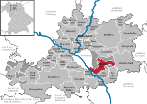
| Location of the municipality of Strullendorf in the Bamberg district | ||
  |
||

Strullendorf is a municipality in the Upper Franconian district of Bamberg in Bavaria with around 8,000 inhabitants.
geography

Geographical location
Strullendorf lies in a valley and is partially surrounded by the main moor forest, near which the main moor hall is located. The main moor forest extends to Bamberg and was partially used by the US Army as a military training area.
Neighboring communities
Neighboring communities are (starting from the north in a clockwise direction): Litzendorf , Heiligenstadt in Upper Franconia , Buttenheim , Hirschaid , Pettstadt and Bamberg .
The lime tree avenue with its large old trees is considered to be scenic in Strullendorf.
Community structure
Strullendorf is divided into eight districts (population figures in brackets as of December 31, 2010):
- Amlingstadt (695)
- Geisfeld (928)
- Leesten (259)
- Mistendorf (540)
- Roßdorf am Forst (514)
- Strullendorf (4167)
- Wernsdorf (441)
- Zeegendorf (572)
There are the following districts : Amlingstadt, Geisfeld, Leesten, Mistendorf, Roßdorf am Forst, Wernsdorf, Zeegendorf, Strullendorf, Geisberger Forst, Hauptsmoor.
history
Until the church is planted
Strullendorf owes its first documentary mention to a pledge of 1247 by Heinrich I von Bilversheim . The Tockler patrician family from Nuremberg owned the Tocklerhof in Strullendorf until the 16th century. This and the Zeidelhuben (forest beekeeping) mentioned as early as 1348 were of great economic importance for the place. In 1796 the place was burned down by the French. Strullendorf belonged to the bishopric of Bamberg and from 1500 to the Franconian Empire . Since the Reichsdeputationshauptschluss of 1803, the place, like large parts of Franconia, has belonged to Bavaria (see also History of Franconia ). In the course of the administrative reforms in the Kingdom of Bavaria , today's municipality was created with the municipal edict of 1818 .
The name of the place is derived from a Franconian noble free named Strollo.
Incorporations
On January 1, 1972, Leesten, Mistendorf and Wernsdorf were incorporated. On July 1, 1972, Strullendorf ceded the Bughof district to Bamberg. On January 1, 1978 Roßdorf am Forst was added. Amlingstadt, Geisfeld and Zeegendorf followed on May 1, 1978.
Population development
In the period from 1988 to 2018, the municipality grew from 6572 to 8055 by 1483 inhabitants or 22.6%.
- 1961: 4740 inhabitants
- 1970: 5736 inhabitants
- 1987: 6489 inhabitants
- 1991: 7132 inhabitants
- 1995: 7705 inhabitants
- 2000: 7846 inhabitants
- 2005: 7823 inhabitants
- 2010: 7660 inhabitants
- 2015: 7956 inhabitants
religion
According to the census on May 9, 2011, 74.7% of the population are Roman Catholic and 11.0% Evangelical Lutheran. 14.3% have another religion or are non-denominational.
politics
mayor
On March 24, 2014, the newly elected First Mayor Wolfgang Desel was sworn in by the CSU in a public council meeting. He won the election in the first ballot with 58.32% of the valid votes against the candidates of the SPD and the civic bloc. In the local elections in 2020 he was confirmed in office with two opposing candidates from the SPD and the NL with 65.68% of the votes.
His predecessor from 1996 to 2013 was Andreas Schwarz (SPD), who was re-elected in 2008 with 71.43% of the vote against an opposing candidate. In 1996, Schwarz was able to prevail against the then incumbent Bruno Weiß (CSU) with 65.29% of the vote, six years later he scored 69.97% in an opposing candidate.
In the 2013 federal election , Schwarz was elected to the Bundestag via the SPD's state list. Until the newly elected mayor took office, the second mayor Ludwig Werner took over the official business of the citizen block.
City council election 2014
The municipal council consists of the following parties and constituencies:
City council election 2008
Local council election 2002
Youth parliament
Since 2005, Strullendorf has had a youth parliament with its own young mayor. The youth parliament has a budget of 1200 euros per year.
coat of arms
The official description ( blazon ) of the Strullendorf coat of arms reads: “Divided by gold and red; above three two-to-one black carrot heads, below a golden bee. "
The municipality has had the coat of arms since 1965 by resolution of the then municipal council and with the consent of the Bavarian Ministry of the Interior. It contains elements (black Moorish heads) of the Tockler family coat of arms. The bee in the lower red part indicates the historically documented forest beekeeping in the main moor forest.
Architectural monuments
Economy and Infrastructure
Economy including agriculture and forestry
The Hirschaid power plant was built in 1922 . In 1998, according to official statistics, there were 900 employees at the place of work in the manufacturing sector and in the trade and transport sector. There were a total of 2923 employees at the place of residence subject to social security contributions. There were four companies in the manufacturing sector and twelve in the construction sector. In addition, in 1999 there were 96 farms with an agricultural area of 1515 hectares, of which 1231 hectares were arable land and 279 hectares were permanent green space.
Voluntary fire brigades
There are volunteer fire departments in all parts of the village .
Industry
- Georg Gunreben GmbH & Co. KG (parquet factory)
- Janker Disposal GmbH
- Kramp (agricultural engineering)
- Spedition Pflaum GmbH (logistics)
Breweries
There are three breweries in the municipality:
- Brewery Krug, Geisfeld
- Griess Brewery, Geisfeld
- Sauer Brewery , Roßdorf am Forst
education
There are the following facilities:
- three kindergartens, various crèches and lunchtime care
- Elementary and middle school Strullendorf
- Amlingstadt elementary school
- Strullendorf Music School
Sons and daughters of the church
- Joseph Eduard Müller (1839–1898), mill owner and member of the German Reichstag
- Ottmar von Angerer (1850–1918), personal physician to Prince Regent Luitpold and King Ludwig III. from Bavaria
- Andreas Schwarz (* 1965), grew up in Strullendorf, first mayor of Strullendorf 1996–2013, member of the 18th German Bundestag
- Roland Stein (* 1973), football player
media
On the Geisberg north of the district Zeegendorf operates Bayerische Rundfunk the station Bamberg on the Geisberg and collecting wax Knock just south of Zeegendorf at Buttenheim- Kälberberg the German Telekom the station Bamberg on the wax Knock .
Individual evidence
- ↑ "Data 2" sheet, Statistical Report A1200C 202041 Population of the municipalities, districts and administrative districts 1st quarter 2020 (population based on the 2011 census) ( help ).
- ↑ Archived copy ( memento of the original from January 5, 2016 in the Internet Archive ) Info: The archive link was inserted automatically and has not yet been checked. Please check the original and archive link according to the instructions and then remove this notice. Population figures on strullendorf.de
- ↑ http://www.bayerische-landesbibliothek-online.de/orte/ortssuche_action.html ? Anzeige=voll&modus=automat&tempus=+20111101/234210&attr=OBJ&val= 1135
- ↑ http://bavarica.digitale-sammlungen.de/resolve/display/bsb10622189.html
- ↑ Johannes Neumann: The Reichsdeputationshauptschluss of 1803: Requirements and consequences (PDF file; 179 kB)
- ^ Wilhelm Volkert (ed.): Handbook of Bavarian offices, communities and courts 1799–1980 . C. H. Beck'sche Verlagsbuchhandlung, Munich 1983, ISBN 3-406-09669-7 , p. 430 .
- ^ Federal Statistical Office (ed.): Historical municipality directory for the Federal Republic of Germany. Name, border and key number changes in municipalities, counties and administrative districts from May 27, 1970 to December 31, 1982 . W. Kohlhammer GmbH, Stuttgart / Mainz 1983, ISBN 3-17-003263-1 , p. 672 .
- ↑ [1] , accessed March 28, 2014
- ↑ Imprint of the community homepage , accessed on February 16, 2014.
- ↑ [2] , accessed March 28, 2014
- ↑ https://www.hdbg.eu/gemeinden/web/index.php/detail?rschl=9471195
- ↑ Our Bavaria. Local supplement of the Bayerische Staatszeitung, 1965, p. 24
- ↑ http://www.strullendorf.de/cms/core/index.php?option=com_content&view=category&layout=blog&id=49&Itemid=70
- ↑ Handbook of the KSCV, 1985
Web links
- Entry on the Strullendorf coat of arms in the database of the House of Bavarian History
- Strullendorf: Official statistics of the LfStat (PDF; 1.24 MB)
Amlingstadt | Geisfeld | Leesten | Mistendorf | Roßdorf am Forst | Strullendorf | Wernsdorf | Zeegendorf

Altendorf | Baunach | Bischberg | Breitengüßbach | Burgebrach | Burgwindheim | Buttenheim | Ebrach | Frensdorf | Gerach | Gundelsheim | Hallstadt | Heiligenstadt in Upper Franconia | Hirschaid | Kemmern | Koenigsfeld | Louder | Lisberg | Litzendorf | Memmelsdorf | Oberhaid | Pettstadt | Pommersfelden | Priesendorf | Rattelsdorf | Reckendorf | Scheßlitz | Key field | Schönbrunn im Steigerwald | Stadelhofen | Stegaurach | Strullendorf | Viereth-Trunstadt | Walsdorf | Wattendorf | Zapfendorf
Community-free areas
Ebracher Forst |
Eichwald |
Geisberger Forest |
Main Bog Forest |
Koppenwinder Forest |
Lindach |
Semberg |
Steinachsrangen |
Winkelhofer Forest |
Zückshuter Forest