Litzendorf
| coat of arms | Germany map | |
|---|---|---|

|
Coordinates: 49 ° 55 ' N , 11 ° 1' E |
|
| Basic data | ||
| State : | Bavaria | |
| Administrative region : | Upper Franconia | |
| County : | Bamberg | |
| Height : | 311 m above sea level NHN | |
| Area : | 25.86 km 2 | |
| Residents: | 6143 (Dec. 31, 2019) | |
| Population density : | 238 inhabitants per km 2 | |
| Postal code : | 96123 | |
| Area code : | 09505 | |
| License plate : | BA | |
| Community key : | 09 4 71 155 | |
| Community structure: | 8 districts | |
| Address of the municipal administration: |
Am Knock 6 96123 Litzendorf |
|
| Website : | ||
| Mayor : | Wolfgang Möhrlein ( CSU ) | |
| Location of the municipality of Litzendorf in the Bamberg district | ||
Litzendorf is a municipality in the Upper Franconian district of Bamberg .
geography
location
Litzendorf and most of the districts are located in the Ellertal , which is surrounded by wooded ridges with the two highest peaks in the district of Bamberg Geisberg ( 585 m ) and Stammberg ( 559.5 m ).
Community structure
Litzendorf is divided into eight districts:

|

|
The Kunigundenruh is closest to the city of Bamberg in the main moor forest , a community-free area. | 2 residents |

|

|
Litzendorf, the center of the municipality, is located in the middle of the Ellertal . | 1492 inhabitants |

|

|
Lohndorf is also located a few kilometers east of Litzendorf in the Ellertal and has a (Catholic) parish. | 385 inhabitants |

|

|
Melkendorf is a few kilometers south of Litzendorf outside the Ellertal. | 757 inhabitants |

|

|
Naisa is almost seamlessly between Litzendorf and Pödeldorf. | 747 inhabitants |

|

|
Pödeldorf is located on the main moor forest and is the district with the largest population. | 1753 inhabitants |

|
|
Schammelsdorf is a few kilometers north of Litzendorf outside the Ellertal. | 784 inhabitants |

|

|
Tiefenellern is the easternmost place in the municipality and is located on the ascent to Franconian Switzerland . | 210 inhabitants |
Neighboring communities
The neighboring communities are all in the district of Bamberg and are clockwise:

|

|

|
| Memmelsdorf | Scheßlitz | Koenigsfeld |

|

|

|
| Heiligenstadt | Strullendorf |
Hauptsmoorwald (unincorporated) |
history
Until the 18th century
The origin of the name Litzendorf is unclear: it can be derived from the Slavic lyko (bast) or from the Germanic word litzel (small). However, with the consent of the Franconian Empire, Slavic settlements emerged in the region of the Upper Main ("Nordgau") in the 8th century. At that time, the Ellertal and the Bavarian Nordgau were still heavily forested.
The name "Licindorf" appeared for the first time in 1129 in a document from Bishop Otto of Bamberg, in which an "Otgoz von Licindorf" is mentioned. Otgoz belonged to the lower service nobility and was court and administrative clerk of St. Otto , the bishop of Bamberg.
The place was then a village with several feudal lords. The lordship structure constantly changed through purchase, sale and foundations. In 1385 Litzendorf came into the possession of the Bamberg Monastery. In 1406 the Litzendorfer parish was established. In 1497 there was a tenancy for a vineyard, which proves that viticulture was practiced there at that time. The place suffered a lot in the 16th century from the Peasants' War (1524/1525) and the Margrave War (1552–1554), in the 17th century from the Thirty Years' War and in the 18th century from the Seven Years' War (1756–1763). 1715–1718 the most important building in Litzendorf, the parish church of St. Wenceslas, was built. 1802 came Litzendorf with the prince-bishopric of Bamberg, which from 1500 belonged to the Frankish imperial circle , through the secularization to the electorate of Pfalzbayern.
19th and 20th centuries
In 1822 the first school facility was set up. In 1898 there was a post office. In 1912 Litzendorf was connected to the public transport network. In the two world wars of the 20th century, there were many dead and missing. In 1959 the construction of a central aqueduct began.
Incorporations
On May 1, 1978, the previously independent communities of Lohndorf, Melkendorf, Naisa, Pödeldorf, Schammelsdorf and Tiefenellern were incorporated.
Population development
The population has been declining since around 2005, having increased in the 1970s and 1980s. At that time, Pödeldorf became the most populous village in the municipality through the designation of new building areas. It benefits from its close proximity to the city of Bamberg .
In the period from 1988 to 2018, the municipality grew from 5043 to 6103 by 1060 inhabitants or 21%.
| year | 1961 | 1970 | 1987 | 1991 | 1995 | 2000 | 2005 | 2010 | 2015 |
| Residents | 2900 | 3507 | 4825 | 5359 | 5740 | 5907 | 6179 | 6005 | 6055 |
religion
According to the census on May 9, 2011, 76.9% of the population are Roman Catholic and 12.8% Evangelical Lutheran. 10.3% have another religion or are non-denominational.
politics
mayor
Mayor has been Wolfgang Möhrlein (CSU) since 2004, who was last re-elected in 2014 and 2020 (with an opposing candidate) with 92.41% and 79.53% of the vote, respectively. His predecessor was Otmar Konrad (SPD). Klemens Wölfel (SPD) acts as the second mayor.
Municipal council
| Political party | 2002 | 2008 | 2014 | 2020 |
|---|---|---|---|---|
| CSU | 9 seats | 9 seats | 9 seats | 9 seats |
| SPD | 5 seats | 4 seats | 4 seats | 3 seats |
| Green | 3 seats | 4 seats | 4 seats | 5 seats |
| Christian voter association | 3 seats | 3 seats | 3 seats | 3 seats |
| total | 20 seats | 20 seats | 20 seats | 20 seats |
coat of arms
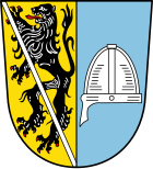
The description of the coat of arms reads: “Split of gold and blue; in front a red armored black lion covered with a silver sloping bar, behind a silver helmet with nose protection. "
The Bamberg lion stands for the rule of the bishopric of Bamberg over Litzendorf, the helmet for the ministerials of Litzendorf, who were active in the 12th century when there were no coats of arms.
Infrastructure
Breweries
In the community there are the five breweries Hölzlein and Reh in Lohndorf , Knoblach in Schammelsdorf , Hönig in Tiefenellern and the Brandholz brewery in Melkendorf. The Winkler breweries in Melkendorf and Hummel in Litzendorf brewed until the end of 2015 and 1978, respectively.
Voluntary fire brigades
In the districts of Litzendorf, Lohndorf, Melkendorf, Naisa, Pödeldorf, Schammelsdorf and Tiefenellern, there are separate volunteer fire departments .
Attractions

|
St. Wenceslas | The baroque parish church of St. Wenceslas in Litzendorf was built from 1715 to 1718 by the builder Johann Dientzenhofer . It consists of bright golden-yellow iron sandstone blocks and can be seen from afar. |

|
Virgin Mary's birth | The parish church of the Birth of Mary in Lohndorf also consists of golden-yellow iron sandstone blocks and can be seen from afar. |

|
Franconian Street of Sculptures | The Franconian Street of Sculptures between the villages of Tiefenellern, Lohndorf and Litzendorf was created in 1994 and is an exhibition of sculptures in the middle of the landscape of the Ellertal . |

|
Melkendorf singing memorial | The Melkendorf singing memorial for the dead and fallen of the Franconian Singing Association was erected in 1963 on a hill above Melkendorf. The memorial consists of twelve circular limestone columns and an altar-like sarcophagus. In the memorial stone there are memorial books with the names of the deceased of all choral societies of the then twelve, now thirteen singing groups. |

|
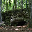
Maiden cave | The Jungfernhöhle near Tiefenellern is a Neolithic site. Excavations have provided evidence of the use of the cave by four Neolithic and almost all subsequent cultures. The name Jungfernhöhle comes from the fact that mostly the remains of women were found there. |

|
Art and reflection path | The art and reflection path is a 3.3 km long sculpture path between Litzendorf, Lohndorf and Melkendorf , on which a total of 18 different works of art are displayed. |

|
Burial mound cemetery near Litzendorf | On the road from Litzendorf to Geisfeld there are early Celtic barrows. The group of hills is completely surrounded by forest. The diameter of the burial mounds varies between eight and 25 meters. During excavations in the 19th century, material from the Bronze Age and the Early Iron Age was found. |
Architectural monuments in Litzendorf
Personalities
- Günther Denzler (* 1948), former district administrator (1996–2014) and incumbent district council president of the administrative district of Upper Franconia, lives in the Pödeldorf district
- Wolfgang Heyder (* 1956), long-time managing director of the professional gaming company Franken 1st and SPD politician in the Bamberg district council , lives in the Pödeldorf district
- Günter Wojaczek (1932–1997), classical philologist and local councilor in Pödeldorf (before being incorporated into Litzendorf), lived in the Pödeldorf district from 1971 until his death
Individual evidence
- ↑ "Data 2" sheet, Statistical Report A1200C 202041 Population of the municipalities, districts and administrative districts 1st quarter 2020 (population based on the 2011 census) ( help ).
- ^ Litzendorf community in the local database of the Bavarian State Library Online . Bavarian State Library
- ↑ Handbook of Bavarian History, Vol. 1: The old Bavaria. The tribal duchy until the end of the 12th century, ed. by Max Spindler, 2nd ed., Munich 1981, pp. 113-114.
- ^ Federal Statistical Office (ed.): Historical municipality directory for the Federal Republic of Germany. Name, border and key number changes in municipalities, counties and administrative districts from May 27, 1970 to December 31, 1982 . W. Kohlhammer GmbH, Stuttgart / Mainz 1983, ISBN 3-17-003263-1 , p. 673 .
- ↑ Brandholz Brewery . In: brandholz-brauerei.de . Retrieved January 12, 2020
- ↑ . Winkler Brewery ( Memento from January 8, 2016 in the Internet Archive )
Web links
- Franconian Switzerland
- www.litzendorf.de
- Litzendorf near Foracheim
- Entry on the coat of arms of Litzendorf in the database of the House of Bavarian History
- Litzendorf: Official statistics of the LfStat (PDF; 1.24 MB)
- Litzendorf in the location database of the Bavarian State Library Online . Bavarian State Library


