
Pommersfelden
| coat of arms | Germany map | |
|---|---|---|

|
Coordinates: 49 ° 46 ' N , 10 ° 49' E |
|
| Basic data | ||
| State : | Bavaria | |
| Administrative region : | Upper Franconia | |
| County : | Bamberg | |
| Height : | 270 m above sea level NHN | |
| Area : | 35.7 km 2 | |
| Residents: | 3058 (Dec. 31, 2019) | |
| Population density : | 86 inhabitants per km 2 | |
| Postal code : | 96178 | |
| Primaries : | 09548, 09502 | |
| License plate : | BA | |
| Community key : | 09 4 71 172 | |
| LOCODE : | DE PMF | |
| Community structure: | 11 parts of the community | |
| Address of the municipal administration: |
Hauptstrasse 11 96178 Pommersfelden |
|
| Website : | ||
| Mayor : | Gerd Dallner (FWGS) | |
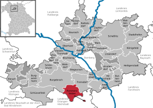
| Location of the municipality of Pommersfelden in the Bamberg district | ||
  |
||

Pommersfelden (East Franconian Bummerschfelln ) is a municipality in the Upper Franconian district of Bamberg .
geography
Geographical location
The community lies on the edge of the Steigerwald Nature Park . The Reiche Ebrach flows through the municipality in a northwest direction.
Neighboring communities
Neighboring communities are (clockwise, starting in the north): Burgebrach , Frensdorf (both districts of Bamberg), Höchstadt an der Aisch and Mühlhausen (both districts of Erlangen-Höchstadt , Middle Franconia ). Thanks to two exclaves , the community also shares a border with the Adelsdorf community (also Erlangen-Höchstadt district).
Community structure
The municipality has eleven officially named parts of the municipality (the type of settlement and the number of inhabitants as of December 31, 2018 are given in brackets ):
|
|
There is also the currently uninhabited wasteland Weichhaus .
There are the districts of Oberndorf with Weiher and Ziegelhütte, Pommersfelden with Limbach, Steppach with Stolzenroth and Unterköst, Sambach with Schweinbach and Wind. South-east of the municipality are two closely spaced exclaves at Limbacher Weiher and Steinersee within the municipality of Adelsdorf.

history

Until the church is planted
The place was first mentioned in 1297 as "Wumarsuelden". The place was named after the personal name of the founder Uuinimar, Wonamar . It was first called "Pomersvelden" in 1319/1320. Pommersfelden has been owned by the Truchsess von Pommersfelden since the 14th century . In 1349 Heinrich Truchseß donated the church of St. Maria and Johannes and received the associated patronage . The place, which previously belonged to the Seussling parish , became independent under canon law at the same time.
With the death of Friedrich Ernst Truchseß von Pommersfelden on April 21, 1710, this noble family died out. In his will, Friedrich Ernst appointed Elector Lothar Franz von Schönborn ( Archbishop of Mainz and Prince-Bishop of Bamberg ) as a universal heir .
At the end of the 18th century there were 81 properties in Pommersfelden. The high court exercised the Schönborn rule in Pommersfelden. If necessary, it had to be delivered to the Bamberg center in Bechhofen . The rulership of Pommersfelden held the village and community rulership. The landlords were the lordship of Pommersfelden (castle, mill, brewery, sheep farm, 3 taverns, 1 bath room, 1 forge, 2 courtyards, 1 third courtyard, 2 estates, 2 estates, 32 Sölden , 20 drip houses , 8 houses) and the parish Pommersfelden (rectory , 1 drip house). Two houses and a shepherd's house were buildings used by the community.
The rule of the Counts of Schönborn, who were also members of the Franconian Knight Circle, came to Bavaria with the Rhine Federation Act in 1806 . As part of the community edict which was tax district Pommersfelden made to the Limbach and Weissenstein Castle belonged. With the second community edict (1818) the rural community of Pommersfelden was formed, which was congruent with the tax district. In administration and jurisdiction it was subordinate to the regional court of Höchstadt and in financial administration to the Rent Office of Höchstadt . In the voluntary jurisdiction, the entire community was subject to the Pommersfelden Patrimonial Court (until 1848). From 1862 Pommersfelden was administered by the district office of Höchstadt an der Aisch (renamed the district of Höchstadt an der Aisch in 1938 ) and continued to be administered by the Rentamt Höchstadt (1920–1929: Finanzamt Höchstadt , from 1929: Finanzamt Forchheim ). The jurisdiction remained with the district court of Höchstadt until 1879, 1880–1959 district court of Höchstadt , from 1959 district court of Forchheim . The municipality originally had an area of 10.777 km².
District affiliation
Until June 30, 1972 Pommersfelden belonged to the dissolved district of Höchstadt an der Aisch .
Incorporations
Today's municipality of Pommersfelden emerged as part of the Bavarian regional reform on May 1, 1978 from the formerly independent municipalities of Oberndorf, Pommersfelden, Sambach and Steppach.
Administrative community
From May 1978 to December 1979, Pommersfelden was part of the Frensdorf administrative community . This administrative community with the other member communities Frensdorf and Pettstadt was dissolved on January 1, 2002.
Population development
In the period from 1988 to 2018, the municipality grew from 2,270 to 3,063 by 793 inhabitants or 34.9%.
Pommersfelden community
| year | 1840 | 1852 | 1861 | 1867 | 1871 | 1875 | 1880 | 1885 | 1890 | 1895 | 1900 | 1905 | 1910 | 1919 | 1925 | 1933 | 1939 | 1946 | 1950 | 1961 | 1970 | 1987 | 1995 | 2005 | 2010 | 2017 |
|---|---|---|---|---|---|---|---|---|---|---|---|---|---|---|---|---|---|---|---|---|---|---|---|---|---|---|
| Residents | 760 | 783 | 730 | 723 | 724 | 725 | 733 | 722 | 690 | 650 | 624 | 605 | 650 | 633 | 650 | 654 | 614 | 981 | 943 | 658 | 608 | 2253 | 2561 | 2920 | 2946 | 2988 |
| Houses | 135 | 126 | 131 | 120 | 129 | 128 | 576 | 861 | ||||||||||||||||||
| source |
Part of the municipality Pommersfelden
| year | 1827 | 1861 | 1871 | 1885 | 1900 | 1925 | 1950 | 1961 | 1970 | 1987 | 2018 |
|---|---|---|---|---|---|---|---|---|---|---|---|
| Residents | 394 | 522 | 525 | 503 | 424 | 484 * | 740 * | 531 * | 433 | 441 | 682 * |
| Houses | 90 | 92 | 91 * | 102 * | 101 * | 133 | |||||
| source |
religion
According to the census on May 9, 2011, 51.6% of the population are Roman Catholic and 37.3% Evangelical Lutheran. 11.1% have another religion or are non-denominational.
politics
Municipal council
The municipal council comprises 16 (previously 14) members, who are distributed among the individual voter communities as follows:
| Community of voters | Seats 2002-2008 | Seats 2008-2014 | Seats 2014-2020 | Seats 2020–2026 |
|---|---|---|---|---|
| Voter block Sambach (WBS) | 5 | 5 | 5 | 4th |
| Free Voting Community Steppach (FWGS) | 5 | 4th | 5 | 6th |
| Citizens' Block Pommersfelden (BBP) | 3 | 3 | 3 | 3 |
| Unity Limbach (EL) | 1 | 1 | 1 | 2 |
| Local community Oberndorf - Weiher (OGOW) | not participated | not participated | not participated | 1 |
| Common Citizens List - FDP (GBL - FDP) | 0 | 1 | 0 | not participated |
mayor
Mayor of the municipality of Pommersfelden has been Gerd Dallner (FWGS) since May 1, 2020, who received 76.41% of the votes in one of the opposing candidates. He is the successor to Hans Beck from the Sambach electoral bloc, who has been in office since 1996 and was re-elected in 2008 and 2014 with 66 percent of the vote. Beck's predecessor was Erwin Ruhl from 1972 to 1996.
badges and flags
The municipality of Pommersfelden has had a coat of arms since 1985.
|
|
Blazon : “ Divided ; above in silver a blue pole , which is covered with the silver capital letter T, each side with a red pinnacle tower, below in red on three lowered silver tips striding a blue crowned and armored double-tailed golden lion . "
Yellow and red municipal flag |
| Foundation of the coat of arms: Since 1978, Pommersfelden has consisted of the formerly independent communities of Pommersfelden, Steppach, Oberndorf and Sambach. The lion and the colors red, silver and blue are taken from the coat of arms of the Truchsessen of Pommersfelden , who were wealthy in the village from the 14th century. The T-Cross, also known as the Antonius Cross, represents the town of Sambach, whose church is dedicated to St. Antonius. The two tin towers are taken from the coat of arms of the municipality of Steppach. They represent all former and still existing castles in the municipality. |
economy
traffic

The national road 2263 goes to southeast Limbach over to a connection point of the state road 505 or the north-west State Street 2260 crossing according Steppach and further to Unterneuses to bundesstraße 22 . A community road runs northeast to the BA 24 district road when there is wind . Another community connecting road runs southeast to State Road 2254 between Zentbechhofen in the northeast and Höchstadt in the southwest.
In the south of the municipality, the federal motorway 3 runs with junction 79 (Pommersfelden). To the south you can reach the cities of Erlangen and Nuremberg via the motorway , while Würzburg is the next city to the west . From the Pommersfelden junction, the 505 federal road leads to Bamberg, around twenty kilometers away .
The Frensdorf – Schlüsselfeld railway runs through the municipality , on which only goods have been transported since passenger traffic was discontinued in 1977.
Voluntary fire brigades
In the municipality of Pommersfelden there are volunteer fire brigades in Oberndorf / Weiher, Pommersfelden / Limbach, Sambach and Steppach.
Breweries
The Hennemann brewery in Sambach is the only remaining brewery in the municipality. The Schlossbrauerei Dorn brewed in Pommersfelden until 1979, and the Seubert brewery in Steppach until 1975. The Hofmann Grüner Baum brewery in Pommersfelden ceased brewing in 1985.
Culture and sights
Buildings

In the south of the village of Pommersfelden stands - as a separate district - the Weißenstein Castle , built by Lothar Franz von Schönborn from 1711 to 1716 , which is owned by the family. The baroque palace houses an impressive staircase, a garden hall grotto and a collection of paintings that is well worth seeing.
In the center of Pommersfelden are the remains of a former moated castle and in Sambach there is a Jesuit castle . Both are not open to the public. There are churches in the localities of Limbach, Pommersfelden, Sambach and Steppach.
Parks
Weissenstein Castle has an English landscape park from the 19th century.
Others
In 2013, black storks nested and brooded in Steppach near a white stork nest that was also occupied . This fact is remarkable because the disturbance-sensitive black storks usually avoid human settlements and breed in forests.
Sons and daughters of the church
- Joseph Dorn (born August 12, 1759 in Kratz-Sambach, today's Sambach; † August 6, 1841 in Bamberg), painter, restorer and gallery inspector. From 1802 he was an inspector at the gallery of Weissenstein Castle.
- Konrad Beyer (born July 13, 1834 - † March 17, 1906 in Mainz), writer and poet
- Robert Sauer (born September 16, 1898; † August 22, 1970 in Munich), mathematician, Rector of the Technical University of Munich and President of the Bavarian Academy of Sciences
literature
- Johann Kaspar Bundschuh : Pommersfelden . In: Geographical Statistical-Topographical Lexicon of Franconia . tape 4 : Ni-R . Verlag der Stettinische Buchhandlung, Ulm 1801, DNB 790364301 , OCLC 833753101 , Sp. 379-380 ( digitized version ).
- Georg Daßler (Ed.): District of Höchstadt ad Aisch. Past and present . Verl. F. Authorities and Wirtschaft Hoeppner, Aßling-Munich 1970, DNB 457004320 , p. 111-115 .
- Hanns Hubert Hofmann : Höchstadt-Herzogenaurach (= Historical Atlas of Bavaria, part Franconia . I, 1). Commission for Bavarian State History, Munich 1951, DNB 452071143 , p. 78 ( digitized version ). Ibid. S. 134 ( digitized version ).
- Hanns Hubert Hofmann : Pommersfelden. In: Karl Bosl (Hrsg.): Handbook of the historical sites of Germany . Volume 7: Bavaria (= Kröner's pocket edition . Volume 277). 3. Edition. Kröner, Stuttgart 1981, ISBN 3-520-27703-4 , p. 591 f.
- Wolf-Armin von Reitzenstein : Lexicon of Franconian place names. Origin and meaning . Upper Franconia, Middle Franconia, Lower Franconia. CH Beck, Munich 2009, ISBN 978-3-406-59131-0 , p. 178 .
- Georg Spath: The last Truchsesse from Pommersfelden. Oscar Dennhardt publishing house, Höchstadt an der Aisch 1936.
- Pleikard Joseph Stumpf : Pommersfelden . In: Bavaria: a geographical-statistical-historical handbook of the kingdom; for the Bavarian people . Second part. Munich 1853, p. 592 ( digitized version ).
Web links
- Pommersfelden in the Topographia Franconiae of the University of Würzburg , accessed on October 24, 2019.
- Pommersfelden: Official statistics of the LfStat (PDF; 1.2 MB)
Individual evidence
- ↑ "Data 2" sheet, Statistical Report A1200C 202041 Population of the municipalities, districts and administrative districts 1st quarter 2020 (population based on the 2011 census) ( help ).
- ^ Community Pommersfelden in the local database of the Bavarian State Library Online . Bayerische Staatsbibliothek, accessed on October 24, 2019.
- ↑ Population figures
- ↑ Official topographic map of Bavaria Atlas. Accessed June 24, 2019 (German).
- ↑ W.-A. v. Reitzenstein, p. 178.
- ↑ HH Hofmann, p. 78.
- ↑ HH Hofmann, p. 134.
- ↑ a b c Bavarian State Statistical Office (ed.): Official city directory for Bavaria, territorial status on October 1, 1964 with statistical information from the 1961 census . Issue 260 of the articles on Bavaria's statistics. Munich 1964, DNB 453660959 , Section II, Sp. 681 ( digitized version ).
- ^ Federal Statistical Office (ed.): Historical municipality directory for the Federal Republic of Germany. Name, border and key number changes in municipalities, counties and administrative districts from May 27, 1970 to December 31, 1982 . W. Kohlhammer, Stuttgart / Mainz 1983, ISBN 3-17-003263-1 , p. 673 .
- ↑ Dismissal by law of August 10, 1979 (GVBl p. 223)
- ↑ Sixth law amending the structure of municipalities and administrative communities of November 23, 2001 (GVBl p. 738)
- ↑ a b Only inhabited houses are given, designated as residential buildings from 1871 to 2017 .
- ↑ a b c d e f g h i j k l m Bavarian State Statistical Office (Hrsg.): Historical municipality register: The population of the municipalities of Bavaria from 1840 to 1952 (= contributions to Statistics Bavaria . Issue 192). Munich 1954, DNB 451478568 , p. 146 , urn : nbn: de: bvb: 12-bsb00066439-3 ( digitized version ).
- ↑ a b Joseph Heyberger, Chr. Schmitt, v. Wachter: Topographical-statistical manual of the Kingdom of Bavaria with an alphabetical local dictionary . In: K. Bayer. Statistical Bureau (Ed.): Bavaria. Regional and folklore of the Kingdom of Bavaria . tape 5 . Literary and artistic establishment of the JG Cotta'schen Buchhandlung, Munich 1867, Sp. 874 , urn : nbn: de: bvb: 12-bsb10374496-4 ( digitized version ).
- ↑ a b Kgl. Statistical Bureau (ed.): Complete list of localities of the Kingdom of Bavaria. According to districts, administrative districts, court districts and municipalities, including parish, school and post office affiliation ... with an alphabetical general register containing the population according to the results of the census of December 1, 1875 . Adolf Ackermann, Munich 1877, 2nd section (population figures from 1871, cattle figures from 1873), Sp. 1046 , urn : nbn: de: bvb: 12-bsb00052489-4 ( digital copy ).
- ↑ a b K. Bayer. Statistical Bureau (Ed.): Localities directory of the Kingdom of Bavaria. According to government districts, administrative districts, ... then with an alphabetical register of locations, including the property and the responsible administrative district for each location. LIV. Issue of the contributions to the statistics of the Kingdom of Bavaria. Munich 1888, Section III, Sp. 991-992 ( digitized version ).
- ↑ a b K. Bayer. Statistical Bureau (Ed.): Directory of localities of the Kingdom of Bavaria, with alphabetical register of places . LXV. Issue of the contributions to the statistics of the Kingdom of Bavaria. Munich 1904, Section II, Sp. 1040 ( digitized version ).
- ↑ a b Bavarian State Statistical Office (ed.): Localities directory for the Free State of Bavaria according to the census of June 16, 1925 and the territorial status of January 1, 1928 . Issue 109 of the articles on Bavaria's statistics. Munich 1928, Section II, Sp. 1074 ( digitized version ).
- ↑ a b Bavarian State Statistical Office (ed.): Official place directory for Bavaria - edited on the basis of the census of September 13, 1950 . Issue 169 of the articles on Bavaria's statistics. Munich 1952, DNB 453660975 , Section II, Sp. 925 ( digitized version ).
- ↑ a b Bavarian State Statistical Office (Hrsg.): Official local directory for Bavaria . Issue 335 of the articles on Bavaria's statistics. Munich 1973, DNB 740801384 , p. 147 ( digitized version ).
- ↑ a b Bavarian State Office for Statistics and Data Processing (Ed.): Official local directory for Bavaria, territorial status: May 25, 1987 . Issue 450 of the articles on Bavaria's statistics. Munich November 1991, DNB 94240937X , p. 290 ( digitized version ).
- ↑ a b LfStat : Pommersfelden: Official statistics. In: statistik.bayern.de. Pp. 6 and 12 , accessed on October 17, 2019 .
- ^ Karl Friedrich Hohn (Ed.): Geographical-statistical description of the Upper Main district . J. Dederich, Bamberg 1827, p. 133 ( digitized version ).
- ↑ Our community and its districts on the website pommersfelden.de
- ^ Entry on the coat of arms of Pommersfelden in the database of the House of Bavarian History
- ↑ Pommersfelden. In: Kommunalflaggen.eu. Retrieved July 7, 2020 .
Limbach | Oberndorf | Pommersfelden | Sambach | Weißenstein Castle | Schweinbach | Steppach | Stolzenroth | Food | Soft house | Pond | wind

Altendorf | Baunach | Bischberg | Breitengüßbach | Burgebrach | Burgwindheim | Buttenheim | Ebrach | Frensdorf | Gerach | Gundelsheim | Hallstadt | Heiligenstadt in Upper Franconia | Hirschaid | Kemmern | Koenigsfeld | Louder | Lisberg | Litzendorf | Memmelsdorf | Oberhaid | Pettstadt | Pommersfelden | Priesendorf | Rattelsdorf | Reckendorf | Scheßlitz | Key field | Schönbrunn im Steigerwald | Stadelhofen | Stegaurach | Strullendorf | Viereth-Trunstadt | Walsdorf | Wattendorf | Zapfendorf
Community-free areas
Ebracher Forst |
Eichwald |
Geisberger Forest |
Main Bog Forest |
Koppenwinder Forest |
Lindach |
Semberg |
Steinachsrangen |
Winkelhofer Forest |
Zückshuter Forest