
Steppach (Pommersfelden)
|
Steppach
Community Pommersfelden
|
|
|---|---|
.jpg) |
|
| Height : | 268–290 m above sea level NHN |
| Residents : | 1043 (December 31, 2018) |
| Incorporation : | May 1, 1978 |
| Postal code : | 96178 |
| Area code : | 09548 |
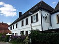
_001.JPG) Place view
|
|


Steppach is a district of the municipality of Pommersfelden in the Upper Franconian district of Bamberg .
geography
The Stöckleinsbach flows through the parish village and feeds the Märzensee lake to the northwest of the village and flows into the Ebrach empire as a left tributary near Pommersfelden . The place is immediately surrounded by arable land and grassland. In the southeast the corridor is called Stockig , in the south Au . The Köster Berg ( 315 m above sea level ) rises about one kilometer to the west in the Weidach forest area .
Neighboring towns are Weiher and Oberndorf in the east, Pommersfelden in the south, Stolzenroth in the south-west and Unterköst in the north-west (all Pommersfelden municipality).
history
Steppach was first mentioned in a document in 1000 in the Fulda tradition notes. The place is likely to have arisen only in the 10th century during the declining Frankish colonization. The place name means to the steadily flowing stream . The Würzburg bishopric was the original feudal lord . In 1093 the Lords of Stetebach were mentioned, who belonged to the Ministerial Association of the Counts of Abenberg . They had a free self in and were Bishopric of Bamberg connected. At the end of the 13th century, the Stetebach were extinct. The burgraviate of Nuremberg , and in their successor the margraves , were feudal lords. In 1422 the Lords of Cratz appeared as their fiefdoms . The margravial office of Liebenau-Steppach had to sell Margrave Georg Wilhelm on July 1, 1721 because of excessive indebtedness. It was purchased for 72,000 florins from the Counts of Schönborn .
Towards the end of the 18th century there were 69 properties and a community shepherd's house in Steppach. The high court and the village and community rulership exercised the Schönborn rule of Pommersfelden . The landlords were the Pommersfelden rulership (inn, 2 breweries, bathing room, 3 estates, 17 Sölden , 9 stalactites , 8 houses), the Bamberg Monastery ( Sambach administration : 4 Gülthöfe, 12 Sölden, 2 stalactites; Bamberg cathedral chapter: 1 mill, 1 estate , 2 houses; Kastenamt Schlüsselau : 2 Gütlein) and the parish of Steppach (3 houses).
In 1802 the Bamberg estates came from Steppach to Bavaria , and in 1806 those of the Pommersfelden rulership. As part of the municipal edict , the Steppach tax district was formed in 1808 , to which Stolzenroth and Unterköst belonged. In the same year, the rural community Steppach was formed, which was congruent with the tax district. In administration and jurisdiction it was subordinate to the regional court of Höchstadt and in financial administration to the Rent Office of Höchstadt . In the voluntary jurisdiction and the local police, 42 properties were subordinate to the Pommersfelden Patrimonial Court (until 1848). From 1862 Steppach was administered by the district office of Höchstadt an der Aisch (renamed the district of Höchstadt an der Aisch in 1938 ) and continued by the Rentamt Höchstadt (1920–1929: Finanzamt Höchstadt , from 1929: Finanzamt Forchheim ). The jurisdiction remained with the district court of Höchstadt until 1879, 1880–1959 district court of Höchstadt , from 1959 district court of Forchheim . The municipality had an area of 11.809 km².
Until June 30, 1972 Steppach belonged to the district of Höchstadt an der Aisch . The municipality of Steppach was incorporated into the municipality of Pommersfelden on May 1, 1978 as part of the regional reform in Bavaria .
Population development
Steppach municipality
| year | 1827 | 1840 | 1852 | 1855 | 1861 | 1867 | 1871 | 1875 | 1880 | 1885 | 1890 | 1895 | 1900 | 1905 | 1910 | 1919 | 1925 | 1933 | 1939 | 1946 | 1950 | 1952 | 1961 | 1970 |
|---|---|---|---|---|---|---|---|---|---|---|---|---|---|---|---|---|---|---|---|---|---|---|---|---|
| Residents | 540 | 625 | 568 | 567 | 569 | 597 | 605 | 589 | 628 | 617 | 572 | 560 | 551 | 552 | 561 | 548 | 553 | 511 | 512 | 760 | 769 | 740 | 575 | 637 |
| Houses | 102 | 105 | 102 | 102 | 106 | 114 | ||||||||||||||||||
| source |
Place Steppach
| year | 1827 | 1861 | 1871 | 1885 | 1900 | 1925 | 1950 | 1961 | 1970 | 1987 | 2018 |
|---|---|---|---|---|---|---|---|---|---|---|---|
| Residents | 370 | 386 | 411 | 431 | 381 | 386 | 575 | 434 | 519 | 691 | 1043 |
| Houses | 73 | 72 | 74 | 78 | 86 | 171 | |||||
| source |
coat of arms
The community had a coat of arms since November 28, 1958.
Blazon : About of silver and black gevierten sign foot in blue next to each other three silver square towers with red-roofed battlements.
Description of the coat of arms: The three towers represent the three former castles Steppach, Stolzenroth and Liebenau. An office of the Zollerischen Burgraves of Nuremberg and later Margraves of Brandenburg-Kulmbach was named after the latter, whose seat was the village of Steppach. That is why the fourth shield of the Zollern appears in the municipal coat of arms. The main colors silver and blue indicate the colors of the tribe coat of arms of the Truchseß von Pommersfelden , who once had the most important manorial rule in the place.
religion
The place has been predominantly Protestant since the Reformation and parish to St. Erhard (Steppach) . The Catholics are parish after St. Antonius Abbas (Sambach) .
Worth seeing

Former forester's house

Small farm
Rectory

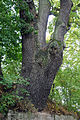
Vollandseiche on beer cellar
Trunk on wall

Parish Church of St. Erhard


Architectural monuments
- House number 39: wrought iron bracket and inscription plaque
- House No. 50: Former forester's house
- House No. 62: Former Amberger inn
- House number 65, 65a: small farm
- House number 66: residential building with barn
- House number 70: rectory
- House number 72: Evangelical Lutheran parish church of St. Erhard
- House number 85: farmhouse
- Stone cross
Vollandseiche
With a chest height of 7.50 m (2016). The pedunculate oak , protected as a natural monument , stands directly above a beer cellar built by A.Volland in the 19th century.
traffic

The national road 2260 goes according to pride Roth (1.4 km south west) or after Oberdorf (1.3 km northeast). The state road 2263 runs to Untereuses to the federal road 22 (6.5 km north) or to Pommersfelden (1.1 km south-east). A little north of Steppach, the BA 45 district road branches off from the St 2263 to Unterköst (1.1 km northwest).
The Steppach-Pommersfelden stop is on the Strullendorf – Schlüsselfeld railway line , which has been used almost exclusively for rail freight transport since 1977 .
Personalities
- Kerstin Hack (* 1967), English studies specialist, ethnologist, author, publisher and speaker (grew up in Steppach)
literature
- Johann Kaspar Bundschuh : Steppach . In: Geographical Statistical-Topographical Lexicon of Franconia . tape 5 : S-U . Verlag der Stettinische Buchhandlung, Ulm 1802, DNB 790364328 , OCLC 833753112 , Sp. 440-441 ( digitized version ).
- Georg Daßler (Ed.): District of Höchstadt ad Aisch. Past and present . Verl. F. Authorities and Wirtschaft Hoeppner, Aßling-Munich 1970, DNB 457004320 , p. 125-127 .
- Hanns Hubert Hofmann : Höchstadt-Herzogenaurach (= Historical Atlas of Bavaria, part Franconia . I, 1). Commission for Bavarian State History, Munich 1951, DNB 452071143 , p. 84 ( digitized version ). Ibid. S. 136 ( digitized version ).
- Pleikard Joseph Stumpf : Steppach . In: Bavaria: a geographical-statistical-historical handbook of the kingdom; for the Bavarian people . Second part. Munich 1853, p. 593 ( digitized version ).
Web links
- steppach-oberfranken.de
- Districts on the website pommersfelden.de
- Steppach in the location database of the Bayerische Landesbibliothek Online . Bayerische Staatsbibliothek, accessed on October 24, 2019.
- Steppach in the Topographia Franconiae of the University of Würzburg , accessed on October 24, 2019.
- Steppach in the historical directory of the Association for Computer Genealogy , accessed on October 24, 2019
Individual evidence
- ↑ a b Our community and its districts on the website pommersfelden.de
- ↑ a b Steppach in the Bavaria Atlas
- ↑ G. Daßler (Ed.), Pp. 125f.
- ↑ HH Hofmann, p. 84.
- ↑ HH Hofmann, p. 136.
- ↑ a b c Bavarian State Statistical Office (ed.): Official city directory for Bavaria, territorial status on October 1, 1964 with statistical information from the 1961 census . Issue 260 of the articles on Bavaria's statistics. Munich 1964, DNB 453660959 , Section II, Sp. 681-682 ( digitized version ).
- ^ Federal Statistical Office (ed.): Historical municipality directory for the Federal Republic of Germany. Name, border and key number changes in municipalities, counties and administrative districts from May 27, 1970 to December 31, 1982 . W. Kohlhammer, Stuttgart / Mainz 1983, ISBN 3-17-003263-1 , p. 673 .
- ↑ a b Only inhabited houses are given. From 1871 to 1987 they are called residential buildings .
- ^ A b Karl Friedrich Hohn (Hrsg.): Geographical-statistical description of the Upper Main district . J. Dederich, Bamberg 1827, p. 134 ( digitized version ). For the municipality of Steppach plus the residents of Stolzenroth (p. 134) and Unterköst (p. 134). For Steppach, 3701 inhabitants are incorrectly given.
- ↑ a b c d e f g h i j k l m n o Bavarian State Statistical Office (Hrsg.): Historical municipality register: The population of the municipalities of Bavaria from 1840 to 1952 (= contributions to Statistics Bavaria . Issue 192). Munich 1954, DNB 451478568 , p. 146 , urn : nbn: de: bvb: 12-bsb00066439-3 ( digitized version ).
- ↑ a b Joseph Heyberger, Chr. Schmitt, v. Wachter: Topographical-statistical manual of the Kingdom of Bavaria with an alphabetical local dictionary . In: K. Bayer. Statistical Bureau (Ed.): Bavaria. Regional and folklore of the Kingdom of Bavaria . tape 5 . Literary and artistic establishment of the JG Cotta'schen Buchhandlung, Munich 1867, Sp. 875 , urn : nbn: de: bvb: 12-bsb10374496-4 ( digitized version ).
- ↑ a b Kgl. Statistical Bureau (ed.): Complete list of localities of the Kingdom of Bavaria. According to districts, administrative districts, court districts and municipalities, including parish, school and post office affiliation ... with an alphabetical general register containing the population according to the results of the census of December 1, 1875 . Adolf Ackermann, Munich 1877, 2nd section (population figures from 1871, cattle figures from 1873), Sp. 1047 , urn : nbn: de: bvb: 12-bsb00052489-4 ( digitized ).
- ↑ a b K. Bayer. Statistical Bureau (Ed.): Localities directory of the Kingdom of Bavaria. According to government districts, administrative districts, ... then with an alphabetical register of locations, including the property and the responsible administrative district for each location. LIV. Issue of the contributions to the statistics of the Kingdom of Bavaria. Munich 1888, Section III, Sp. 992 ( digitized version ).
- ↑ a b K. Bayer. Statistical Bureau (Ed.): Directory of localities of the Kingdom of Bavaria, with alphabetical register of places . LXV. Issue of the contributions to the statistics of the Kingdom of Bavaria. Munich 1904, Section II, Sp. 1041 ( digitized version ).
- ↑ a b Bavarian State Statistical Office (ed.): Localities directory for the Free State of Bavaria according to the census of June 16, 1925 and the territorial status of January 1, 1928 . Issue 109 of the articles on Bavaria's statistics. Munich 1928, Section II, Sp. 1074 ( digitized version ).
- ↑ a b Bavarian State Statistical Office (ed.): Official place directory for Bavaria - edited on the basis of the census of September 13, 1950 . Issue 169 of the articles on Bavaria's statistics. Munich 1952, DNB 453660975 , Section II, Sp. 926 ( digitized version ).
- ↑ a b Bavarian State Statistical Office (Hrsg.): Official local directory for Bavaria . Issue 335 of the articles on Bavaria's statistics. Munich 1973, DNB 740801384 , p. 147 ( digitized version ).
- ↑ Bavarian State Office for Statistics and Data Processing (Ed.): Official local directory for Bavaria, territorial status: May 25, 1987 . Issue 450 of the articles on Bavaria's statistics. Munich November 1991, DNB 94240937X , p. 290 ( digitized version ).
- ^ Entry in the directory of monumental oaks . Retrieved August 1, 2020

Limbach | Oberndorf | Pommersfelden | Sambach | Weißenstein Castle | Schweinbach | Steppach | Stolzenroth | Food | Soft house | Pond | wind