
Mühlhausen (Middle Franconia)
| coat of arms | Germany map | |
|---|---|---|

|
Coordinates: 49 ° 45 ' N , 10 ° 46' E |
|
| Basic data | ||
| State : | Bavaria | |
| Administrative region : | Middle Franconia | |
| County : | Erlangen-Höchstadt | |
| Management Community : | Höchstadt an der Aisch | |
| Height : | 275 m above sea level NHN | |
| Area : | 16.59 km 2 | |
| Residents: | 1783 (Dec. 31, 2019) | |
| Population density : | 107 inhabitants per km 2 | |
| Postal code : | 96172 | |
| Area code : | 09548 | |
| License plate : | ERH, HÖS | |
| Community key : | 09 5 72 143 | |
| Market structure: | 6 parts of the community | |
Market administration address : |
Main street 2 96172 Mühlhausen |
|
| Website : | ||
| Mayor : | Klaus Faatz (CSU) | |
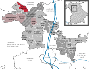
| Location of the Mühlhausen market in the Erlangen-Höchstadt district | ||
  |
||

Mühlhausen is a market in the Middle Franconian district of Erlangen-Höchstadt and a member of the administrative community of Höchstadt an der Aisch .
geography
Geographical location
Mühlhausen is located southwest of Bamberg on the Reichen Ebrach .
Neighboring communities
Neighboring communities are (starting in the north clockwise): Burgebrach , Pommersfelden , Höchstadt an der Aisch , Lonnerstadt , Wachenroth , Schlüsselfeld .
Community structure
The municipality has six officially named districts :
- Decheldorf
- Lempenmühle
- Mulhouse
- Neumühle
- Schirnsdorf
- Simmersdorf
history
Until the church is planted
The place was first mentioned in 1008 as "Mulinhusun". The basic word of the place name is a plural form of the Old High German word hûs (= house), the defining word is mulîn (mill). Accordingly, the place name means houses near a mill .
The Mühlhausen market was ruled before 1800 and belonged to the Barons von Egloffstein , who belonged to the knight canton of Steigerwald of the Franconian knight circle.
At the end of the 18th century there were 103 properties in Mühlhausen. The high court exercised the Bamberg center Wachenroth . The manor Mühlhausen ruled the village and community . The landlords were the bishopric of Bamberg (Kastenamt Wachenroth: church, 1 Halbhof, 5 Sölden , 1 mill, 1 brewery and tavern, 2 houses, 2 little houses; Kastenamt Schlüsselau : 1 Sölde), the Schwarzenbergischer Kastenamt Markt Scheinfeld (3 estates), the Schönborn'sche Herrschaft Pommersfelden (6 Sölden, 2 semi-estates, 2 semi-estates, 2 drip houses , 2 half drip houses, 2 houses, 1 mill), the manor Mühlhausen (castle, 2 taverns, sheep farm, forge, mill, 10 estates, 14 estates, 38 houses).
With the Rheinbund act 1806 the place came to Bavaria . As part of the municipal edict , the tax district Mühlhausen was formed in 1808 , to which Decheldorf , Neumühle and Simmersdorf belonged. In the same year the rural community Mühlhausen was formed, which was congruent with the tax district. In administration and jurisdiction it was subordinate to the regional court of Höchstadt and in financial administration to the Rent Office of Höchstadt . In voluntary jurisdiction, 89 properties were subordinate to the Patrimonial Court of Mühlhausen (until 1837), 23 properties to the PG Pommersfelden (until 1848) and 3 properties to the Castell'schen Lordship Court of Burghaslach (until 1849). In 1818 Simmersdorf was reassigned to Wachenroth , which was reversed in 1824. In 1820 Warmersdorf was incorporated. On September 9, 1854, the place was given to the community of Weingartsgreuth . From 1862 Mühlhausen was administered by the district office of Höchstadt an der Aisch (renamed the district of Höchstadt an der Aisch in 1938 ) and continued to be administered by the rent office of Höchstadt (1920–1929: tax office Höchstadt , from 1929: tax office Forchheim ). The jurisdiction remained with the district court of Höchstadt until 1879, 1880–1959 district court of Höchstadt , from 1959 district court of Forchheim . The community originally had an area of 12.034 km².
21st century
Towards the end of 2010, Mühlhausen hit the national headlines with the demolition of the listed Rosenzweighaus from the 16th century.
Religions
Mühlhausen was shaped for centuries by Jews who had been accepted there by the Freiherr von Egloffstein and the margraves. The Jewish cemetery, which is located directly in front of the village and was acquired and laid out in 1738, testifies to this. The synagogue was built in 1754, extensively renovated and re-consecrated in 1833. In 1938 it was desecrated and completely devastated. The synagogue building is still preserved. The last Jewish residents were deported in 1942.
Incorporations
On July 1, 1974, parts of the area of the dissolved community of Schirnsdorf were incorporated.
Population development
Mühlhausen community
| year | 1827 | 1840 | 1852 | 1861 | 1867 | 1871 | 1875 | 1880 | 1885 | 1890 | 1895 | 1900 | 1905 | 1910 | 1919 | 1925 | 1933 | 1939 | 1946 | 1950 | 1961 | 1970 | 1987 | 2008 | 2013 | 2017 |
|---|---|---|---|---|---|---|---|---|---|---|---|---|---|---|---|---|---|---|---|---|---|---|---|---|---|---|
| Residents | 1051 | 1324 | 1094 | 1137 | 1212 | 1191 | 1184 | 1206 | 1201 | 1086 | 1079 | 1029 | 1040 | 1035 | 1008 | 1026 | 977 | 912 | 1542 | 1469 | 1120 | 1116 | 1373 | 1676 | 1684 | 1713 |
| Houses | 224 | 210 | 213 | 200 | 199 | 221 | 381 | 355 | ||||||||||||||||||
| source |
Part of the municipality Mühlhausen
| year | 1827 | 1861 | 1871 | 1885 | 1900 | 1925 | 1950 | 1961 | 1970 | 1987 | 2019 |
|---|---|---|---|---|---|---|---|---|---|---|---|
| Residents | 770 | 784 | 846 | 855 | 708 | 710 | 1095 | 853 | 872 | 947 | 1450 |
| Houses | 143 | 149 | 143 | 143 | 163 | 253 | |||||
| source |
politics
Market council
The local elections in 2020 , 2014 , 2008 and 2002 resulted in the following allocation of seats in the municipal council:
| CSU | Free voters | SPD | Citizens' Association / ABM | Independent citizens | total | |
| 2020 | 6th | 6th | n / A. | n / A. | n / A. | 12 seats |
| 2014 | 7th | 5 | n / A. | n / A. | n / A. | 12 seats |
| 2008 | 5 | 4th | 3 | n / A. | n / A. | 12 seats |
| 2002 | 5 | n / A. | 2 * | 4th | 1 | 12 seats |
mayor
Mayor is Klaus Faatz (CSU), who was re-elected in 2014 with 80.5% of the vote.
badges and flags
The community of Mühlhausen has had a coat of arms since 1971.
|
|
Blazon : "Diagonally divided by silver and red, above a black bear's trunk with a red tongue, below a slanted, half silver mill wheel ."
White and red municipal flag |
| Justification of the coat of arms: The bear's hull is taken from the coat of arms of the Lords of Egloffstein , who had lived in the village since 1372. Half the mill wheel is speaking for the place name. |
Award as an energy municipality
In February 2014, Mühlhausen was recognized as an “energy municipality” for its pioneering role in the expansion of renewable energies.
Architectural monuments
traffic
The state road 2260 runs west of Wachenroth and northeast over pride Roth after Steppach . The national road 2763 goes to southeast Schirnsdorf past the junction 78 of the Bundesautobahn 3 and further via the neck village after Höchstadt Aisch . A community road runs northwest to Decheldorf .
literature
- Johann Kaspar Bundschuh : Mühlhausen . In: Geographical Statistical-Topographical Lexicon of Franconia . tape 3 : I-Ne . Verlag der Stettinische Buchhandlung, Ulm 1801, DNB 790364301 , OCLC 833753092 , Sp. 669 ( digitized version ).
- Georg Daßler (Ed.): District of Höchstadt ad Aisch. Past and present . Verl. F. Authorities and Wirtschaft Hoeppner, Aßling-Munich 1970, DNB 457004320 , p. 99-102 .
- Hanns Hubert Hofmann : Höchstadt-Herzogenaurach (= Historical Atlas of Bavaria, part Franconia . I, 1). Commission for Bavarian State History, Munich 1951, DNB 452071143 , p. 75 ( digitized version ). Ibid. S. 133 ( digitized version ).
- Franz Krug (ed.): The district of Erlangen-Höchstadt . Publishing house for authorities a. Wirtschaft, Hof (Saale) 1979, ISBN 3-921603-00-5 , p. 159-162 .
- Wolf-Armin von Reitzenstein : Lexicon of Franconian place names. Origin and meaning . Upper Franconia, Middle Franconia, Lower Franconia. CH Beck, Munich 2009, ISBN 978-3-406-59131-0 , p. 152 .
- Pleikard Joseph Stumpf : Mühlhausen . In: Bavaria: a geographical-statistical-historical handbook of the kingdom; for the Bavarian people . Second part. Munich 1853, p. 592-593 ( digitized version ).
Web links
- Mühlhausen in the Topographia Franconiae of the University of Würzburg , accessed on September 27, 2019.
- Mühlhausen (Middle Franconia): Official statistics of the LfStat
Individual evidence
- ↑ "Data 2" sheet, Statistical Report A1200C 202041 Population of the municipalities, districts and administrative districts 1st quarter 2020 (population based on the 2011 census) ( help ).
- ^ Mühlhausen community in the local database of the Bavarian State Library Online . Bayerische Staatsbibliothek, accessed on September 27, 2019.
- ↑ W.-A. v. Reitzenstein, p. 152.
- ↑ HH Hofmann, p. 75.
- ↑ HH Hofmann, p. 133.
- ↑ a b c Bavarian State Statistical Office (ed.): Official city directory for Bavaria, territorial status on October 1, 1964 with statistical information from the 1961 census . Issue 260 of the articles on Bavaria's statistics. Munich 1964, DNB 453660959 , Section II, Sp. 680 ( digitized version ).
- ↑ Report from the demolition December 20, 2010 on infranken.de ( Memento from December 31, 2010 in the Internet Archive )
- ^ House of Bavarian History: Jewish cemetery in Mühlhausen
- ↑ http://www.alemannia-judaica.de/muehlhausen_erh_synagoge.htm
- ^ Federal Statistical Office (ed.): Historical municipality directory for the Federal Republic of Germany. Name, border and key number changes in municipalities, counties and administrative districts from May 27, 1970 to December 31, 1982 . W. Kohlhammer, Stuttgart / Mainz 1983, ISBN 3-17-003263-1 , p. 711 .
- ↑ a b Only inhabited houses are given, designated as residential buildings from 1871 to 2017 .
- ^ A b Karl Friedrich Hohn (Hrsg.): Geographical-statistical description of the Upper Main district . J. Dederich, Bamberg 1827, p. 133 ( digitized version ). For the community of Mühlhausen plus the residents of Decheldorf (p. 131) and Simmersdorf (p. 134).
- ↑ a b c d e f g h i j k l m Bavarian State Statistical Office (Hrsg.): Historical municipality register: The population of the municipalities of Bavaria from 1840 to 1952 (= contributions to Statistics Bavaria . Issue 192). Munich 1954, DNB 451478568 , p. 146 , urn : nbn: de: bvb: 12-bsb00066439-3 ( digitized version ).
- ↑ a b Joseph Heyberger, Chr. Schmitt, v. Wachter: Topographical-statistical manual of the Kingdom of Bavaria with an alphabetical local dictionary . In: K. Bayer. Statistical Bureau (Ed.): Bavaria. Regional and folklore of the Kingdom of Bavaria . tape 5 . Literary and artistic establishment of the JG Cotta'schen Buchhandlung, Munich 1867, Sp. 874 , urn : nbn: de: bvb: 12-bsb10374496-4 ( digitized version ).
- ↑ a b Kgl. Statistical Bureau (ed.): Complete list of localities of the Kingdom of Bavaria. According to districts, administrative districts, court districts and municipalities, including parish, school and post office affiliation ... with an alphabetical general register containing the population according to the results of the census of December 1, 1875 . Adolf Ackermann, Munich 1877, 2nd section (population figures from 1871, cattle figures from 1873), Sp. 1046 , urn : nbn: de: bvb: 12-bsb00052489-4 ( digital copy ).
- ↑ a b K. Bayer. Statistical Bureau (Ed.): Localities directory of the Kingdom of Bavaria. According to government districts, administrative districts, ... then with an alphabetical register of locations, including the property and the responsible administrative district for each location. LIV. Issue of the contributions to the statistics of the Kingdom of Bavaria. Munich 1888, Section III, Sp. 991 ( digitized version ).
- ↑ a b K. Bayer. Statistical Bureau (Ed.): Directory of localities of the Kingdom of Bavaria, with alphabetical register of places . LXV. Issue of the contributions to the statistics of the Kingdom of Bavaria. Munich 1904, Section II, Sp. 1039-1040 ( digitized version ).
- ↑ a b Bavarian State Statistical Office (ed.): Localities directory for the Free State of Bavaria according to the census of June 16, 1925 and the territorial status of January 1, 1928 . Issue 109 of the articles on Bavaria's statistics. Munich 1928, Section II, Sp. 1073 ( digitized version ).
- ↑ a b Bavarian State Statistical Office (ed.): Official place directory for Bavaria - edited on the basis of the census of September 13, 1950 . Issue 169 of the articles on Bavaria's statistics. Munich 1952, DNB 453660975 , Section II, Sp. 924 ( digitized version ).
- ↑ a b Bavarian State Statistical Office (Hrsg.): Official local directory for Bavaria . Issue 335 of the articles on Bavaria's statistics. Munich 1973, DNB 740801384 , p. 172 ( digitized version ).
- ↑ a b Bavarian State Office for Statistics and Data Processing (Ed.): Official local directory for Bavaria, territorial status: May 25, 1987 . Issue 450 of the articles on Bavaria's statistics. Munich November 1991, DNB 94240937X , p. 335 ( digitized version ).
- ↑ a b c LfStat : Mühlhausen: Official statistics. In: statistik.bayern.de. Pp. 6 and 12 , accessed on October 17, 2019 .
- ↑ Community numbers on the website muehlhausen.de
- ↑ Entry on the coat of arms of Mühlhausen (Middle Franconia) in the database of the House of Bavarian History
- ^ Mühlhausen. In: Kommunalflaggen.eu. Retrieved July 7, 2020 .
- ↑ AWARD RECOGNIZES SUCCESSFUL ENERGY TRANSITION IN BAVARIAN MÜHLHAUSEN

Adelsdorf | Aurachtal | Baiersdorf | Bubenreuth | Buckenhof | Eckental | Gremsdorf | Großenseebach | Hemhofen | Heroldsberg | Herzogenaurach | Hessdorf | Höchstadt an der Aisch | Kalchreuth | Lonnerstadt | Marloffstein | Möhrendorf | Mulhouse | Oberreichenbach | Röttenbach | Savings Village | Uttenreuth | Vestenbergsgreuth | Wachenroth | Weisendorf
Unregulated areas in the district of Erlangen-Höchstadt
Birkach |
Buckenhofer Forest |
Dormitzer Forest |
Erlenstegen Forest |
Forest Tennenlohe |
Geschaidt |
Kalchreuther Forest |
Kraftshofer Forest |
Mark |
Neunhofer Forest