
Hemhofen
| coat of arms | Germany map | |
|---|---|---|

|
Coordinates: 49 ° 41 ' N , 10 ° 56' E |
|
| Basic data | ||
| State : | Bavaria | |
| Administrative region : | Middle Franconia | |
| County : | Erlangen-Höchstadt | |
| Height : | 318 m above sea level NHN | |
| Area : | 6.76 km 2 | |
| Residents: | 5336 (Dec. 31, 2019) | |
| Population density : | 789 inhabitants per km 2 | |
| Postal code : | 91334 | |
| Area code : | 09195 | |
| License plate : | ERH, HÖS | |
| Community key : | 09 5 72 130 | |
| Community structure: | 2 parts of the community | |
| Address of the municipal administration: |
Blumenstrasse 25 91334 Hemhofen |
|
| Website : | ||
| Mayor : | Ludwig Nagel ( CSU ) | |
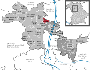
| Location of the Hemhofen community in the Erlangen-Höchstadt district | ||
  |
||


Hemhofen is a municipality and a village in the district of Erlangen-Höchstadt in Central Franconia .
geography
location
The community is about eleven kilometers northwest of Erlangen. It is surrounded by forests such as the Markwald and Weiherplatten.
Community structure

There are 2 districts :
- Hemhofen
- Twitching
Both districts now form a closed settlement.
Neighboring communities
The neighboring communities are Adelsdorf , Heroldsbach and Röttenbach .
history
Until the church is planted
The place was first mentioned in 1348 as "Hemhouen". The defining word of the place name is the personal name Hemo . A person of this name can be assumed to be the founder of the settlement. The settlement was probably built around the year 1000. According to the Evangelical Parish Book , a general description of the entire church system in the Evangelical-Lutheran parish of Hemhofen prepared by Pastor Friedrich Konstantin Kraussold, there is the note "Hemhofen is mentioned as early as 1062". According to legend, there used to be a sheep farm here. The manor took all kinds of people into service. This is how the village of Hammelhof came into being, and by contraction of the first syllables, Hemhofen. Although there are other interpretations of the place name to choose from, such as B. Hemhofen von Allweyer von Heimenhofen (family name), from Hof des Hemo or Hemmo , from Hof der Hemma and from Heimhof (house-home), the inhabitants still hold on to this legend today. Pastor Kraußold writes on the subject of the interpretation of the place name: “This view (Hemhofen von Hammelhof) is also reached by Bundschuh, who writes about Hemhofen in the Geographical Lexicon for Franconia 1800, Volume 2, Column 567: 'The place only existed before from some farms and a sheep farm '".
Hemhofen was a Protestant parish village for a long time, although the Reformation of the place came from the neighboring municipality of Röttenbach . In Röttenbach Castle, which was destroyed in the Peasants' War in 1525, the Truchsess von and zu Pommersfelden are said to have moved into an apartment since 1362 . These Truchsesse (court officials) accepted the Protestant faith in the 16th century and so their subjects in Hemhofen and Röttenbach also became Protestant . A counter-reformation by the Bamberg prince-bishop in 1628 was only successful in Röttenbach, Hemhofen remained Protestant.
In 1650, Hemhofen passed into his possession as a wedding gift from Truchseß von Pommersfelden to his daughter when she married Philipp Graf zu Pappenheim . After the count's death and remarriage, Hemhofen first came into the possession of Baron von Töstelberg in 1660. This began in 1715 with the construction of Hemhofen Castle, which he sold on July 11, 1722, together with the lands belonging to it, to the Winkler von Mohrenfels family . Wolfgang Christoph Winkler von Mohrenfels (1659–1729) was raised to the nobility by Emperor Joseph I in 1709 . He had made considerable wealth through energy and knowledge.
He turned the property acquired from Baron von Jöbstel (s) berg into a family affidavit , whose certificate dates from 1723. This document was confirmed by the Imperial Chancellery in Vienna in 1731 . Wolfgang Christoph von Mohrenfels finished the construction of the castle, but it was only under his son Georg Christoph (1709–1748) that the castle and its outbuildings grew to their considerable size and beauty. For a long time, Hemhofen Castle also served the Protestant community as a place of worship , because the barons Winkler von Mohrenfels employed castle preachers who were also private tutors of the noble family immediately after taking over the castle.
Towards the end of the 18th century there were 77 properties in Hemhofen (1 castle, 1 official house, 1 castle preacher's house, 1 official servant house, 1 shepherd's house, 1 brewery with 2 rock cellars, 1 mill, 15 estates, 10 drip estates, 31 residential houses, 11 drip houses , 1 Fall hut, 1 brick hut). The high court exercised the Winklerische rule Hemofen to a limited extent. If necessary, it had to be delivered to the Bamberg center forchheim . The rulership of Hemhofen held the village and community rulership as well as the land rulership over all properties.
In the Prussian-Bavarian mainland comparison in 1803, jurisdiction over the Bamberg knight's fiefdom Hemhofen der Winkler von Mohrenfels was assigned to the Prussian principality of Bayreuth, with which it fell to France in the Peace of Tilsit in 1807 and was ceded to Bavaria in 1810.
As part of the community edict , the place was assigned to the Röttenbach tax district formed in 1811 . With the second community edict (1818) the tax district and the rural community Hemhofen were formed, to which Zeckern belonged. This was subordinate to the regional court Herzogenaurach in administration and jurisdiction and in the financial administration to the Rentamt Erlangen . In the voluntary jurisdiction and the local police, the entire place was subordinate to the Hemhofen Patrimonial Court (until 1848). On October 1, 1847, the financial management was taken over by the Rentamt Herzogenaurach . From 1862 Hemhofen was administered by the district office of Höchstadt an der Aisch (renamed the district of Höchstadt an der Aisch in 1938 ) and continued to be administered by the Rent Office Herzogenaurach (1920–1929: Finanzamt Herzogenaurach , from 1929 Finanzamt Erlangen ). The jurisdiction remained with the district court of Herzogenaurach until 1879, 1880–1959 district court of Herzogenaurach , from 1959 district court of Erlangen . The community originally had an area of 4.804 km².
20th and 21st centuries
After the Second World War , displaced persons and the elderly found a place to stay in the castle. The building, which was largely renovated a few years ago, is now used for festivities such as weddings, birthday parties, or trade fairs such as Gartenlust and the Rose Fair.
In October 1984 Hemhofen was named the most beautiful place in the Erlangen-Höchstadt district in the district competition Our village should be more beautiful .
In 2005 Hemhofen and Zeckern celebrated their 650th birthday together (1355–2005).
Incorporations
On July 1, 1971, the previously independent municipality of Zeckern was incorporated.
Population development
Hemhofen community
| year | 1987 | 2008 | 2009 | 2010 | 2011 | 2012 | 2013 | 2014 | 2015 | 2016 | 2017 |
|---|---|---|---|---|---|---|---|---|---|---|---|
| Residents | 4278 | 5127 | 5122 | 5113 | 5193 | 5171 | 5191 | 5244 | 5367 | 5295 | 5298 |
| Houses | 1094 | 1430 | 1457 | 1471 | 1483 | ||||||
| source |
Hemhofen municipality (= Hemhofen municipality until 1971)
| year | 1818 | 1840 | 1852 | 1855 | 1861 | 1867 | 1871 | 1875 | 1880 | 1885 | 1890 | 1895 | 1900 | 1905 | 1910 | 1919 | 1925 | 1933 | 1939 | 1946 | 1950 | 1952 | 1961 | 1970 | 1987 |
|---|---|---|---|---|---|---|---|---|---|---|---|---|---|---|---|---|---|---|---|---|---|---|---|---|---|
| Residents | 538 | 634 | 636 | 675 | 642 | 643 | 623 | 591 | 598 | 601 | 593 | 606 | 572 | 554 | 533 | 617 | 639 | 666 | 660 | 1036 | 1048 | 1037 | 1151 | 1401 | 2770 |
| Houses | 84 | 112 | 115 | 112 | 121 | 131 | 185 | 717 | |||||||||||||||||
| source |
Denomination statistics
According to the 2011 census , 31.9% of the population in 2011 were Protestant , 45.0% were mostly Roman Catholic and 23.1% were non-denominational , belonged to another religious community or did not provide any information. Currently (as of December 31, 2019) of the 5,577 inhabitants, 1,481 (26.6%) are Protestant, 2,163 (38.8%) Roman Catholic and 1,933 (34.7%) are non-denominational or belong to another religious community. The number of Protestants and Catholics has therefore decreased in the observed period, but the majority of the inhabitants are still Catholic.
politics
Municipal council
The Hemhöfner municipal council has 20 members plus the first mayor.
Election results
| Parties / voter communities |
% 2020 |
Seats 2020 |
% 2014 |
Seats 2014 |
% 2008 |
Seats 2008 |
% 2002 |
Seats 2002 |
|
| CSU | Christian-Social Union in Bavaria | 37.6 | 7th | 38.1 | 8th | 31.7 | 6th | 30.9 | 6th |
| SPD | SPD Bavaria | 13.5 | 3 | 23.1 | 5 | 27.6 | 6th | 34.1 | 7th |
| FW | Free voters Bavaria | 21.8 | 4th | 16.3 | 3 | 28.7 | 6th | 22.1 | 5 |
| Green | Alliance 90 / The Green Bavaria | 19.5 | 4th | 11.9 | 2 | - | - | - | - |
| AW | General electorate | 7.6 | 2 | 10.6 | 2 | 11.9 | 2 | 9.6 | 2 |
| total | 100.0 | 20th | 100.0 | 20th | 100.0 | 20th | 100.0 | 20th | |
| Voter turnout in% | 65.7 | 65.4 | 71.5 | 73.8 | |||||
badges and flags
|
|
Blazon : "In silver on a golden three-mountain an unclothed Moor , in the upper left corner in a red label a silver booze pen."
White and red municipal flag |
| Founding of the coat of arms: The local coat of arms, decided by the Hemhofen community fathers in 1977, reminds of the Barons Winkler von Mohrenfels with the Mohren in the middle , the spit, the so-called pig's feather , refers to the Lords of Stiebar , the Lords of the mid-17th century Zeckern, today's district of Hemhofen. |
Community partnerships
Hemhofen has had a parish partnership with the Romanian parish Obereidisch (Ideciu de Sus) since July 4th, 2009 .
Infrastructure
The community is a preferred residential area for commuters to Erlangen.
Architectural monuments

- Jewish cemetery: There is a Jewish cemetery in the Zeckern district . With 15,169 m² it is one of the largest and oldest cemeteries in Bavaria - a cultural monument . Documentations in 1970 and 1979 counted 1,522 graves with around 800 tombstones on them. It is estimated that around 6,000 Jews were buried in the cemetery.
traffic
Both districts are crossed by the state road St 2259 , which runs from the federal road 470 in the north to Erlangen. The district road ERH 35 runs west to Heppstädt .
In the 2000s, it was discussed to reactivate the RB 24 ( Hirtenbachtalbahn ) from Forchheim to Zeckern. It has been clear since 2006 that the railway line will no longer be in operation. The railway started dismantling the single-track line from Höchstadt / Aisch to Forchheim in 2008 and removed it completely by the turn of the year 2009. This means that until further notice, there will be no need to connect Hemhofen with the Erlangen city-surrounding railway, as was variously planned in the 1990s.
literature
- Ingomar Bog : Forchheim (= Historical Atlas of Bavaria, part of Franconia . I, 5). Komm. Für Bayerische Landesgeschichte, Munich 1955, DNB 450540367 , p. 59 ( digitized version ).
- Johann Kaspar Bundschuh : Hemhofen . In: Geographical Statistical-Topographical Lexicon of Franconia . tape 2 : El-H . Verlag der Stettinische Buchhandlung, Ulm 1800, DNB 790364298 , OCLC 833753081 , Sp. 567 ( digitized version ).
- Georg Daßler (Ed.): District of Höchstadt ad Aisch. Past and present . Verl. F. Authorities and Wirtschaft Hoeppner, Aßling-Munich 1970, DNB 457004320 , p. 76 .
- Hanns Hubert Hofmann : Höchstadt-Herzogenaurach (= Historical Atlas of Bavaria, part Franconia . I, 1). Commission for Bavarian State History, Munich 1951, DNB 452071143 , p. 143 ( digitized version ).
- Franz Krug (ed.): The district of Erlangen-Höchstadt . Publishing house for authorities a. Wirtschaft, Hof (Saale) 1979, ISBN 3-921603-00-5 , p. 108 .
- Wolf-Armin von Reitzenstein : Lexicon of Franconian place names. Origin and meaning . Upper Franconia, Middle Franconia, Lower Franconia. CH Beck, Munich 2009, ISBN 978-3-406-59131-0 , p. 99 .
- Pleikard Joseph Stumpf : Heinhofen . In: Bavaria: a geographical-statistical-historical handbook of the kingdom; for the Bavarian people . Second part. Munich 1853, p. 589 ( digitized version ).
Web links
- Local government
- Hemhofen: Official statistics of the LfStat
- Hemhofen in the Topographia Franconiae of the University of Würzburg , accessed on September 27, 2019.
Individual evidence
- ↑ "Data 2" sheet, Statistical Report A1200C 202041 Population of the municipalities, districts and administrative districts 1st quarter 2020 (population based on the 2011 census) ( help ).
- ↑ Municipal Council. Hemhofen community, accessed on August 15, 2020 .
- ^ Municipality of Hemhofen in the local database of the Bavarian State Library Online . Bayerische Staatsbibliothek, accessed on September 27, 2019.
- ↑ W.-A. v. Reitzenstein, p. 99.
- ↑ I. Bog, p. 59.
- ^ Address and statistical manual for the Rezatkreis in the Kingdom of Baiern . Buchdruckerei Chancellery, Ansbach 1820, p. 49 ( digitized version ).
- ^ HH Hofmann, p. 143.
- ↑ a b Bavarian State Statistical Office (ed.): Official city directory for Bavaria, territorial status on October 1, 1964 with statistical information from the 1961 census . Issue 260 of the articles on Bavaria's statistics. Munich 1964, DNB 453660959 , Section II, Sp. 679 ( digitized version ).
- ^ Wilhelm Volkert (ed.): Handbook of Bavarian offices, communities and courts 1799–1980 . CH Beck, Munich 1983, ISBN 3-406-09669-7 , p. 484 .
- ↑ a b Only inhabited houses are given. In 1818 these were called fire places, from 1871 to 2017 as residential buildings.
- ↑ a b Bavarian State Office for Statistics and Data Processing (Ed.): Official local directory for Bavaria, territorial status: May 25, 1987 . Issue 450 of the articles on Bavaria's statistics. Munich November 1991, DNB 94240937X , p. 334 ( digitized version ).
- ↑ a b c d e f g h i j LfStat : Hemhofen: Official statistics. In: statistik.bayern.de. Pp. 6 and 12 , accessed on October 26, 2019 .
- ↑ Alphabetical index of all the localities contained in the Rezatkkreis according to its constitution by the newest organization: with indication of a. the tax districts, b. Judicial Districts, c. Rent offices in which they are located, then several other statistical notes . Ansbach 1818, p. 38 ( digitized version ).
- ↑ a b c d e f g h i j k l m n o Bavarian State Statistical Office (Hrsg.): Historical municipality register: The population of the municipalities of Bavaria from 1840 to 1952 (= contributions to Statistics Bavaria . Issue 192). Munich 1954, DNB 451478568 , p. 146 , urn : nbn: de: bvb: 12-bsb00066439-3 ( digitized version ).
- ^ Joseph Heyberger, Chr. Schmitt, v. Wachter: Topographical-statistical manual of the Kingdom of Bavaria with an alphabetical local dictionary . In: K. Bayer. Statistical Bureau (Ed.): Bavaria. Regional and folklore of the Kingdom of Bavaria . tape 5 . Literary and artistic establishment of the JG Cotta'schen Buchhandlung, Munich 1867, Sp. 876 , urn : nbn: de: bvb: 12-bsb10374496-4 ( digitized version ).
- ↑ Kgl. Statistical Bureau (ed.): Complete list of localities of the Kingdom of Bavaria. According to districts, administrative districts, court districts and municipalities, including parish, school and post office affiliation ... with an alphabetical general register containing the population according to the results of the census of December 1, 1875 . Adolf Ackermann, Munich 1877, 2nd section (population figures from 1871, cattle figures from 1873), Sp. 1049 , urn : nbn: de: bvb: 12-bsb00052489-4 ( digitized version ).
- ↑ K. Bayer. Statistical Bureau (Ed.): Localities directory of the Kingdom of Bavaria. According to government districts, administrative districts, ... then with an alphabetical register of locations, including the property and the responsible administrative district for each location. LIV. Issue of the contributions to the statistics of the Kingdom of Bavaria. Munich 1888, Section III, Sp. 994 ( digitized version ).
- ↑ K. Bayer. Statistical Bureau (Ed.): Directory of localities of the Kingdom of Bavaria, with alphabetical register of places . LXV. Issue of the contributions to the statistics of the Kingdom of Bavaria. Munich 1904, Section II, Sp. 1043 ( digitized version ).
- ↑ Bavarian State Statistical Office (ed.): Localities directory for the Free State of Bavaria according to the census of June 16, 1925 and the territorial status of January 1, 1928 . Issue 109 of the articles on Bavaria's statistics. Munich 1928, Section II, Sp. 1077 ( digitized version ).
- ↑ Bavarian State Statistical Office (ed.): Official place directory for Bavaria - edited on the basis of the census of September 13, 1950 . Issue 169 of the articles on Bavaria's statistics. Munich 1952, DNB 453660975 , Section II, Sp. 923 ( digitized version ).
- ^ Bavarian State Statistical Office (ed.): Official place directory for Bavaria . Issue 335 of the articles on Bavaria's statistics. Munich 1973, DNB 740801384 , p. 173 ( digitized version ).
- ↑ Hemhofen Religion , 2011 census
- ↑ Hemhofen community portrait facts and figures , accessed on April 1, 2020
- ↑ [1]
- ↑ Result of the 2014 local elections
- ^ Result of the 2008 local elections
- ^ Result of the local elections in 2002
- ^ Entry on the coat of arms of Hemhofen in the database of the House of Bavarian History
- ↑ Hemhofen. In: Kommunalflaggen.eu. Retrieved July 4, 2020 .
- ↑ Hemhofen community - partner community. Retrieved on May 26, 2018 (German).

Adelsdorf | Aurachtal | Baiersdorf | Bubenreuth | Buckenhof | Eckental | Gremsdorf | Großenseebach | Hemhofen | Heroldsberg | Herzogenaurach | Hessdorf | Höchstadt an der Aisch | Kalchreuth | Lonnerstadt | Marloffstein | Möhrendorf | Mulhouse | Oberreichenbach | Röttenbach | Savings Village | Uttenreuth | Vestenbergsgreuth | Wachenroth | Weisendorf
Unregulated areas in the district of Erlangen-Höchstadt
Birkach |
Buckenhofer Forest |
Dormitzer Forest |
Erlenstegen Forest |
Forest Tennenlohe |
Geschaidt |
Kalchreuther Forest |
Kraftshofer Forest |
Mark |
Neunhofer Forest