
Vestenbergsgreuth
| coat of arms | Germany map | |
|---|---|---|

|
Coordinates: 49 ° 41 ′ N , 10 ° 39 ′ E |
|
| Basic data | ||
| State : | Bavaria | |
| Administrative region : | Middle Franconia | |
| County : | Erlangen-Höchstadt | |
| Management Community : | Höchstadt an der Aisch | |
| Height : | 305 m above sea level NHN | |
| Area : | 31.85 km 2 | |
| Residents: | 1558 (Dec. 31, 2019) | |
| Population density : | 49 inhabitants per km 2 | |
| Postal code : | 91487 | |
| Area code : | 09163 | |
| License plate : | ERH, HÖS | |
| Community key : | 09 5 72 159 | |
| LOCODE : | DE VES | |
| Market structure: | 14 parts of the community | |
Market administration address : |
Dutendorfer Strasse 22 91487 Vestenbergsgreuth |
|
| Website : | ||
| Mayor : | Helmut Lottes ( CSU ) | |
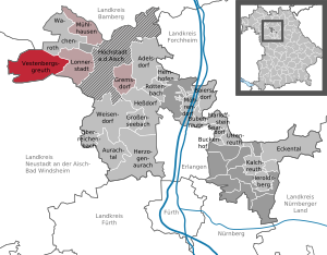
| Location of the Vestenbergsgreuth market in the Erlangen-Höchstadt district | ||
  |
||

Vestenbergsgreuth is a market in the Middle Franconian district of Erlangen-Höchstadt and a member of the administrative community of Höchstadt an der Aisch .
geography
Geographical location
Vestenbergsgreuth is located in the industrial region of Middle Franconia. At one edge of the forest 600 meters west of the district ox leg is a point as the center franc (at 49.7173 ° N , 10.6349 ° O hereinafter). It is a place that is on average the shortest distance from all of Franconia's borders.
Community structure
The market has 14 districts :
|
There are the districts of Dutendorf, Frickenhöchstadt, Frimmersdorf, Kleinweisach and Vestenbergsgreuth.
Neighboring communities
Neighboring municipalities are (starting in the north in a clockwise direction):
Schlüsselfeld , Wachenroth , Lonnerstadt , Uehlfeld , Münchsteinach , Taschendorf market , Burghaslach
history
The place was first mentioned in 1217 as "Rvte". The place name is based on the Middle High German word riute (= clearing) and refers to land reclamation through clearing. Only in 1469/70 is the form "Vestenberger's regrets" attested. The term serves to better distinguish the numerous places called Reuth and refers to the wealthy gentlemen von Vestenberg there .
The manor Vestenbergsgreuth and the surrounding area were owned by the Lords of Vestenberg until 1687 . When the place came to Christoph Siegmund von Holzschuher in 1756 , he experienced an economic and cultural boom. The Holzschuher von Harrlach family held high and low jurisdiction. The families belonged to the knight canton of Steigerwald of the Franconian knight circle .
With the Rhine Federation Act in 1806, the place came to the new Kingdom of Bavaria . As part of the municipal edict in 1808, the place was initially assigned to the Breitenlohe tax district , and finally to the Dutendorf tax district in 1810 . In 1818 the rural community Vestenbergsgreuth was formed, to which Hermersdorf belonged. In administration and jurisdiction it was subordinate to the regional court of Höchstadt and in financial administration to the Rent Office of Höchstadt . In the voluntary jurisdiction and the local police, the whole place was under the patrimonial court of Vestenbergsgreuth. From 1862 Vestenbergsgreuth was administered by the district office of Höchstadt an der Aisch (renamed the district of Höchstadt an der Aisch in 1938 ) and continued to be administered by the rent office of Höchstadt (1920–1929: tax office Höchstadt , from 1929: tax office Forchheim ). The jurisdiction remained with the district court of Höchstadt until 1879, 1880–1959 district court of Höchstadt , from 1959 district court of Forchheim . In 1961 the municipality had an area of 3.310 km².
Incorporations
On January 1, 1974 Frimmersdorf was incorporated. On May 1, 1978, the independent community Weisachgrund was added, which was created on January 1, 1972 through the merger of the former communities Dutendorf, Frickenhöchstadt and Kleinweisach.
Population development
Vestenbergsgreuth community
| year | 1827 | 1840 | 1852 | 1861 | 1867 | 1871 | 1875 | 1880 | 1885 | 1890 | 1895 | 1900 | 1905 | 1910 | 1919 | 1925 | 1933 | 1939 | 1946 | 1950 | 1961 | 1970 | 1987 | 2008 | 2013 | 2017 |
|---|---|---|---|---|---|---|---|---|---|---|---|---|---|---|---|---|---|---|---|---|---|---|---|---|---|---|
| Residents | 378 | 477 | 398 | 414 | 427 | 441 | 417 | 429 | 408 | 373 | 374 | 385 | 412 | 384 | 368 | 338 | 357 | 356 | 563 | 472 | 346 | 352 | 1132 | 1574 | 1500 | 1515 |
| Houses | 77 | 75 | 78 | 79 | 74 | 80 | 323 | 514 | ||||||||||||||||||
| source |
Part of the municipality Vestenbergsgreuth
| year | 1827 | 1861 | 1871 | 1885 | 1900 | 1925 | 1950 | 1961 | 1970 | 1987 |
|---|---|---|---|---|---|---|---|---|---|---|
| Residents | 325 | 340 | 364 | 345 | 307 | 275 | 398 | 289 | 293 | 298 |
| Houses | 63 | 64 | 58 | 62 | 66 | 95 | ||||
| source |
politics
mayor
The first mayor has been Helmut Lottes ( CSU ) since 2010 .
Market council
The past local elections resulted in the following allocation of seats in the market town council:
| CSU / Independent Citizen | SPD | Frimmersdorf Citizens' Block | WG Oberer Weisachgrund | Free voters | Independent citizens | total | |
| 2020 | 3 | 1 | 4th | 4th | n / A. | n / A. | 12 seats |
| 2014 | 5 | 1 | 4th | 2 | n / A. | n / A. | 12 seats |
| 2008 | 3 * | 1 | 3 | 2 | n / A. | 3 | 12 seats |
| 2002 | n / A. * | 1 | 3 | 2 | 6th | n / A. | 12 seats |
coat of arms
The municipality of Vestenbergsgreuth has had a coat of arms since 1970.
|
|
Blazon : “ Divided by green and gold; above a silver bar , below a red lined black wooden shoe . " |
| Foundation of the coat of arms: The manor Vestenbergsgreuth and the surrounding area were owned by the Lords of Vestenberg until 1687 . The family coat of arms with the silver bar in the green field reminds of this. In 1756 the place came to the Nuremberg patricians Holzschuher . The wooden shoe that speaks for the family name comes from the family coat of arms. |
Partner municipality
Economy and Infrastructure
Economy including agriculture and forestry
In 1998, according to official statistics, there were 503 people in the manufacturing sector and no employees in the trade and transport sector who were subject to social security contributions at the place of work. In other economic sectors 270 people were employed at the place of work subject to social security contributions. There were a total of 580 employees at the place of residence subject to social security contributions. There was one company in the manufacturing sector (a larger pharmaceutical and tea manufacturer) and two companies in the main construction sector. In addition, there were 68 farms in 1999 with an agricultural area of 1377 hectares, of which 1095 hectares were arable land and 268 hectares were permanent green space.
The first GMO-free soybean field in Franconia has been located there since May 2010, with an area of 25 hectares and a yield of around three tons, which is intended to serve the regional chicken farm for the production of animal feed.
Martin Bauer Group
The Martin Bauer Group is a holding company made up of more than 20 globally active companies with around 3000 employees in the field of herbal and fruit teas or extracts, herbal powders and raw materials as well as food supplements for the tea, beverage and phytopharmaceutical industries .
traffic
The market is located south of the highway A3 . The district road ERH 21 runs southwest to Kienfeld or west to the district road ERH 20 , approx. 0.5 km south of Hermersdorf . The district road ERH 19 / NEA 12 runs south to Schornweisach or north to Dutendorf . A community road runs northeast to Hermersdorf to ERH 20.
Recreational facilities
- Leisure facility with summer toboggan run , snow tubing track and mini golf course
- Youth camp of the district youth ring with youth hostel (33 beds) and two youth tent spaces
education
There are the following facilities:
- Day care center: 95 places with 67 children, 22 of them under 3 years of age, 26 from 3 to under 6 years and 19 from 6 years (as of 2015)
Sports
The football department of the football club TSV Vestenbergsgreuth , which at the time played in the Regionalliga Süd, joined SpVgg Fürth in 1996. After the merger, SpVgg Fürth started as SpVgg Greuther Fürth for the first time in the 1996/97 season .
The club became known nationwide in 1994 when it reached the third round of the DFB Cup. On the way there, TSV Vestenbergsgreuth defeated FC Bayern Munich 1-0 in the first round, with Roland Stein's goal scorer.
Attractions

- Vestenbergsgreuth Castle , mansard roof, sandstone cuboid, inscribed "1785"
- Jewish school in Vestenbergsgreuth with prayer room (synagogue), religious school and ritual bath of the community
- Former school building in Vestenbergsgreuth, plastered hipped roof building with half-timbered tower, in the core 1776; equipped with a tower clock and three bells
- Evangelical-Lutheran branch church in Pretzdorf, choir tower church, second half of the 15th century, nave in the first half of the 18th century partially redesigned in Baroque style; with equipment
- Evangelical-Lutheran parish church in Kleinweisach, choir tower church, second half of the 15th century, the tower raised in 1704, the nave redesigned in 1725 and 1763; with equipment
- Former brewery in Dutendorf, solid ground floor, timber-framed upper floor, core around 1630, renovations in the 18th and mid-19th centuries, partially modernized
literature
- Johann Kaspar Bundschuh : Vestenbergsgreuth . In: Geographical Statistical-Topographical Lexicon of Franconia . tape 6 : V-Z . Verlag der Stettinische Buchhandlung, Ulm 1804, DNB 790364328 , OCLC 833753116 , Sp. 16-18 ( digitized version ).
- Georg Daßler (Ed.): District of Höchstadt ad Aisch. Past and present . Verl. F. Authorities and Wirtschaft Hoeppner, Aßling-Munich 1970, DNB 457004320 , p. 131-132 .
- Hanns Hubert Hofmann : Höchstadt-Herzogenaurach (= Historical Atlas of Bavaria, part Franconia . I, 1). Commission for Bavarian State History, Munich 1951, DNB 452071143 , p. 136 ( digitized version ).
- Franz Krug (ed.): The district of Erlangen-Höchstadt . Publishing house for authorities a. Wirtschaft, Hof (Saale) 1979, ISBN 3-921603-00-5 , p. 170-175 .
- Wolf-Armin von Reitzenstein : Lexicon of Franconian place names. Origin and meaning . Upper Franconia, Middle Franconia, Lower Franconia. CH Beck, Munich 2009, ISBN 978-3-406-59131-0 , p. 229-230 .
Web links
- Vestenbergsgreuth website
- Vestenbergsgreuth in the Topographia Franconiae of the University of Würzburg , accessed on September 26, 2019.
- Vestenbergsgreuth: Official statistics of the LfStat
Individual evidence
- ↑ "Data 2" sheet, Statistical Report A1200C 202041 Population of the municipalities, districts and administrative districts 1st quarter 2020 (population based on the 2011 census) ( help ).
- ↑ Horst Auer: The navel of Franconia . In Nürnberger Nachrichten , June 5, 2008, last accessed on April 8, 2014
- ^ Community Vestenbergsgreuth in the local database of the Bayerische Landesbibliothek Online . Bayerische Staatsbibliothek, accessed on September 26, 2019.
- ↑ In medieval Oberwinterbach the parish Gutenstetten , the early mass Reinhardshofen and Konrad von Pahres (feudal bearer of Oberhöchstädt and Frauenaurach monastery) owned. In 1660 the place was deserted. See Max Döllner : Development history of the city of Neustadt an der Aisch until 1933. Ph. C. W. Schmidt, Neustadt a. d. Aisch 1950, OCLC 42823280 ; New edition to mark the 150th anniversary of the Ph. C. W. Schmidt publishing house, Neustadt an der Aisch 1828–1978. Ibid 1978, ISBN 3-87707-013-2 , p. 141.
- ↑ W.-A. v. Reitzenstein, p. 229f.
- ↑ HH Hofmann, p. 136.
- ↑ a b c Bavarian State Statistical Office (ed.): Official city directory for Bavaria, territorial status on October 1, 1964 with statistical information from the 1961 census . Issue 260 of the articles on Bavaria's statistics. Munich 1964, DNB 453660959 , Section II, Sp. 682 ( digitized version ).
- ^ Federal Statistical Office (ed.): Historical municipality directory for the Federal Republic of Germany. Name, border and key number changes in municipalities, counties and administrative districts from May 27, 1970 to December 31, 1982 . W. Kohlhammer, Stuttgart / Mainz 1983, ISBN 3-17-003263-1 , p. 711 .
- ^ Wilhelm Volkert (ed.): Handbook of Bavarian offices, communities and courts 1799–1980 . CH Beck, Munich 1983, ISBN 3-406-09669-7 , p. 484 .
- ↑ a b Only inhabited houses are given, designated as residential buildings from 1871 to 2017 .
- ^ A b Karl Friedrich Hohn (Hrsg.): Geographical-statistical description of the Upper Main district . J. Dederich, Bamberg 1827, p. 134 ( digitized version ). For the municipality of Vestenbergsgreuth plus the residents of Hermersdorf (p. 131).
- ↑ a b c d e f g h i j k l m Bavarian State Statistical Office (Hrsg.): Historical municipality register: The population of the municipalities of Bavaria from 1840 to 1952 (= contributions to Statistics Bavaria . Issue 192). Munich 1954, DNB 451478568 , p. 146 , urn : nbn: de: bvb: 12-bsb00066439-3 ( digitized version ).
- ↑ a b Joseph Heyberger, Chr. Schmitt, v. Wachter: Topographical-statistical manual of the Kingdom of Bavaria with an alphabetical local dictionary . In: K. Bayer. Statistical Bureau (Ed.): Bavaria. Regional and folklore of the Kingdom of Bavaria . tape 5 . Literary and artistic establishment of the JG Cotta'schen Buchhandlung, Munich 1867, Sp. 875 , urn : nbn: de: bvb: 12-bsb10374496-4 ( digitized version ).
- ↑ a b Kgl. Statistical Bureau (ed.): Complete list of localities of the Kingdom of Bavaria. According to districts, administrative districts, court districts and municipalities, including parish, school and post office affiliation ... with an alphabetical general register containing the population according to the results of the census of December 1, 1875 . Adolf Ackermann, Munich 1877, 2nd section (population figures from 1871, cattle figures from 1873), Sp. 1048 , urn : nbn: de: bvb: 12-bsb00052489-4 ( digital copy ).
- ↑ a b K. Bayer. Statistical Bureau (Ed.): Localities directory of the Kingdom of Bavaria. According to government districts, administrative districts, ... then with an alphabetical register of locations, including the property and the responsible administrative district for each location. LIV. Issue of the contributions to the statistics of the Kingdom of Bavaria. Munich 1888, Section III, Sp. 992 ( digitized version ).
- ↑ a b K. Bayer. Statistical Bureau (Ed.): Directory of localities of the Kingdom of Bavaria, with alphabetical register of places . LXV. Issue of the contributions to the statistics of the Kingdom of Bavaria. Munich 1904, Section II, Sp. 1041-1042 ( digitized version ).
- ↑ a b Bavarian State Statistical Office (ed.): Localities directory for the Free State of Bavaria according to the census of June 16, 1925 and the territorial status of January 1, 1928 . Issue 109 of the articles on Bavaria's statistics. Munich 1928, Section II, Sp. 1075 ( digitized version ).
- ↑ a b Bavarian State Statistical Office (ed.): Official place directory for Bavaria - edited on the basis of the census of September 13, 1950 . Issue 169 of the articles on Bavaria's statistics. Munich 1952, DNB 453660975 , Section II, Sp. 926 ( digitized version ).
- ↑ a b Bavarian State Statistical Office (Hrsg.): Official local directory for Bavaria . Issue 335 of the articles on Bavaria's statistics. Munich 1973, DNB 740801384 , p. 174 ( digitized version ).
- ↑ a b Bavarian State Office for Statistics and Data Processing (Ed.): Official local directory for Bavaria, territorial status: May 25, 1987 . Issue 450 of the articles on Bavaria's statistics. Munich November 1991, DNB 94240937X , p. 336 ( digitized version ).
- ↑ a b c LfStat : Vestenbergsgreuth: Official statistics. In: statistik.bayern.de. Pp. 6 and 12 , accessed on October 9, 2019 .
- ^ Entry on the coat of arms of Vestenbergsgreuth in the database of the House of Bavarian History
- ↑ Domestic GMO-free soy for Franconian eggs (PDF; 150 kB) July 21, 2010

Adelsdorf | Aurachtal | Baiersdorf | Bubenreuth | Buckenhof | Eckental | Gremsdorf | Großenseebach | Hemhofen | Heroldsberg | Herzogenaurach | Hessdorf | Höchstadt an der Aisch | Kalchreuth | Lonnerstadt | Marloffstein | Möhrendorf | Mulhouse | Oberreichenbach | Röttenbach | Savings Village | Uttenreuth | Vestenbergsgreuth | Wachenroth | Weisendorf
Unregulated areas in the district of Erlangen-Höchstadt
Birkach |
Buckenhofer Forest |
Dormitzer Forest |
Erlenstegen Forest |
Forest Tennenlohe |
Geschaidt |
Kalchreuther Forest |
Kraftshofer Forest |
Mark |
Neunhofer Forest