
Taschendorf market
| coat of arms | Germany map | |
|---|---|---|

|
Coordinates: 49 ° 42 ' N , 10 ° 33' E |
|
| Basic data | ||
| State : | Bavaria | |
| Administrative region : | Middle Franconia | |
| County : | Neustadt an der Aisch-Bad Windsheim | |
| Management Community : | Scheinfeld | |
| Height : | 342 m above sea level NHN | |
| Area : | 27.66 km 2 | |
| Residents: | 989 (Dec. 31, 2019) | |
| Population density : | 36 inhabitants per km 2 | |
| Postal code : | 91480 | |
| Area code : | 09552 | |
| License plate : | NEA, SEF, UFF | |
| Community key : | 09 5 75 147 | |
| LOCODE : | DE MKF | |
| Market structure: | 11 parts of the community | |
Market administration address : |
Erlanger Str. 15 91480 Markt Taschendorf |
|
| Website : | ||
| Mayor : | Johannes Oeder ( Citizens' Block ) | |
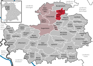
| Location of the Markt Taschendorf market in the Neustadt an der Aisch-Bad Windsheim district | ||
  |
||


Markt Taschendorf is a market in the district of Neustadt an der Aisch-Bad Windsheim in Middle Franconia and a member of the Scheinfeld administrative association .
geography
Geographical location
The community, surrounded by fields and meadows, partly also by forest, is located in a hilly landscape in the southern part of the Steigerwald and is traversed by the Kleine Weisach . The Steinach coming from the neighboring Kornhöfstadt flows through the districts of Frankfurt, Lachheim and Obersteinbach. The highest point in the municipality is the Hohe Föhre at 434 m.
Neighboring communities
Neighboring communities are (starting from the north clockwise): Burghaslach , Vestenbergsgreuth , Münchsteinach , Baudenbach and Scheinfeld .
Community structure
The municipality has eleven officially named municipal parts (the type of settlement is given in brackets ):
|
history
From the time from 850 to 550 BC There are finds of barrows in the area. Taschendorf was founded around the 9th century AD.
In 1285 the place was first mentioned as "Toschendorff", in 1311 with the addition "inferior" (the lower one) and in 1340 with the addition "Nidern" to better distinguish it from the (upper) Taschendorf to the west. In 1500 Taschendorf received market rights , and in 1599 it was first called "Marck Doschendorff". The place name is a Slavic-German mixed name : The basic word is the Middle High German village , the defining word is probably the Slavic personal name Toš .
Signs of eleven submerged villages and settlements were found in the immediate vicinity. Their decay was probably caused by climate deterioration and famine in the 15th century and the Thirty Years War .
To the north of the Kleine Weisach, the Fraisch held the Cent Burghaslach of the county of Castell and to the south of the Kleine Weisach the office of Scheinfeld of the prince-duchy of Schwarzenberg . The landlord was the manor Obersteinbach .
In 1806 Taschendorf became part of the new Kingdom of Bavaria . As part of the municipal edict, the tax district Taschendorf was formed in 1808 , to which Butzenmühle, Obertaschendorf and Hombeer belonged. The rural community of Taschendorf, founded in 1813, was congruent with the tax district. Until 1810 it was under the administration and jurisdiction of the Scheinfeld district court and the tax office of Iphofen . The voluntary jurisdiction and the local police exercised the Obersteinbach Patrimonial Court until 1848 , the Schwarzenberg Lordship Court was responsible for one property . In 1810 the places came to the district court of Höchstadt and the rent office of Höchstadt . On October 31, 1819, the community was handed over to the Neustadt an der Aisch Regional Court and the Neustadt an der Aisch Rent Office . At the same time Hombeer was reassigned to Altershausen . On February 12, 1827, the community was handed over to the Markt Bibart district court and the Iphofen rent office.
In the first half of the 19th century, Gossenberger, the tenant of the Obersteinbach manor, introduced animals of the yellow Heilbronn breed and others from Baden into his cattle breeding, which he crossed with the local landrace. The resulting Scheinfelder Schlag 'became known nationwide and contributed to the boom in the Neustadt cattle trade that developed around 1834.
In 1862 Taschendorf was administratively responsible for the Scheinfeld district office (renamed the Scheinfeld district in 1938 ) and the Markt Bibart rent office from 1856 (1920–1929: Markt Bibart tax office, Neustadt an der Aisch tax office from 1929 ). The jurisdiction remained with the district court of Markt Bibart until 1879, from 1880 the district court of Scheinfeld . In 1885 the municipality had an area of 10.358 km², which decreased from 1900 onwards by 8.787 km².
20th century
On February 2, 1963, the community name was officially changed from Taschendorf to Markt Taschendorf.
Land consolidation was carried out from 1973 to 1984, and village renewal was completed in 1987.
Incorporations
On January 1, 1972, the previously independent communities of Frankfurt (with Klösmühle ) and Obersteinbach (with Lachheim , Lerchenhöchstadt and Wilhelminenberg ) as well as parts of the dissolved communities of Altershausen (only Hombeer ) and Kornhöfstadt (only Birkach ) were incorporated.
Before the regional reform in 1972 , Hombeer belonged to the former district of Neustadt an der Aisch , and all other parts of the community belonged to the former Scheinfeld district .
Population development
In the period from 1988 to 2018, the population increased from 943 to 985 by 42 inhabitants or 4.5%.
Municipality of Markt Taschendorf
| year | 1824 | 1840 | 1852 | 1861 | 1867 | 1871 | 1875 | 1880 | 1885 | 1890 | 1895 | 1900 | 1905 | 1910 | 1919 | 1925 | 1933 | 1939 | 1946 | 1950 | 1961 | 1970 | 1987 | 2007 | 2012 | 2016 |
|---|---|---|---|---|---|---|---|---|---|---|---|---|---|---|---|---|---|---|---|---|---|---|---|---|---|---|
| Residents | 609 | 459 | 481 | 457 | 484 | 487 | 485 | 483 | 485 | 430 | 418 | 418 | 422 | 439 | 406 | 401 | 367 | 353 | 517 | 493 | 375 | 432 | 960 | 1029 | 1004 | 1003 |
| Houses | 91 | 75 | 77 | 79 | 80 | 74 | 76 | 79 | 260 | 354 | ||||||||||||||||
| source |
Part of the municipality of Markt Taschendorf
| year | 1824 | 1840 | 1861 | 1871 | 1885 | 1900 | 1925 | 1950 | 1961 | 1970 | 1987 |
|---|---|---|---|---|---|---|---|---|---|---|---|
| Residents | 376 | 344 | 351 | 361 | 367 | 321 | 311 | 366 | 267 | 299 | 312 |
| Houses | 50 | 57 | 60 | 61 | 58 | 58 | 60 | 98 | |||
| source |
politics
Market council
The 2008 local elections led to the following distribution of seats in the municipal council (compared to the 2002 election):
- CSU / Free Citizens 4 seats (−2)
- Citizen block 5 seats (+1)
- Free community of voters 3 seats (+1)
coat of arms
The municipality of Markt Taschendorf has had a coat of arms since 1975.
|
|
Blazon : “ Divided ; above in gold a green scales; divided obliquely from below, above and below black geschacht of silver, and red. " |
| Foundation of the coat of arms: The scales indicate the markets, which were documented as early as the 17th century and which were of great importance for the economic life in the municipality. In the lower half is the coat of arms of the Lords of Lentersheim , who can be proven as lords of the castle in the Obersteinbach part of the municipality. |
Architectural monuments
Economy and Infrastructure
education
Markt Taschendorf is a member of the Scheinfeld School Association.
structure
The community is agriculturally oriented; In the second half of the 20th century, the character of the area changed towards a residential community due to new settlement areas. Small and medium-sized trades and tourism also play a role.
traffic
State road 2417 runs through Markt Taschendorf and leads to Frankfurt or Hombeer . District road NEA 9 leads to Obertaschendorf , NEA 7 to Kirchrimbach .
Sons and daughters of the church
- Johann Samuel Wiesner (1723–1780), Protestant theologian, educator and orientalist
- Erich Häußer (1930–1999), lawyer
- Hans Pfeifer (1934–2019), clarinetist and professor for clarinet
literature
- Johann Kaspar Bundschuh : market pocket village . In: Geographical Statistical-Topographical Lexicon of Franconia . tape 6 : V-Z . Verlag der Stettinische Buchhandlung, Ulm 1804, DNB 790364328 , OCLC 833753116 , Sp. 838 ( digitized version ).
- Hanns Hubert Hofmann : Höchstadt-Herzogenaurach (= Historical Atlas of Bavaria, part Franconia . I, 1). Commission for Bavarian State History, Munich 1951, DNB 452071143 , p. 138 ( digitized version ).
- Hanns Hubert Hofmann : Neustadt-Windsheim (= Historical Atlas of Bavaria, part of Franconia . I, 2). Commission for Bavarian State History, Munich 1953, DNB 452071216 , p. 195 ( digitized version ).
- Gerhard Hojer: District of Scheinfeld (= Bavarian art monuments . Volume 35 ). Deutscher Kunstverlag, Munich 1976, DNB 760102457 , p. 204-208 .
- Wolf Dieter Ortmann: District of Scheinfeld (= Historical Place Name Book of Bavaria, Middle Franconia . Volume 3 ). Commission for Bavarian State History, Munich 1967, DNB 457000929 , p. 197-198 .
- Wolf-Armin von Reitzenstein : Lexicon of Franconian place names. Origin and meaning . Upper Franconia, Middle Franconia, Lower Franconia. CH Beck, Munich 2009, ISBN 978-3-406-59131-0 , p. 144 .
- Peter Schneider : The Steigerwald as a whole . Stürtz, Würzburg 1958, DNB 454428790 , p. 321-322 .
- Pleikard Joseph Stumpf : Taschendorf . In: Bavaria: a geographical-statistical-historical handbook of the kingdom; for the Bavarian people . Second part. Munich 1853, p. 758 ( digitized version ).
Web links
- History of the market
- Markt Taschendorf: Official statistics of the LfStat
- Markt Taschendorf in the Topographia Franconiae of the University of Würzburg , accessed on September 19, 2019.
- Markt Taschendorf in the historical directory of the association for computer genealogy
Individual evidence
- ↑ "Data 2" sheet, Statistical Report A1200C 202041 Population of the municipalities, districts and administrative districts 1st quarter 2020 (population based on the 2011 census) ( help ).
- ^ Community of Markt Taschendorf in the local database of the Bavarian State Library Online . Bayerische Staatsbibliothek, accessed on September 19, 2019.
- ↑ W.-A. v. Reitzenstein, p. 144.
- ↑ a b c d H. H. Hofmann, p. 195.
- ^ Max Döllner : History of the development of the city of Neustadt an der Aisch up to 1933. Ph. C. W. Schmidt, Neustadt a. d. Aisch 1950, OCLC 42823280 ; New edition to mark the 150th anniversary of the Ph. C. W. Schmidt publishing house, Neustadt an der Aisch 1828–1978. Ibid 1978, ISBN 3-87707-013-2 , p. 443.
- ↑ a b c K. Bayer. Statistical Bureau (Ed.): Localities directory of the Kingdom of Bavaria. According to government districts, administrative districts, ... then with an alphabetical register of locations, including the property and the responsible administrative district for each location. LIV. Issue of the contributions to the statistics of the Kingdom of Bavaria. Munich 1888, Section III, Sp. 1184 ( digitized version ).
- ↑ a b c K. Bayer. Statistical Bureau (Ed.): Directory of localities of the Kingdom of Bavaria, with alphabetical register of places . LXV. Issue of the contributions to the statistics of the Kingdom of Bavaria. Munich 1904, Section II, Sp. 1256 ( digitized version ).
- ↑ a b Wilhelm Volkert (Ed.): Handbook of the Bavarian offices, communities and courts 1799–1980 . CH Beck, Munich 1983, ISBN 3-406-09669-7 , p. 565 .
- ↑ http://wiki-de.genealogy.net/Markt_Taschendorf
- ↑ a b Only inhabited houses are given. In 1824 these were designated as fireplaces , in 1840 as houses , and from 1871 to 2016 as residential buildings.
- ^ A b Eduard Vetter (Ed.): Statistical handbook and address book of Middle Franconia in the Kingdom of Bavaria . Self-published, Ansbach 1846, p. 63 ( digitized version ). According to the historical municipality register , the municipality had 454 inhabitants.
- ↑ a b c d e f g h i j k l Bavarian State Statistical Office (Hrsg.): Historical municipality directory: The population of the municipalities of Bavaria from 1840 to 1952 (= contributions to Statistics Bavaria . Issue 192). Munich 1954, DNB 451478568 , p. 183 , urn : nbn: de: bvb: 12-bsb00066439-3 ( digitized version ).
- ↑ a b Joseph Heyberger, Chr. Schmitt, v. Wachter: Topographical-statistical manual of the Kingdom of Bavaria with an alphabetical local dictionary . In: K. Bayer. Statistical Bureau (Ed.): Bavaria. Regional and folklore of the Kingdom of Bavaria . tape 5 . Literary and artistic establishment of the JG Cotta'schen Buchhandlung, Munich 1867, Sp. 1081 , urn : nbn: de: bvb: 12-bsb10374496-4 ( digitized version ).
- ↑ a b Kgl. Statistical Bureau (ed.): Complete list of localities of the Kingdom of Bavaria. According to districts, administrative districts, court districts and municipalities, including parish, school and post office affiliation ... with an alphabetical general register containing the population according to the results of the census of December 1, 1875 . Adolf Ackermann, Munich 1877, 2nd section (population figures from 1871, cattle figures from 1873), Sp. 1248 , urn : nbn: de: bvb: 12-bsb00052489-4 ( digital copy ).
- ↑ a b Bavarian State Statistical Office (ed.): Localities directory for the Free State of Bavaria according to the census of June 16, 1925 and the territorial status of January 1, 1928 . Issue 109 of the articles on Bavaria's statistics. Munich 1928, Section II, Sp. 1294 ( digitized version ).
- ↑ a b Bavarian State Statistical Office (ed.): Official place directory for Bavaria - edited on the basis of the census of September 13, 1950 . Issue 169 of the articles on Bavaria's statistics. Munich 1952, DNB 453660975 , Section II, Sp. 1121 ( digitized version ).
- ↑ a b Bavarian State Statistical Office (ed.): Official city directory for Bavaria, territorial status on October 1, 1964 with statistical information from the 1961 census . Issue 260 of the articles on Bavaria's statistics. Munich 1964, DNB 453660959 , Section II, Sp. 820 ( digitized version ).
- ↑ a b Bavarian State Statistical Office (Hrsg.): Official local directory for Bavaria . Issue 335 of the articles on Bavaria's statistics. Munich 1973, DNB 740801384 , p. 176 ( digitized version ).
- ↑ a b Bavarian State Office for Statistics and Data Processing (Ed.): Official local directory for Bavaria, territorial status: May 25, 1987 . Issue 450 of the articles on Bavaria's statistics. Munich November 1991, DNB 94240937X , p. 341 ( digitized version ).
- ↑ a b c Markt Taschendorf: Official statistics of the LfStat
- ^ Entry on the coat of arms of Markt Taschendorf in the database of the House of Bavarian History

Bad Windsheim | Baudenbach | Burgbernheim | Burghaslach | Dachsbach | Diespeck | Dietersheim | Emskirchen | Ergersheim | Gallmersgarten | Gerhardshofen | Gollhofen | Gutenstetten | Hagenbüchach | Hemmersheim | Illesheim | Ippesheim | Ipsheim | Langenfeld | Marktbergel | Bibart Market | Market Erlbach | Market Nordheim | Market Taschendorf | Münchsteinach | Neuhof an der Zenn | Neustadt an der Aisch | Oberickelsheim | Obernzenn | Oberscheinfeld | Scheinfeld | Simmershofen | Sugenheim | Trautskirchen | Uehlfeld | Uffenheim | Weigenheim | Wilhelmsdorf