
Neuhof an der Zenn
| coat of arms | Germany map | |
|---|---|---|

|
Coordinates: 49 ° 27 ' N , 10 ° 39' E |
|
| Basic data | ||
| State : | Bavaria | |
| Administrative region : | Middle Franconia | |
| County : | Neustadt an der Aisch-Bad Windsheim | |
| Management Community : | Neuhof adZenn | |
| Height : | 334 m above sea level NHN | |
| Area : | 30.86 km 2 | |
| Residents: | 2175 (Dec. 31, 2019) | |
| Population density : | 70 inhabitants per km 2 | |
| Postal code : | 90616 | |
| Area code : | 09107 | |
| License plate : | NEA, SEF, UFF | |
| Community key : | 09 5 75 152 | |
| Market structure: | 14 parts of the community | |
Market administration address : |
Marktplatz 10 90616 Neuhof adZenn |
|
| Website : | ||
| Mayoress : | Claudia Wust ( CSU / Free Citizens ) | |
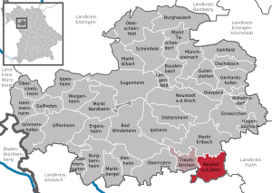
| Location of the Neuhof adZenn market in the Neustadt an der Aisch-Bad Windsheim district | ||
  |
||

Neuhof an der Zenn (officially: Neuhof adZenn ) is a market in the district of Neustadt an der Aisch-Bad Windsheim in Middle Franconia . Neuhof is the seat of the administrative community Neuhof an der Zenn .
geography
Neighboring communities
Neighboring communities are (starting from the north clockwise) Markt Erlbach , Wilhermsdorf , Dietenhofen , Rügland and Trautskirchen .
Community structure
The municipality has 14 officially named municipal parts (the type of settlement is indicated in brackets ):
|
|
|
Until the 1960s, the hammer mill (= middle mill) was an officially named part of the municipality. In the meantime it has risen in Industriestrasse.
history
West of Zennhausen, which was founded in 776, the Heilsbronn Cistercian monastery built a new cloister courtyard in 1249 , called "Noviacuria" in Latin. In 1312, the German form "ze dem Niuwen Houe" is documented for the first time, and since 1801 with the addition "an der Zenn". The place became the seat of a provost of the monastery, which administered the possessions in over a hundred places.
Neuhof belonged to the area of the Margraves of Ansbach-Bayreuth and from 1500 to the Franconian Empire .
During the Thirty Years' War , Neuhof was attacked on October 12, 1631 by a band of robbers plundering.
The Reformation took place during Hans Schmidt's tenure as pastor of Trautskirchen and Neuhof . Towards the end of the 18th century there were 80 properties in Neuhof (2 taverns, 2 blacksmiths, 2 gatehouses, 1 brewery, 1 brickyard, 2 courtyards, 1 half courtyard, 11 estates, 1 estate, 30 houses, 24 small houses, 1 mill). The high court exercised the Brandenburg-Bayreuth municipal bailiff's office in Markt Erlbach . The Neuhof caste office held the village and community rulership as well as the lordship over all properties .
In 1792 it came to Prussia and in 1810 to the Kingdom of Bavaria . As part of the municipal edict, the Neuhof an der Zenn tax district was formed in 1811 , to which Adelsdorf, Dietrichshof, Eichenmühle, Hammermühle, Neuhof, Neuselingsbach, Neuziegenrück, Oberfeldbrecht, Rothenhof, Stöckach rechts der Zenn , Straussmühle, Unterfeldbrecht, Vockenroth and Ziegelhütte belonged. In 1813 the municipality of Neuhof was formed, to which Adelsdorf, Dietrichshof, Eichenmühle, Hammermühle, Neuselingsbach, Neuziegenrück, Rothenhof, Stöckach right der Zenn, Straussmühle, Vockenroth and Ziegelhütte belonged. With the second community edict (1818) three rural communities were formed:
- Rural community of Adelsdorf with Dietrichshof;
- Rural community Neuhof with oak mill, hammer mill, Stöckach on the right of the Zenn, Straussmühle, Vockenroth and Ziegelhütte;
- Rural community Neuziegenrück with Neuselingsbach.
The municipality of Neuhof was subordinate to the district court of Markt Erlbach in administration and jurisdiction and to the Ipsheim rent office for financial administration . On January 4, 1824, the rural community of Adelsdorf was re-incorporated into the rural community of Neuhof, and Stöckach, left of the Zenn and Einersdorf, was reassigned from the rural community of Buch to Neuhof. On October 30, 1851, Einersdorf and Stöckach were finally reunited to Trautskirchen .
From 1862 Neuhof was administered by the Neustadt an der Aisch district office (from 1938: Neustadt an der Aisch district ) and from 1856 by the Markt Erlbach rent office (1920–1929: Markt Erlbach tax office , from 1929: Fürth tax office ). The jurisdiction remained with the district court of Markt-Erlbach until 1879, 1880–1959 district court of Markt Erlbach , from 1959 district court of Fürth . The community originally had an area of 11,450 km².
The village was heavily shelled by American artillery in April 1945. Seven civilians and three German soldiers were killed. 75 houses, 62 barns and 90 outbuildings were totally destroyed.
Incorporations
On January 1, 1970, the previously independent community of Neuziegenrück was incorporated. On January 1, 1972, Hirschneuses and Oberfeldbrecht were added. The district of Neukatterbach of the dissolved municipality of Katterbach followed on July 1, 1972.
Population development
In the period from 1988 to 2018, the population increased from 1,755 to 2,162 by 407 inhabitants or by 23.2%.
Neuhof an der Zenn community
| year | 1818 | 1840 | 1852 | 1861 | 1867 | 1871 | 1875 | 1880 | 1885 | 1890 | 1895 | 1900 | 1905 | 1910 | 1919 | 1925 | 1933 | 1939 | 1946 | 1950 | 1961 | 1970 | 1987 | 2005 | 2010 | 2015 |
|---|---|---|---|---|---|---|---|---|---|---|---|---|---|---|---|---|---|---|---|---|---|---|---|---|---|---|
| Residents | 738 | 1048 | 983 | 954 | 929 | 912 | 912 | 900 | 901 | 888 | 894 | 852 | 908 | 841 | 836 | 851 | 843 | 806 | 835 | 1006 | 917 | 1181 | 1756 | 2106 | 2073 | 2082 |
| Houses | 107 | 151 | 150 | 163 | 162 | 163 | 149 | 163 | 471 | 654 | ||||||||||||||||
| source |
Part of the municipality Neuhof an der Zenn
| year | 1818 | 1840 | 1861 | 1871 | 1885 | 1900 | 1925 | 1950 | 1961 | 1970 | 1987 | 2017 |
|---|---|---|---|---|---|---|---|---|---|---|---|---|
| Residents | 651 + | 733 | 762 | 737 | 732 | 694 | 691 | 783 | 726 | 894 † | 1050 * | 1311 * |
| Houses | 93 + | 102 | 133 | 133 | 135 | 128 | 133 | 265 * | ||||
| source |
politics
Market council
The 2020 local elections led to the following distribution of seats in the municipal council (compared to the 2014 election):
- CSU / Free Citizens 8 seats (−2)
- Alliance 90 / The Greens 3 seats (+2)
- Citizen-friendly list 3 seats (± 0)
badges and flags
Neuhof an der Zenn has had a coat of arms since the 18th century.
|
|
Blazon : “Standing in gold on green ground, a black wild man with a green wreath of leaves and a green leaf apron, who holds a standing green hop stick with his left hand and puts his right on a shield under a floating green hop vine; in it two diagonally crossed silver wolf irons in red, angled on both sides and below by a six-pointed golden star . "
Red and white municipal flag |
| Justification of the coat of arms: The vines were interpreted in 1835 as hop vines, which should point to the local hop cultivation. The wild man appears in older pictures as a shield holder, in Hupp he is completely absent. The wild man has been part of the coat of arms since 1951 and is no longer a shield holder. The figures in the label are interpreted differently. |
Architectural monuments
traffic
The state road 2255 runs southwest to Oberfeld Brecht or north over Neuziegenrück to Erlbach . The state road 2413 runs west of Trautskirchen and northeast of Adelsdorf over to State Street in 2252 one kilometer east of Wilhermsdorf . The circuit road 10 NEA extends south-east at the Ziegelhuette and Strauss mill over after Hirsch Neuses . Communal roads lead to Unterfeldbrecht , Vockenroth , Neuselingsbach and Eichenmühle .
literature
- Johann Kaspar Bundschuh : Neuhof . In: Geographical Statistical-Topographical Lexicon of Franconia . tape 3 : I-Ne . Verlag der Stettinische Buchhandlung, Ulm 1801, DNB 790364301 , OCLC 833753092 , Sp. 755-756 ( digitized version ).
- Emanuel Feiler: Neuhof adZenn, portrait of a Franconian market in the light of German history , Neuhof adZenn, 1999.
- Emanuel Feiler: Neuhof adZenn 1945, fate and design of a Franconian market town , Neuhof adZenn, 1995.
- Hanns Hubert Hofmann : Neustadt-Windsheim (= Historical Atlas of Bavaria, part of Franconia . I, 2). Commission for Bavarian State History, Munich 1953, DNB 452071216 , p. 115 ( digitized version ). Ibid. S. 204 ( digitized version ).
- Georg Paul Hönn : Neuhof . In: Lexicon Topographicum of the Franconian Craises . Johann Georg Lochner, Frankfurt and Leipzig 1747, p. 276 ( digitized version ).
- Georg Muck: History of Heilsbronn Monastery from prehistoric times to modern times . tape 2 . For Kunstreprod. Schmidt, Neustadt an der Aisch 1993, ISBN 3-923006-90-X , p. 339–356 (first edition: Beck, Nördlingen 1879).
- Wolf-Armin von Reitzenstein : Lexicon of Franconian place names. Origin and meaning . Upper Franconia, Middle Franconia, Lower Franconia. CH Beck, Munich 2009, ISBN 978-3-406-59131-0 , p. 158 .
- Hans Sponholz et al. (Ed.): District Neustadt an der Aisch . Verl. F. Authorities and Economy Hoeppner, Aßling-Pörsdorf / Obb. 1972, DNB 720137675 , p. 115-117 .
- Richard Strobel: District Neustadt an der Aisch (= Bavarian art monuments . Volume 32 ). Deutscher Kunstverlag, Munich 1972, DNB 730125742 , p. 88-89 .
- Pleikard Joseph Stumpf : Neuhof an der Zenn . In: Bavaria: a geographical-statistical-historical handbook of the kingdom; for the Bavarian people . Second part. Munich 1853, p. 714 ( digitized version ).
Web links
- Neuhof adZenn in the Topographia Franconiae of the University of Würzburg , accessed on September 20, 2019.
- Website of the Neuhof adZenn market
- Neuhof an der Zenn: Official statistics of the LfStat
Individual evidence
- ↑ "Data 2" sheet, Statistical Report A1200C 202041 Population of the municipalities, districts and administrative districts 1st quarter 2020 (population based on the 2011 census) ( help ).
- ↑ community Neuhof adZenn in the location database of the Bavarian State Library Online . Bayerische Staatsbibliothek, accessed on September 20, 2019.
- ↑ W.-A. v. Reitzenstein, p. 158.
- ^ Max Döllner : History of the development of the city of Neustadt an der Aisch up to 1933. Ph. C. W. Schmidt, Neustadt a. d. Aisch 1950; New edition ibid 1978, ISBN 3-87707-013-2 , p. 237.
- ↑ Max Döllner : History of the development of the city of Neustadt an der Aisch until 1933. Ph. CW Schmidt, Neustadt ad Aisch 1950. (New edition 1978 on the occasion of the 150th anniversary of the publishing house Ph. CW Schmidt Neustadt an der Aisch 1828-1978. ) P. 194.
- ↑ HH Hofmann, p. 115.
- ^ Address and statistical manual for the Rezatkreis in the Kingdom of Baiern . Buchdruckerei Chancellery, Ansbach 1820, p. 32–34 ( digitized version ). HH Hofmann p. 225.
- ↑ So HH Hofmann, p. 204. According to Eduard Vetter (Ed.): Statistical handbook and address book of Middle Franconia in the Kingdom of Bavaria . Brügel'sche Officin, Ansbach 1856, p. 122 ( digitized version ). Einersdorf and Stöckach were still districts of Neuhof in 1856.
- ↑ a b c Bavarian State Statistical Office (ed.): Official city directory for Bavaria, territorial status on October 1, 1964 with statistical information from the 1961 census . Issue 260 of the articles on Bavaria's statistics. Munich 1964, DNB 453660959 , Section II, Sp. 806 ( digitized version ).
- ^ Theodor Georg Richert: Neuhof an der Zenn in April 1945 . In: Fürther Heimatblätter . tape 17 , no. 5 . Schmidt, Neustadt / Aisch 1967.
- ^ Wilhelm Volkert (ed.): Handbook of Bavarian offices, communities and courts 1799–1980 . CH Beck, Munich 1983, ISBN 3-406-09669-7 , p. 536 .
- ↑ a b Only inhabited houses are given. In 1818 these were designated as fireplaces , in 1840 as houses , and from 1871 to 2015 as residential buildings.
- ↑ a b Alphabetical index of all the localities contained in the Rezatkreise according to its constitution by the newest organization: with indication of a. the tax districts, b. Judicial Districts, c. Rent offices in which they are located, then several other statistical notes . Ansbach 1818, p. 63 ( digitized version ). For the community of Neuhof plus the residents of Eichenmühle (p. 4), Hammermühle (p. 36), Stöckach right der Zenn (p. 89), Straussmühle (p. 90) and Vockenroth (p. 98).
- ^ A b Eduard Vetter (Ed.): Statistical handbook and address book of Middle Franconia in the Kingdom of Bavaria . Self-published, Ansbach 1846, p. 97-98 ( digitized version ).
- ↑ a b c d e f g h i j k l Bavarian State Statistical Office (Hrsg.): Historical municipality directory: The population of the municipalities of Bavaria from 1840 to 1952 (= contributions to Statistics Bavaria . Issue 192). Munich 1954, DNB 451478568 , p. 179 , urn : nbn: de: bvb: 12-bsb00066439-3 ( digitized ).
- ↑ a b Joseph Heyberger, Chr. Schmitt, v. Wachter: Topographical-statistical manual of the Kingdom of Bavaria with an alphabetical local dictionary . In: K. Bayer. Statistical Bureau (Ed.): Bavaria. Regional and folklore of the Kingdom of Bavaria . tape 5 . Literary and artistic establishment of the JG Cotta'schen Buchhandlung, Munich 1867, Sp. 1061 , urn : nbn: de: bvb: 12-bsb10374496-4 ( digitized version ).
- ↑ a b Kgl. Statistical Bureau (ed.): Complete list of localities of the Kingdom of Bavaria. According to districts, administrative districts, court districts and municipalities, including parish, school and post office affiliation ... with an alphabetical general register containing the population according to the results of the census of December 1, 1875 . Adolf Ackermann, Munich 1877, 2nd section (population figures from 1871, cattle figures from 1873), Sp. 1227–1228 , urn : nbn: de: bvb: 12-bsb00052489-4 ( digitized version ).
- ↑ a b K. Bayer. Statistical Bureau (Ed.): Localities directory of the Kingdom of Bavaria. According to government districts, administrative districts, ... then with an alphabetical register of locations, including the property and the responsible administrative district for each location. LIV. Issue of the contributions to the statistics of the Kingdom of Bavaria. Munich 1888, Section III, Sp. 1161 ( digitized version ).
- ↑ a b K. Bayer. Statistical Bureau (Ed.): Directory of localities of the Kingdom of Bavaria, with alphabetical register of places . LXV. Issue of the contributions to the statistics of the Kingdom of Bavaria. Munich 1904, Section II, Sp. 1235 ( digitized version ).
- ↑ a b Bavarian State Statistical Office (ed.): Localities directory for the Free State of Bavaria according to the census of June 16, 1925 and the territorial status of January 1, 1928 . Issue 109 of the articles on Bavaria's statistics. Munich 1928, Section II, Sp. 1273 ( digitized version ).
- ↑ a b Bavarian State Statistical Office (ed.): Official place directory for Bavaria - edited on the basis of the census of September 13, 1950 . Issue 169 of the articles on Bavaria's statistics. Munich 1952, DNB 453660975 , Section II, Sp. 1099-1100 ( digitized version ).
- ↑ a b Bavarian State Statistical Office (Hrsg.): Official local directory for Bavaria . Issue 335 of the articles on Bavaria's statistics. Munich 1973, DNB 740801384 , p. 176 ( digitized version ).
- ↑ a b Bavarian State Office for Statistics and Data Processing (Ed.): Official local directory for Bavaria, territorial status: May 25, 1987 . Issue 450 of the articles on Bavaria's statistics. Munich November 1991, DNB 94240937X , p. 341 ( digitized version ).
- ↑ a b Neuhof an der Zenn: Official statistics of the LfStat
- ↑ www.neuhof-zenn.de
- ^ Entry on the coat of arms of Neuhof an der Zenn in the database of the House of Bavarian History
- ↑ Neuhof an der Zenn. In: Kommunalflaggen.eu. Retrieved May 5, 2020 .

Bad Windsheim | Baudenbach | Burgbernheim | Burghaslach | Dachsbach | Diespeck | Dietersheim | Emskirchen | Ergersheim | Gallmersgarten | Gerhardshofen | Gollhofen | Gutenstetten | Hagenbüchach | Hemmersheim | Illesheim | Ippesheim | Ipsheim | Langenfeld | Marktbergel | Bibart Market | Market Erlbach | Market Nordheim | Market Taschendorf | Münchsteinach | Neuhof an der Zenn | Neustadt an der Aisch | Oberickelsheim | Obernzenn | Oberscheinfeld | Scheinfeld | Simmershofen | Sugenheim | Trautskirchen | Uehlfeld | Uffenheim | Weigenheim | Wilhelmsdorf