
Gerhardshofen
| coat of arms | Germany map | |
|---|---|---|

|
Coordinates: 49 ° 38 ' N , 10 ° 41' E |
|
| Basic data | ||
| State : | Bavaria | |
| Administrative region : | Middle Franconia | |
| County : | Neustadt an der Aisch-Bad Windsheim | |
| Management Community : | Uehlfeld | |
| Height : | 288 m above sea level NHN | |
| Area : | 27.21 km 2 | |
| Residents: | 2491 (Dec. 31, 2019) | |
| Population density : | 92 inhabitants per km 2 | |
| Postal code : | 91466 | |
| Area code : | 09163 | |
| License plate : | NEA, SEF, UFF | |
| Community key : | 09 5 75 125 | |
| LOCODE : | DE GOY | |
| Community structure: | 14 parts of the community | |
| Address of the municipal administration: |
Marktplatz 1 91466 Gerhardshofen |
|
| Website : | ||
| Mayor : | Jürgen Mönius ( Citizen List / CSU ) | |
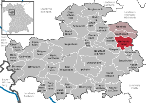
| Location of the municipality of Gerhardshofen in the district of Neustadt an der Aisch-Bad Windsheim | ||
  |
||

Gerhardshofen is a municipality in the district of Neustadt an der Aisch-Bad Windsheim in Middle Franconia .
geography
Geographical location
The community is located in the lower Aischgrund .
Neighboring communities
Neighboring communities are (starting from the north clockwise): Dachsbach , Weisendorf , Oberreichenbach , Emskirchen , Diespeck and Gutenstetten .
Community structure
The municipality has 14 officially named municipal parts (the type of settlement is indicated in brackets ):
|
|
Aichen , Burgstall , Sengersberg and Wiesenmühle are deserted areas in the municipality of Gerhardshofen and Ziegelhütte is now officially part of the Willmersbach municipality.
history
The place owes its origin to the Franconian settlement of the 9th century when forest stations were set up to clear the forest and is therefore a Carolingian foundation . During the time of the tribal duchies , Gerhardshofen was in the Duchy of Franconia .
In 1235 the place was first mentioned in a document as "Gerharteshouen". The place name contains the personal name Gerhard , who can be seen as the founder of the place. Heinrich Neze von Gerhardshofen of the Nuremberg burgrave was named in two other documents .
The Lords of Seckendorff received half a tithe from the Würzburg bishop Andreas von Gundelfingen . In 1300 Arnold von Seckendorff sold the gradient from the forge in Gerhardshofen to Heilsbronn Monastery . In 1304 he had the blacksmith Conrad Stahel buy himself out. In 1317/22 the Seckendorffers had tithes of three fields and one meadow. In the castle Count Urbar of 1361/64 is recorded that the castle Count's Office Dachsbach the Fraisch had "Gerotshouen". Subsequently, the Dachsbach office belonged to the Margraviate of Bayreuth . In the Salbuch of 1434 it is recorded that half the tithe and the small tithe in Gerhardshofen belonged to the Dachsbach office.
In the First Margrave War (1449–1450), the Nuremberg people robbed 118 cows and 17 field horses from Gerhardshofen and Dachsbach.
In 1458 there was a court seat in “Geraltzhoffen”. Around 1500, in addition to the margraves, the lords of Lüchau von Brunn , the lords of Auracher von Birnbaum, the imperial city of Nuremberg and the Birkenfeld monastery were wealthy. In 1535 the 53 existing estates belonged to the Brunn manor, to the margravial offices of Dachsbach and Neustadt an der Aisch, and to the monastery offices of Birkenfeld and Münchsteinach . In the Thirty Years' War almost all the houses were destroyed, the church burned down. Gerhardshofen was looted in autumn 1631. In 1697 there were already 44 farms again, the number of which rose to 57 by 1792. This was probably not least due to the Protestant religious expellees from Austria, who settled here after 1648 and made a significant contribution to the reconstruction of their new home.
Although the place belonged to the Dachsbach High Court , the Brunn rulers exercised this right on their property themselves.
One church was probably destroyed as early as 1450, the foundation stone for a new building was laid in 1471, and the new building was inaugurated in 1481. In 1632, Gerhardshofen was looted and pillaged in the Thirty Years' War. The major structural damage caused by the Thirty Years' War was not repaired until the end of the 17th century. A renovation in 1795 in the Margravial Baroque style was almost like a new building. Today, after another renovation, the church is a gem in the Aischgrund.
At the end of the 18th century there were 57 properties in Gerhardshofen. The high court exercised partly the Brandenburg-Bayreuth caste and jurisdiction office Dachsbach , partly the rule of Brunn . The rulership of Brunn held the village and community rulership. The landlords were the Principality of Bayreuth (31 properties; Dachsbach caste and jurisdiction office: 1 brewery and tavern, 1 tavern, 5 estates, 1 Sölde , 1 forge, 1 free house ; Birkenfeld monastery : 1 inn, 1 estate, 4 semi-estates, 1 house ; Münchsteinach monastery office : 1 courtyard, 3 goods, 3 Sölden; Neustadt an der Aisch box office : 4 drip farms ; Birnbaum administration : 2 farms), the parish of Gerhardshofen (5 farms) and the lordship of Brunn (18 houses, 3 craft houses).
In 1810 Gerhardshofen came to the new Kingdom of Bavaria . As part of the community edict, Gerhardshofen was assigned to the Dachsbach tax district in 1811 . In 1813 the rural community Gerhardshofen was formed, to which the towns of Forst and Vahlenmühle belonged. With the second community edict (1818), Eckenhof was transferred from the rural community Pahres to Gerhardshofen and Kleehof from the rural community Birnbaum . The rural community Gerhardshofen was subordinate to the regional court Neustadt an der Aisch in administration and jurisdiction and in the financial administration to the Rentamt Neustadt an der Aisch (renamed in 1920 to Finanzamt Neustadt an der Aisch ). In the voluntary jurisdiction, however, 21 properties were subordinate to the Patrimonial Court of Brunn . From 1862 Gerhardshofen was administered by the Neustadt an der Aisch district office ( renamed Neustadt an der Aisch district in 1938 ). The jurisdiction remained with the district court Neustadt an der Aisch until 1879, from 1880 district court Neustadt an der Aisch . The municipality had an area of 9.918 km².
The social democratic teacher Oechslein, who had organized a public meeting of the Republican Reich Federation in Dachsbach, was an example of the resistance against the strengthening of the ideology of the NSDAP in the Gerhardshofen / Dachsbach area .
Incorporations
On July 1, 1971, the previously independent communities of Birnbaum, Göttelhöf, Kästel and Willmersbach were incorporated. On January 1, 1972, parts of the dissolved community Reinhardshofen were added.
Population development
In the period from 1988 to 2018, the population increased from 1,407 to 2,483 by 1,076 residents or by 76.5% - the second-highest percentage increase in a municipality in the Neustadt an der Aisch-Bad Windsheim district in the period mentioned after Hagenbüchach .
Gerhardshofen community after the regional reform
| year | 1987 * | 2007 | 2009 | 2010 | 2011 * | 2012 | 2013 | 2014 | 2015 | 2016 | 2017 | 2018 |
|---|---|---|---|---|---|---|---|---|---|---|---|---|
| Residents | 1389 | 2055 | 2563 | 2539 | 2507 | 2497 | 2499 | 2516 | 2529 | 2508 | 2479 | 2483 |
| Houses | 404 | 765 | 772 | 772 | 781 | |||||||
| source |
Gerhardshofen community before the regional reform
| year | 1818 | 1840 | 1852 | 1861 | 1867 | 1871 | 1875 | 1880 | 1885 | 1890 | 1895 | 1900 | 1905 | 1910 | 1919 | 1925 | 1933 | 1939 | 1946 | 1950 | 1961 | 1970 |
|---|---|---|---|---|---|---|---|---|---|---|---|---|---|---|---|---|---|---|---|---|---|---|
| Residents | 473 | 569 | 520 | 490 | 505 | 491 | 481 | 477 | 503 | 467 | 459 | 425 | 441 | 409 | 414 | 402 | 375 | 336 | 494 | 484 | 428 | 413 |
| Houses | 98 | 99 | 86 | 91 | 89 | 86 | 86 | 92 | ||||||||||||||
| source |
Part of the municipality Gerhardshofen
| year | 1818 | 1840 | 1861 | 1871 | 1885 | 1900 | 1925 | 1950 | 1961 | 1970 | 1987 | 2016 |
|---|---|---|---|---|---|---|---|---|---|---|---|---|
| Residents | 342 | 417 | 379 | 355 | 365 | 318 | 291 | 343 | 328 | 313 | 416 | 1169 |
| Houses | 69 | 73 | 69 | 68 | 67 | 66 | 73 | 134 | ||||
| source |
politics
The community is a member of the Uehlfeld administrative community .
Municipal council
The 2020 local elections resulted in the following distribution of seats in the local council:
Distribution of seats between the parties
| year | voter turnout | CSU | Free voters | Truth and justice | Active in the future | Preserving the old - shaping the future | Participate and help shape | Citizen List | Young voters | Citizens Forum |
|---|---|---|---|---|---|---|---|---|---|---|
| 2008 | 4th | - | 3 | 2 | 1 | 1 | 2 | 1 | - | |
| 2014 | 66.13% | 3 | - | 2 | 2 | 1 | 1 | 2 | 1 | 1 |
| 2020 | 64.96% | 5 | 3 | 2 | 2 | 1 | 1 | - | - | - |
coat of arms
The municipality of Geroldshofen has had a coat of arms since 1976.
|
|
Blazon : " Divided by red and silver, above a growing silver lion , below a black key and a fallen black sword crossed diagonally." |
| Justification of the coat of arms: The lion's body comes from the coat of arms of the extinct Bleymann von Laufenberg, who made a name for themselves in the 17th century for the places Birnbaum and Gerhardshofen as well as for the church itself. The red and silver tinging refers to older ownership of the Würzburg bishopric , which owned goods and tithe in the named places in the 14th century. The sword and key as attributes of St. Peter and Paul refer to the Protestant church of the same name in Gerhardshofen, which is to be regarded as a local landmark. The colors silver and black indicate the color of the coat of arms of the Margraves of Zoller Ansbach-Bayreuth, who were sovereigns for what is now the municipality. |
The first mayor is Jürgen Mönius.
Culture and sights
music
- Men's choir Eintracht Gerhardshofen
- Youth band Evangelica
- Youth band Hangman
Architectural monuments
Regular events
- Parish fair in Gerhardshofen on the penultimate Sunday in August
- The village festival takes place every two years.
- The wine festival of the volunteer fire brigade has been taking place on the weekend of Pentecost since 2017.
traffic
The federal highway 470 runs southwest to Diespeck and northeast to Dachsbach . The state road 2259 runs east to Birnbaum . Communal roads lead to Eckenhof and Willmersbach .
The municipality belongs to the tariff area of the VGN .
literature
- Johann Kaspar Bundschuh : Gerhardshofen . In: Geographical Statistical-Topographical Lexicon of Franconia . tape 2 : El-H . Verlag der Stettinische Buchhandlung, Ulm 1800, DNB 790364298 , OCLC 833753081 , Sp. 303 ( digitized version ).
- Hanns Hubert Hofmann : Neustadt-Windsheim (= Historical Atlas of Bavaria, part of Franconia . I, 2). Commission for Bavarian State History, Munich 1953, DNB 452071216 , p. 97 ( digitized version ). Ibid. S. 185 ( digitized version ).
- Georg Muck: History of Heilsbronn Monastery from prehistoric times to modern times . tape 2 . For Kunstreprod. Schmidt, Neustadt an der Aisch 1993, ISBN 3-923006-90-X , p. 328 (first edition: Beck, Nördlingen 1879).
- Wolf-Armin von Reitzenstein : Lexicon of Franconian place names. Origin and meaning . Upper Franconia, Middle Franconia, Lower Franconia. CH Beck, Munich 2009, ISBN 978-3-406-59131-0 , p. 81 .
- Hans Sponholz et al. (Ed.): District Neustadt an der Aisch . Verl. F. Authorities and Economy Hoeppner, Aßling-Pörsdorf / Obb. 1972, DNB 720137675 , p. 96-97 .
- Richard Strobel: District Neustadt an der Aisch (= Bavarian art monuments . Volume 32 ). Deutscher Kunstverlag, Munich 1972, DNB 730125742 , p. 69-73 .
Web links
- Local government
- Gerhardshofen in the Topographia Franconiae of the University of Würzburg , accessed on September 20, 2019.
- Gerhardshofen: Official statistics of the LfStat
Individual evidence
- ↑ "Data 2" sheet, Statistical Report A1200C 202041 Population of the municipalities, districts and administrative districts 1st quarter 2020 (population based on the 2011 census) ( help ).
- ^ Community Gerhardshofen in the local database of the Bavarian State Library Online . Bayerische Staatsbibliothek, accessed on September 20, 2019.
- ^ Max Döllner : History of the development of the city of Neustadt an der Aisch up to 1933. Ph. CW Schmidt, Neustadt ad Aisch 1950, p. 18 f.
- ↑ W.-A. v. Reitzenstein, p. 81.
- ↑ a b H. Sponholz (Ed.), P. 96.
- ↑ G. Muck, Vol. 2, p. 328.
- ↑ H. Sponholz (Ed.), P. 97.
- ↑ Max Döllner (1950), p. 237.
- ↑ Eberhard Krauss: Exulanten im Evang.-Luth. Deanery Neustadt an der Aisch. Nuremberg 2012 (sources and research on Franconian family history, 27), passim. ISBN 978-3-929865-32-5
- ^ Max Döllner : History of the development of the city of Neustadt an der Aisch up to 1933. Ph. C. W. Schmidt, Neustadt a. d. Aisch 1950, OCLC 42823280 ; New edition to mark the 150th anniversary of the Ph. C. W. Schmidt publishing house, Neustadt an der Aisch 1828–1978. Ibid 1978, ISBN 3-87707-013-2 , p. 243.
- ↑ HH Hofmann, p. 97.
- ^ Address and statistical manual for the Rezatkreis in the Kingdom of Baiern . Buchdruckerei Chancellery, Ansbach 1820, p. 59 ( digitized version ). HH Hofmann p. 221.
- ↑ HH Hofmann, p. 185.
- ↑ a b c Bavarian State Statistical Office (ed.): Official city directory for Bavaria, territorial status on October 1, 1964 with statistical information from the 1961 census . Issue 260 of the articles on Bavaria's statistics. Munich 1964, DNB 453660959 , Section II, Sp. 804 ( digitized version ).
- ^ Wolfgang Mück: Nazi stronghold in Middle Franconia. The Volkish Awakening in Neustadt ad Aisch 1922–1933. Schmidt, Neustadt an der Aisch 2016 (= Streiflichter aus der Heimatgeschichte. Ed. By Geschichts- und Heimatverein Neustadt ad Aisch e.V., special volume 4), 3rd, extended edition ibid. 2016, ISBN 978-3-87707-990- 4 , pp. 141-143.
- ^ Wilhelm Volkert (ed.): Handbook of Bavarian offices, communities and courts 1799–1980 . CH Beck, Munich 1983, ISBN 3-406-09669-7 , p. 536 .
- ↑ a b c Only inhabited houses are given. In 1818 these were designated as fireplaces , in 1840 as houses , and from 1871 to 2017 as residential buildings.
- ↑ a b Bavarian State Office for Statistics and Data Processing (Ed.): Official local directory for Bavaria, territorial status: May 25, 1987 . Issue 450 of the articles on Bavaria's statistics. Munich November 1991, DNB 94240937X , p. 339 ( digitized version ).
- ↑ a b c d e f g h i j k LfStat: Gemeinde Gerhardshofen 09 575 125.Bavarian State Office for Statistics, March 2020, accessed on April 5, 2020 .
- ↑ a b Alphabetical index of all the localities contained in the Rezatkreise according to its constitution by the newest organization: with indication of a. the tax districts, b. Judicial Districts, c. Rent offices in which they are located, then several other statistical notes . Ansbach 1818, p. 29 ( digitized version ). For the municipality of Gerhardshofen plus the residents and buildings of Eckenhof (p. 20), Forst (p. 26), Kleehof (p. 48) and Vahlenmühle (p. 97).
- ^ A b Eduard Vetter (Ed.): Statistical handbook and address book of Middle Franconia in the Kingdom of Bavaria . Self-published, Ansbach 1846, p. 198 ( digitized version ).
- ↑ a b c d e f g h i j k l Bavarian State Statistical Office (Hrsg.): Historical municipality directory: The population of the municipalities of Bavaria from 1840 to 1952 (= contributions to Statistics Bavaria . Issue 192). Munich 1954, DNB 451478568 , p. 179 , urn : nbn: de: bvb: 12-bsb00066439-3 ( digitized ).
- ↑ a b Joseph Heyberger, Chr. Schmitt, v. Wachter: Topographical-statistical manual of the Kingdom of Bavaria with an alphabetical local dictionary . In: K. Bayer. Statistical Bureau (Ed.): Bavaria. Regional and folklore of the Kingdom of Bavaria . tape 5 . Literary and artistic establishment of the JG Cotta'schen Buchhandlung, Munich 1867, Sp. 1056 , urn : nbn: de: bvb: 12-bsb10374496-4 ( digitized version ).
- ↑ a b Kgl. Statistical Bureau (ed.): Complete list of localities of the Kingdom of Bavaria. According to districts, administrative districts, court districts and municipalities, including parish, school and post office affiliation ... with an alphabetical general register containing the population according to the results of the census of December 1, 1875 . Adolf Ackermann, Munich 1877, 2nd section (population figures from 1871, cattle figures from 1873), Sp. 1221 , urn : nbn: de: bvb: 12-bsb00052489-4 ( digitized ).
- ↑ a b K. Bayer. Statistical Bureau (Ed.): Localities directory of the Kingdom of Bavaria. According to government districts, administrative districts, ... then with an alphabetical register of locations, including the property and the responsible administrative district for each location. LIV. Issue of the contributions to the statistics of the Kingdom of Bavaria. Munich 1888, Section III, Sp. 1155 ( digitized version ).
- ↑ a b K. Bayer. Statistical Bureau (Ed.): Directory of localities of the Kingdom of Bavaria, with alphabetical register of places . LXV. Issue of the contributions to the statistics of the Kingdom of Bavaria. Munich 1904, Section II, Sp. 1228 ( digitized version ).
- ↑ a b Bavarian State Statistical Office (ed.): Localities directory for the Free State of Bavaria according to the census of June 16, 1925 and the territorial status of January 1, 1928 . Issue 109 of the articles on Bavaria's statistics. Munich 1928, Section II, Sp. 1265-1266 ( digitized version ).
- ↑ a b Bavarian State Statistical Office (ed.): Official place directory for Bavaria - edited on the basis of the census of September 13, 1950 . Issue 169 of the articles on Bavaria's statistics. Munich 1952, DNB 453660975 , Section II, Sp. 1097 ( digitized version ).
- ↑ a b Bavarian State Statistical Office (Hrsg.): Official local directory for Bavaria . Issue 335 of the articles on Bavaria's statistics. Munich 1973, DNB 740801384 , p. 175 ( digitized version ).
- ↑ Population figures on the gerhardshofen.de website
- ^ A b District Neustadt ad Aisch - Bad Windsheim: municipal elections. Retrieved April 2, 2020 .
- ^ Entry on the Gerhardshofen coat of arms in the database of the House of Bavarian History
- ↑ Greetings. Municipality of Gerhardshofen, accessed on July 18, 2020 .

Bad Windsheim | Baudenbach | Burgbernheim | Burghaslach | Dachsbach | Diespeck | Dietersheim | Emskirchen | Ergersheim | Gallmersgarten | Gerhardshofen | Gollhofen | Gutenstetten | Hagenbüchach | Hemmersheim | Illesheim | Ippesheim | Ipsheim | Langenfeld | Marktbergel | Bibart Market | Market Erlbach | Market Nordheim | Market Taschendorf | Münchsteinach | Neuhof an der Zenn | Neustadt an der Aisch | Oberickelsheim | Obernzenn | Oberscheinfeld | Scheinfeld | Simmershofen | Sugenheim | Trautskirchen | Uehlfeld | Uffenheim | Weigenheim | Wilhelmsdorf