
Brunn (Emskirchen)
|
Well
Emskirchen market
Coordinates: 49 ° 34 ′ 22 " N , 10 ° 42 ′ 34" E
|
|
|---|---|
| Height : | 348–366 m above sea level NHN |
| Residents : | 463 (May 25 1987) |
| Incorporation : | January 1, 1972 |
| Postal code : | 91448 |
| Area code : | 09104 |
Brunn is a district of the Emskirchen market in the Neustadt an der Aisch-Bad Windsheim district in Middle Franconia .
geography
The Mühlbach flows through the parish village and joins the Moorgraben (right) to form the Floresbach, a left tributary of the Middle Aurach . In the northwest are the Brunner ponds. Approx. The Schloßfeld is located 0.5 km west of the village, the Pfaffenzipfel forest area approx. 0.5 km south-west, the Mühlberg rises approx. 0.5 km south-east, the Glashütte corridor area approx. 0.5 km north, approx , 5 km to the east are the Röten.
The national road 2414 leads to Hohholz (2.5 km north) or after Emskirchen to State Road 8 (km south 2). The district road NEA 22 leads to the B 8 (2 km south-west) or to the state road 2244 at the snow mill (2.2 km south-east). The district road NEA 11 leads to Oberalbach (1.2 km northeast). Communal roads lead to Kaltenneuses (1.8 km northwest) and Weihermühle (0.8 km southeast).
history

The place was first mentioned in 1154/57 as a " fountain " in a document in which the Heilsbronn monastery exchanged goods in this and other places for goods in other places. In 1164 the monastery acquired goods in Brunn. A slope was acquired under the 12th Abbot Rudolf (1263–81). In 1279, Siboto Grötsch gave Grötsch a slope in Brunn in order to acquire a grave in the monastery . In 1344 the siblings Hermann, Hans and Sophia von Löpsingen gave up their farm in Brunn.
In a document dated July 7, 1265 it is mentioned that there is a "werenherus de Brv o nne", from which it can be concluded that there was already a local nobility at that time. In 1311 the monastery sold its goods to Wolfram von Urach. From 1400 the castle was owned by the von Seckendorff family . Brunn Palace was burned down in 1409 (a second time in 1501). In 1486 half of the village was given to Heinrich von Lüchau as a fief, the other half to the Bamberg monastery . In 1517 the place came into the possession of the Limpurg taverns , but the fraish authorities held the margravial office of Emskirchen. From 1559 to the early 18th century, the place belonged largely to the Lords of Heßberg , and from May 24, 1753 to the Counts of Pückler-Limpurg .
During the Thirty Years War , Brunn was sacked in autumn 1631. The nobleman von Lüchau, who resided in Brunn and was in Swedish service as a colonel, had the Neustadt Kastner Moenius and the mayor Meder arrested in 1638, because the contributions imposed by Lüchau were not raised in time, and held them in Brunn until Neustadt its mayor triggered (Moenius, however, had to finance his release from his own resources).
Towards the end of the 18th century there were 50 properties in Brunn (castle with dairy, church, office building, rectory, school, gardener's house, hunter's house, cellar house, shepherd's house, 2 blacksmiths, 2 taverns, 1 brick factory, 16 small estates, 20 houses, 1 small house ) and a community shepherd's house. The high court and the village and community rulership and the lordship over all properties exercised the rule of Brunn.The lordship of Brunn belonged to Count v. Pückler and the Limpurg taverns . They exercised the high court and the village and community rule over Gerhardshofen (partly), Hohholz and Tanzenhaid . In addition to the 50 properties in Brunn, they were also landlords in Altenbuch (1 property), Gerhardshofen (21), Hohholz (13) and Tanzenhaid (7).

Evangelical Lutheran Parish Church of St. George
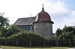
Old castle


In 1810 Brunn came to the new Kingdom of Bavaria . As part of the municipal edict , the Brunn tax district was formed in 1811 , to which Hohholz , Kaltenneuses , Tanzenhaid , Kotzenaurach , Vierzehnmorgen and Weihermühle belonged. In 1813 the rural community of Brunn was formed, which was congruent with the tax district. With the second community edict (1818), the rural community was split into
- Rural community of Brunn with Weihermühle;
- Rural community Hoholz with Kaltenneuses, Tanzenhaid and Vierzehnmorgen.
The rural community of Brunn was under the patrimonial court of Brunn directly and only indirectly in administration and jurisdiction to the district court of Markt Erlbach and in the financial administration to the Neustadt an der Aisch rent office . The voluntary jurisdiction and the police were held by the Patrimonial Court until 1833, and the Patrimonial Office in Brunn from 1833 to 1848.
From 1862 Brunn was administered by the Neustadt an der Aisch district office (renamed Neustadt an der Aisch district in 1938 ) and from 1856 by the Markt Erlbach rent office (1920–1929: Markt Erlbach tax office , from 1929: Neustadt an der Aisch tax office ). The jurisdiction remained until 1879 with the district court of Markt Erlbach, 1880–1959 district court of Markt Erlbach , from 1959 district court of Fürth . The municipality had an area of 4.853 km².
On January 1, 1972, Brunn was incorporated into Emskirchen as part of the regional reform .
Population development
Brunn municipality
| year | 1818 | 1840 | 1852 | 1855 | 1861 | 1867 | 1871 | 1875 | 1880 | 1885 | 1890 | 1895 | 1900 | 1905 | 1910 | 1919 | 1925 | 1933 | 1939 | 1946 | 1950 | 1952 | 1961 | 1970 |
|---|---|---|---|---|---|---|---|---|---|---|---|---|---|---|---|---|---|---|---|---|---|---|---|---|
| Residents | 344 | 450 | 474 | 479 | 465 | 502 | 482 | 480 | 477 | 491 | 443 | 469 | 442 | 467 | 455 | 427 | 430 | 460 | 458 | 608 | 666 | 620 | 516 | 521 |
| Houses | 64 | 76 | 79 | 89 | 85 | 86 | 89 | 100 | ||||||||||||||||
| source |
Place Brunn
| year | 1818 | 1840 | 1861 | 1871 | 1885 | 1900 | 1925 | 1950 | 1961 | 1970 | 1987 |
|---|---|---|---|---|---|---|---|---|---|---|---|
| Residents | 344 | 444 | 455 | 475 | 484 | 436 | 430 | 664 | 514 | 518 | 463 |
| Houses | 64 | 75 | 88 | 84 | 85 | 88 | 99 | 133 | |||
| source |
Architectural monuments
- Landmarks of the former Count Pückler High Court District
- New lock
- barn
- Old castle
- seven boundary stones of the former Count Pückler's Niederjagddistrikt
- Evangelical Lutheran parish church of St. Georg
literature
- Johann Kaspar Bundschuh : Brunn . In: Geographical Statistical-Topographical Lexicon of Franconia . tape 1 : A-egg . Verlag der Stettinische Buchhandlung, Ulm 1799, DNB 790364298 , OCLC 833753073 , Sp. 455 ( digitized version ).
- Hanns Hubert Hofmann : Neustadt-Windsheim (= Historical Atlas of Bavaria, part of Franconia . I, 2). Commission for Bavarian State History, Munich 1953, DNB 452071216 , p. 85 ( digitized version ). Ibid. S. 197 ( digitized version ).
- Georg Muck: History of Heilsbronn Monastery from prehistoric times to modern times . tape 2 . For Kunstreprod. Schmidt, Neustadt an der Aisch 1993, ISBN 3-923006-90-X , p. 325 (first edition: Beck, Nördlingen 1879).
- Hans Sponholz et al. (Ed.): District Neustadt an der Aisch . Verl. F. Authorities and Economy Hoeppner, Aßling-Pörsdorf / Obb. 1972, DNB 720137675 , p. 80-81 .
- Richard Strobel: District Neustadt an der Aisch (= Bavarian art monuments . Volume 32 ). Deutscher Kunstverlag, Munich 1972, DNB 730125742 , p. 37-40 .
- Pleikard Joseph Stumpf : Well . In: Bavaria: a geographical-statistical-historical handbook of the kingdom; for the Bavarian people . Second part. Munich 1853, p. 713 ( digitized version ).
Web links
- Brunn in the location database of the Bayerische Landesbibliothek Online . Bavarian State Library
- Brunn in the Topographia Franconiae of the University of Würzburg , accessed on September 20, 2019.
- Brunn in the historical directory of the association for computer genealogy
Individual evidence
- ↑ a b Bavarian State Office for Statistics and Data Processing (Ed.): Official local directory for Bavaria, territorial status: May 25, 1987 . Issue 450 of the articles on Bavaria's statistics. Munich November 1991, DNB 94240937X , p. 339 ( digitized version ).
- ↑ Brunn in the Bavaria Atlas
- ↑ G. Muck, Volume 1, p. 47 f.
- ↑ Manfred Jehle: Ansbach: the margravial chief offices of Ansbach, Colmberg-Leutershausen, Windsbach, the Nuremberg nursing office Lichtenau and the Deutschordensamt (Wolframs-) Eschenbach (= Historical Atlas of Bavaria, part of Franconia . I, 35). tape 1 . Commission for Bavarian State History, Munich 2009, ISBN 978-3-7696-6856-8 , p. 371 .
- ↑ G. Muck, Volume 1, p. 75.
- ↑ G. Muck, Volume 2, p. 325.
- ^ Max Döllner : History of the development of the city of Neustadt an der Aisch until 1933. Ph. CW Schmidt, Neustadt an der Aisch 1950; Reprinted ibid 1978, p. 60.
- ↑ H. Sponholz (Ed.), P. 81 f. HH Hofmann, p. 26.
- ↑ Max Döllner (1950), pp. 237 and 250.
- ↑ HH Hofmann, p. 85.
- ^ HH Hofmann, p. 69.
- ^ Address and statistical manual for the Rezatkreis in the Kingdom of Baiern . Buchdruckerei Chancellery, Ansbach 1820, p. 32 ( digitized version ). HH Hofmann p. 223.
- ↑ HH Hofmann, p. 197.
- ↑ a b c Bavarian State Statistical Office (ed.): Official city directory for Bavaria, territorial status on October 1, 1964 with statistical information from the 1961 census . Issue 260 of the articles on Bavaria's statistics. Munich 1964, DNB 453660959 , Section II, Sp. 803 ( digitized version ).
- ^ Wilhelm Volkert (ed.): Handbook of Bavarian offices, communities and courts 1799–1980 . CH Beck, Munich 1983, ISBN 3-406-09669-7 , p. 535 .
- ↑ a b Only inhabited houses are given. In 1818 these were designated as fireplaces , in 1840 as houses and from 1871 to 1987 as residential buildings.
- ↑ a b Alphabetical index of all the localities contained in the Rezatkreise according to its constitution by the newest organization: with indication of a. the tax districts, b. Judicial Districts, c. Rent offices in which they are located, then several other statistical notes . Ansbach 1818, p. 13 ( digitized version ).
- ^ A b Eduard Vetter (Ed.): Statistical handbook and address book of Middle Franconia in the Kingdom of Bavaria . Self-published, Ansbach 1846, p. 99 ( digitized version ).
- ↑ a b c d e f g h i j k l m n Bavarian State Statistical Office (Hrsg.): Historical municipality register: The population of the municipalities of Bavaria from 1840 to 1952 (= contributions to Statistics Bavaria . Issue 192). Munich 1954, DNB 451478568 , p. 179 , urn : nbn: de: bvb: 12-bsb00066439-3 ( digitized ).
- ↑ a b Joseph Heyberger, Chr. Schmitt, v. Wachter: Topographical-statistical manual of the Kingdom of Bavaria with an alphabetical local dictionary . In: K. Bayer. Statistical Bureau (Ed.): Bavaria. Regional and folklore of the Kingdom of Bavaria . tape 5 . Literary and artistic establishment of the JG Cotta'schen Buchhandlung, Munich 1867, Sp. 1059 , urn : nbn: de: bvb: 12-bsb10374496-4 ( digitized version ).
- ↑ a b Kgl. Statistical Bureau (ed.): Complete list of localities of the Kingdom of Bavaria. According to districts, administrative districts, court districts and municipalities, including parish, school and post office affiliation ... with an alphabetical general register containing the population according to the results of the census of December 1, 1875 . Adolf Ackermann, Munich 1877, 2nd section (population figures from 1871, cattle figures from 1873), Sp. 1225 , urn : nbn: de: bvb: 12-bsb00052489-4 ( digitized ).
- ↑ a b K. Bayer. Statistical Bureau (Ed.): Localities directory of the Kingdom of Bavaria. According to government districts, administrative districts, ... then with an alphabetical register of locations, including the property and the responsible administrative district for each location. LIV. Issue of the contributions to the statistics of the Kingdom of Bavaria. Munich 1888, Section III, Sp. 1159 ( digitized version ).
- ↑ a b K. Bayer. Statistical Bureau (Ed.): Directory of localities of the Kingdom of Bavaria, with alphabetical register of places . LXV. Issue of the contributions to the statistics of the Kingdom of Bavaria. Munich 1904, Section II, Sp. 1231 ( digitized version ).
- ↑ a b Bavarian State Statistical Office (ed.): Localities directory for the Free State of Bavaria according to the census of June 16, 1925 and the territorial status of January 1, 1928 . Issue 109 of the articles on Bavaria's statistics. Munich 1928, Section II, Sp. 1269 ( digitized version ).
- ↑ a b Bavarian State Statistical Office (ed.): Official place directory for Bavaria - edited on the basis of the census of September 13, 1950 . Issue 169 of the articles on Bavaria's statistics. Munich 1952, DNB 453660975 , Section II, Sp. 1095 ( digitized version ).
- ↑ a b Bavarian State Statistical Office (Hrsg.): Official local directory for Bavaria . Issue 335 of the articles on Bavaria's statistics. Munich 1973, DNB 740801384 , p. 175 ( digitized version ).

Altschauerberg | Borbath | Bottenbach | Brunn | Book blades | Dürrnbuch | Eckenberg | Elgersdorf | Emskirchen (with brickworks ) | Fall Mastery | Finkenmühle | Airfield | Grieshof | Gunzendorf | Hohholz (with brick hut ) | Cold new | Guide mill | Mausdorf | Neidhardswinden | Neuschauerberg | Oberniederndorf | Pirkach | Plankstatt | Prackenhof | Rennhofen | Riedelhof | Snow mill | Sixtmühle | Tanzenhaid | Weihermühle | Wulkersdorf