
Uffenheim
| coat of arms | Germany map | |
|---|---|---|

|
Coordinates: 49 ° 33 ' N , 10 ° 14' E |
|
| Basic data | ||
| State : | Bavaria | |
| Administrative region : | Middle Franconia | |
| County : | Neustadt an der Aisch-Bad Windsheim | |
| Management Community : | Uffenheim | |
| Height : | 329 m above sea level NHN | |
| Area : | 59.47 km 2 | |
| Residents: | 6502 (Dec. 31, 2019) | |
| Population density : | 109 inhabitants per km 2 | |
| Postal code : | 97215 | |
| Area code : | 09842 | |
| License plate : | NEA, SEF, UFF | |
| Community key : | 09 5 75 168 | |
| City structure: | 13 parts of the community | |
City administration address : |
Marktplatz 16 97215 Uffenheim |
|
| Website : | ||
| Mayor : | Wolfgang Lampe ( SPD ) | |
| Location of the city of Uffenheim in the district of Neustadt an der Aisch-Bad Windsheim | ||
  |
||


Uffenheim is a town in the Neustadt an der Aisch-Bad Windsheim district in Central Franconia ( Bavaria ). It is the seat of the Uffenheim administrative community .
geography
Geology and landscape
Geologically, Uffenheim lies in the slightly bent sediment layers of the Lower Keuper . They consist of clays and marls with limestone and sandstone banks . The sandstone in the middle of the sequence is several meters thick. In the east of the city there is an arching center of the Uffenheimer saddle. The limestones of the Upper Muschelkalks below the Keuper are cut up to 20 meters by the Gollach, which flows from east to west . They were dismantled in the area of the Upper Mill. The greater hardness of the shell limestone rock results in steeper valley cuts of the Gollach and its tributaries compared to the surrounding area. During the Ice Ages, large parts of the relief were covered with loess . The fertile soils that have developed there are the basis for the strong agricultural character of the landscape. Uffenheim is located in the Gollachgau , which together with the Ochsenfurt Gau, which is very similar in terms of landscape, forms the main natural spatial unit of the Ochsenfurt Gau and Gollachgau , which lies within the Main Franconian plateau .
The climate is humid all year round with average rainfall of 644 mm per year and average temperatures around 8.3 ° C.
Neighboring communities
Neighboring communities are (clockwise from the north): Weigenheim , Markt Nordheim , Ergersheim , Gallmersgarten , Ohrbach , Adelshofen , Simmershofen , Gollhofen .
Community structure
The municipality has 13 officially named municipality parts (the type of settlement is indicated in brackets ):
|
|
history
Until the 19th century
Mentioned for the first time in 1103, Uffenheim received town charter from Emperor Charles IV under the nobles of Hohenlohe in 1349. In 1378 the city was sold to the Burgraves of Nuremberg = Margraves of Ansbach. The margraves (= Hohenzollern) introduced the Reformation as early as 1528. From 1500 the margraviate was in the Franconian Empire . From 1791 to 1806 the Franconian margravates and thus also Uffenheim were Prussian territory, whereby the Baron von Hardenberg tried his famous reforms in this area as well.
Since 1806 the city belonged to the Kingdom of Bavaria. In the decades of industrialization, Uffenheim remained a small town and the center of the fertile Gollachgau .
Starting in 1848, Middle Franconia was divided into four studs and Uffenheim and Neustadt formed the fourth of them.
20th century
The prominent keynote speakers were Gregor Strasser and Julius Streicher on September 9, 1928 at a rally by the NSDAP with the participation of the Neustädter Sturm 20 in Uffenheim. In the same year the Uffenheimer Tageblatt became. Independent, national farmers and medium- sized newspaper founded by the Scheinfeld restaurateur and politician Wilhelm Holzwarth with Theo Holzwarth. In 1930 Frieda Saueracker, née Schuh, complained to Julius Streicher from Ermetzhofen about the "harmful influence of the Holzwarthsche Zeitung" on the NSDAP . After the editorial offices were destroyed by local National Socialists with an explosive device, Wilhelm Holzwarth left Uffenheim in 1932. The Uffenheim district , which existed until July 1, 1972, has belonged to the Neustadt an der Aisch district since the regional reform (from May 1, 1973 Neustadt an der Aisch-Bad Windsheim district ). Due to supraregional transport connections and improvements in the infrastructure, Uffenheim has been upgraded to a possible medium- sized center .
Incorporations
On January 1, 1972, the previously independent communities Brackenlohr (with Aspachhof), Rudolzhofen and Welbhausen were incorporated. On July 1, 1972, Custenlohr (with Hinterpfeinach and Vorderpfeinach ) was added. Uttenhofen followed on January 1, 1978. The series of incorporations was completed on May 1, 1978 with the incorporation of Langensteinach (with Kleinharbach ) and Wallmersbach.
Population development
In the period from 1988 to 2018, the population rose from 5640 to 6518 by 878 inhabitants or 15.6%.
politics
City council
The city council consists of 20 members. In the city council election on March 15, 2020, the result led to the following distribution of seats:
| Party / list | Seats |
| CSU | 7th |
| SPD | 5 |
| GREEN | 2 |
| FWG | 3 |
| Citizen List | 3 |
mayor
Wolfgang Lampe (SPD) was elected the new mayor in the second ballot in March 2014 and was confirmed with 63% in March 2020.
coat of arms
Blazon : Split; in the front quartered in silver and black, in the back a red-armored golden lion in black.
Town twinning
religion
Uffenheim is home to the following Christian communities:
- Ev.-luth. Deanery District Uffenheim (since 1556)
- Ev.-luth. Parish of Uffenheim
- Ev.-luth. Parish of Langensteinach
- Ev.-luth. Wallmersbach parish
- Ev.-luth. Parish Seenheim-Ermetzhofen (for the districts of Custenlohr, Rudolzhofen, Pfeinach)
- Ev.-luth. Parish Simmershofen (for the districts Aspachhof, Brackenlohr)
- Ev.-luth. Parish Ulsenheim (for the Uttenhofen district)
- Regional Church Community Uffenheim (LKG)
- Roman Catholic Parish Herz Jesu Uffenheim
Culture and sights
Museums
- Local history museum ( Gollachgau museum ): palaeontological collection (fossil plants and animals from the area), prehistoric finds from the Stone Age to the Iron Age, Hallstatt Age, biblical collection from the 17th and 18th centuries, books from the 17th to the 19th centuries, hand-colored maps ( 17th – 18th century), a Franconian farmer's room and an old kitchen. A specialty is the Uffenheim pharmacy , the oldest in Germany, and a drug collection from 1786. A militaria collection includes rifles, helmets and edged weapons from the 18th and 19th centuries as well as equipment from the two world wars.
music
- Some men's and women's choirs, also from the area - specializing in Franconian-rural folk songs
- Choir of the Christian von Bomhard School
- Orchestra of the Christian von Bomhard School
- Big band from the Christian von Bomhard School
- Singing ensemble Half Ten (male quintet)
- Vocabella vocal ensemble
- Shady Glamor - rock / pop band
- Choir of the ev.-luth. Dean's District Uffenheim
- Trumpet choir of the ev.-luth. Parish of Uffenheim
- ProCheck choir of the ev.-luth. Dean's District Uffenheim
Buildings

- Castle, former moated castle, rebuilt after a fire in the 17th century. After the renovation work in 2006, part of the palace was used by the tax office, which also uses the new building opposite.
- ev.-luth. City church St. Johannis, around 1730, destroyed in 1945, rebuilt in 1953, renovation in 1988
- ev.-luth. Hospital Church, around 1360
- ev.-luth. Dean's office, around 1730
- Cemetery with Jobstkapelle
- ev. House of the Church, former Royal Bavarian District Court from 1901
- Scherenhof, important Franconian half-timbered house with bay window, 1571
- Remains of the city wall with towers
- Old post from 1709
- upper mill from 1776
Architectural monuments
Sports
- Darts Club Uffenheim ( Sligo Power )
- Football Club Uffenheim ( 1.FV Uffenheim )
- Reitverein Uffenheim ( Riding and Driving Club Uffenheim )
- Shooting Club Uffenheim ( Royal Private Shooting Society Uffenheim )
- Sports club Bomhardschule Uffenheim ( SBU )
- Tanzsportverein Uffenheim ( TSC Uffenheim )
- Tennis Club Uffenheim ( TC Uffenheim )
- Gymnastics Club Uffenheim ( TV Uffenheim )
- Association for German Shepherds ( Schäferhundeverein Uffenheim )
Economy and Infrastructure
traffic
Uffenheim station is on the Treuchtlingen – Würzburg railway line . There are hourly trains to Ansbach (journey time 31 minutes) and Würzburg (journey time 34 minutes).
The federal highway 13 runs through Uffenheim, the federal highway 7 is a short distance away .
The Franconian Marienweg leads through the village.
Established businesses
In the industrial area north of the Treuchtlingen-Würzburg railway is adidas resident - in the distribution center of goods delivery for Europe takes place. The XXXL central warehouse, Mömax Logistik , as well as companies for mechanical engineering, packaging technology, the manufacture of ship floors and ship equipment, as well as forest technology can be found in the industrial area on federal highway 7 .
Public facilities
- Ev.-luth. Dean's office and parish office
- Tax office Formerly housed in the moated castle, now in the new building opposite. The move prompted the city of Uffenheim to extensive expansion of the parking spaces and access roads.
- Uffenheim hospital closed since August 2013, psychosomatic clinic (Heiligenfeld) since 2014
- Office for Food, Agriculture and Forests Uffenheim
education
- The Christian-von-Bomhard-Schule is a state-recognized substitute school with church sponsorship. She is a member of the Evangelical School Foundation in Bavaria. Gymnasium, secondary school and technical college for social affairs are all under one roof. There is a boarding school near the school for girls and boys who attend one of the schools. The school was founded in 1531.
- State elementary school (elementary and middle school)
- Frieda Lang House for Children (private primary school)
- Daycare center Am Obstgarten
- Ev.-luth. Kindergarten St. Johannis
- Ev.-luth. Karoline Kolb day care center
- Ev.-luth. Welbhausen kindergarten
Personalities
- Johann Lukas Boër , actually Boogers (1751–1835), doctor, obstetrician and university professor
- Johann Friedrich Christoph Bauer (1803–1873), politician and Protestant theologian
- Karl Arnold (1853–1929), chemist, mineralogist and university professor
- Friedrich Ehrlicher (1908–1993), teacher, chairman of the Bavarian Youth Hostel Association and president of the German Unitarian religious community.
- Harro Frey (1942–2011), sculptor
- Jacob Friedrich Georgii (1697–1762), Protestant theologian and Uffenheim dean (from 1729), author of the "Uffenheim auxiliary hours"
- Friedrich Grieninger (1835–1915), Mayor of Uffenheim from 1862 to 1875, member of the Reichstag and Landtag
- Karl Hillermeier (1922–2011), lawyer and politician (CSU), member of the Bavarian State Government from 1966 to 1988; Deputy Prime Minister from 1977 to 1988
- Georg Hofmann (1923–2012), politician (CSU), district administrator
- Wilhelm Holzwarth (born September 15, 1875 in Scheinfeld, † 1941 in Frankfurt am Main), founder and editor of the Uffenheimer Tageblatt
- Julius Sämann (1911–1999), perfumer and chemist ; Inventor of the wonder tree
- Friedrich Karl Gottlob Hirsching (1762–1800), author of reference works
- Conz Schott von Schottenstein († 1526) margravial bailiff, spent his first years in Uffenheim
- Alexander Thumfart (* 1959), political scientist
- Friedrich Wencker-Wildberg (1896–1970), writer and farmer

lock
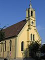
Hospital Church

Scherenhof

Ansbach Gate

Wurzburg Gate

Old post


literature
- JA Bullnheimer: History of Uffenheim: along with historical notes about its near and distant surroundings , Ansbach: Brügel 1905.
- Johann Kaspar Bundschuh : Uffenheim . In: Geographical Statistical-Topographical Lexicon of Franconia . tape 5 : S-U . Verlag der Stettinische Buchhandlung, Ulm 1802, DNB 790364328 , OCLC 833753112 , Sp. 600-606 ( digitized version ).
- Walter Gebert u. a .: Uffenheim from the beginning - archaeological excavations at the pig market . Verlag Seehars, Uffenheim 1999
- Max Haber, Friedrich Wencker-Wildberg : Six hundredth anniversary of the city of Uffenheim , Würzburg: Richter 1949.
- Heinz Hillermeier (Ed.): Uffenheim - City and Country; Forays into the history of our Franconian homeland . Verlag Seehars, Uffenheim 2004
- Gerhard Rechter: Uffenheim. History of the houses from 1530 to 1945. Nuremberg 2003 (sources and research on Franconian family history, 12), ISBN 978-3-929865-06-6
- Godehard Schramm , Ottmar Fick: Uffenheim and its Gollachgau. Black and white illustrated book; Verlag Seehars, Uffenheim 1989
- City of Uffenheim (Ed.): 650 years of Uffenheim , Uffenheim 1999.
- Gottfried Stieber: Uffenheim . In: Historical and topographical news from the Principality of Brandenburg-Onolzbach . Johann Jacob Enderes, Schwabach 1761, p. 833-854 ( digitized version ).
- Gottfried Stieber: Walmersbach . In: Historical and topographical news from the Principality of Brandenburg-Onolzbach . Johann Jacob Enderes, Schwabach 1761, p. 898-904 ( digitized version ).
- Pleikard Joseph Stumpf : Uffenheim . In: Bavaria: a geographical-statistical-historical handbook of the kingdom; for the Bavarian people . Second part. Munich 1853, p. 763-764 ( digitized version ).
- Uffenheim history and stories. Volumes 1-9; Wencker-Wildberg-Verlag, Uffenheim
- Uffenheim in old views. Wencker-Wildberg-Verlag, Uffenheim
Web links
- City of Uffenheim
- Uffenheim in the Topographia Franconiae of the University of Würzburg , accessed on September 25, 2019.
- Entry on the coat of arms of Uffenheim in the database of the House of Bavarian History
Individual evidence
- ↑ "Data 2" sheet, Statistical Report A1200C 202041 Population of the municipalities, districts and administrative districts 1st quarter 2020 (population based on the 2011 census) ( help ).
- ↑ Bayerisches Geologisches Landesamt (Ed.), 1976: Geological map of Bavaria 1: 25,000 sheet No. 6327/6427, Markt Einersheim / Uffenheim, explanations. By Hellmut Haunschild.
- ↑ Bavarian Geological State Office (ed.), 1996: Geological map of Bavaria 1: 500,000. 4. rework. Ed., Munich.
- ↑ bfn.de
- ^ Johannes Müller: Basic features of the natural geography of Lower Franconia. (= Franconian landscape 1). Justus Perthes Verlag, Gotha 1996. p. 77.
- ^ Community Uffenheim in the local database of the Bavarian State Library Online . Bayerische Staatsbibliothek, accessed on September 25, 2019.
- ^ Max Döllner : History of the development of the city of Neustadt an der Aisch up to 1933. Ph. CW Schmidt, Neustadt ad Aisch 1950. (New edition 1978 on the occasion of the 150th anniversary of the Ph. CW Schmidt Neustadt an der Aisch publishing house 1828-1978. ) P. 440.
- ^ Heinz Hillermeier (ed.): Uffenheim city and country. Forays into the history of our Franconian homeland. Uffenheim 2004, p. 211.
- ^ Wolfgang Mück: Nazi stronghold in Middle Franconia: The völkisch awakening in Neustadt an der Aisch 1922–1933. Verlag Philipp Schmidt, 2016 (= Streiflichter from home history. Special volume 4); ISBN 978-3-87707-990-4 , pp. 31, 82 and 259 f.
- ^ Wilhelm Volkert (ed.): Handbook of Bavarian offices, communities and courts 1799–1980 . CH Beck, Munich 1983, ISBN 3-406-09669-7 , p. 583 .
- ^ Federal Statistical Office (ed.): Historical municipality directory for the Federal Republic of Germany. Name, border and key number changes in municipalities, counties and administrative districts from May 27, 1970 to December 31, 1982 . W. Kohlhammer, Stuttgart / Mainz 1983, ISBN 3-17-003263-1 , p. 723 .
- ↑ statistik.bayern.de Statistics Bavaria - local elections
- ↑ Archived copy ( memento of the original from April 25, 2010 in the Internet Archive ) Info: The archive link was automatically inserted and not yet checked. Please check the original and archive link according to the instructions and then remove this notice.
- ^ Website of the Christian von Bomhard School

Bad Windsheim | Baudenbach | Burgbernheim | Burghaslach | Dachsbach | Diespeck | Dietersheim | Emskirchen | Ergersheim | Gallmersgarten | Gerhardshofen | Gollhofen | Gutenstetten | Hagenbüchach | Hemmersheim | Illesheim | Ippesheim | Ipsheim | Langenfeld | Marktbergel | Bibart Market | Market Erlbach | Market Nordheim | Market Taschendorf | Münchsteinach | Neuhof an der Zenn | Neustadt an der Aisch | Oberickelsheim | Obernzenn | Oberscheinfeld | Scheinfeld | Simmershofen | Sugenheim | Trautskirchen | Uehlfeld | Uffenheim | Weigenheim | Wilhelmsdorf