
Münchsteinach
| coat of arms | Germany map | |
|---|---|---|

|
Coordinates: 49 ° 38 ' N , 10 ° 36' E |
|
| Basic data | ||
| State : | Bavaria | |
| Administrative region : | Middle Franconia | |
| County : | Neustadt an der Aisch-Bad Windsheim | |
| Management Community : | Diespeck | |
| Height : | 299 m above sea level NHN | |
| Area : | 29.47 km 2 | |
| Residents: | 1312 (Dec. 31, 2019) | |
| Population density : | 45 inhabitants per km 2 | |
| Postal code : | 91481 | |
| Area code : | 09166 | |
| License plate : | NEA, SEF, UFF | |
| Community key : | 09 5 75 150 | |
| LOCODE : | DE M9S | |
| Community structure: | 8 parts of the community | |
| Address of the municipal administration: |
Kirchenweg 6 91481 Münchsteinach |
|
| Website : | ||
| Mayor : | Jürgen Riedel ( New Forum ) | |
| Location of the community Münchsteinach in the district of Neustadt an der Aisch-Bad Windsheim | ||
  |
||


Münchsteinach is a municipality in the district of Neustadt an der Aisch-Bad Windsheim in Middle Franconia . She is a member of the Diespeck administrative association .
geography
Geographical location
The community is located in the southeast of the Steigerwald Nature Park, around 40 km northwest of Nuremberg and around 50 km southeast of Würzburg .
Neighboring communities
The neighboring communities are:
(clockwise, starting in the north)
Community structure
The municipality has eight officially named municipality parts (the type of settlement is indicated in brackets ):
|
|
The Agel and Schneidmühle are not officially designated parts of the municipality.
history

Until the church is planted
In Münchsteinach, described for the first time in 1832, there are remains of a burial mound from the Hallstatt period (around 500 BC), the so-called "Celtic area". At the beginning of the 21st century, a so-called Celtic tree circle was created in the Münchsteinach community forest and a Celtic barrow was built (the historical graves are no longer visible).
912 it is mentioned in a document that King Konrad I gave the abbot Dracholf of the Schwarzach u. a. gives the place "Steinaha". Accordingly, the place would originally have been a royal estate. However, it is unclear whether “Steinaha” means Münchsteinach or Steinach an der Ens . In 1102 the Lords of Steinach founded the Steinach Benedictine monastery . The first clear evidence can be found in a document that must have been created between 1103 and 1139. Here the place is called "Steina". The place name is derived from the name of the water body of the same name, which describes a stony stream.
The bailiwick of the monastery came to the burgraves of Nuremberg and later margraves of Brandenburg-Kulmbach via King Konradin at the latest in 1265 . During the time of the tribal duchies, the place was in the Duchy of Franconia . Buried in the monastery church in 1347 was Konrad Heider von Dachsbach, who was in office as monastery bailiff from 1298 and was mentioned in documents as early as 1294 as bailiff of Neustadt. The church and monastery were destroyed in the Peasants' War in 1525 , the monastery was secularized in the course of the Reformation in 1528 and a margravial monastery office was established there, which existed until 1792. Münchsteinach has been a Protestant parish and an independent parish since 1530. During the Thirty Years' War there were also assaults, looting and arson, torture and the murder of Pastor Waldmann in Münchsteinach. After the end of the Thirty Years' War, numerous Protestant religious expellees from Austria settled here, who made a significant contribution to the reconstruction of their new home. From December 10, 700 to 1732, the Münchsteinach monastery office (together with Schornweisach, Gutenstetten and Baudenbach) was pledged by the margrave to the diocese of Würzburg. The redemption took place against payment of 280,000 guilders.
Towards the end of the 18th century there were 48 properties in Münchsteinach (office building, church, rectory, 1 courtyard, 1 half-yard, 2 hubs , 3 mills, 1 forge, 1 tavern, 1 bath room, 8 goods, 2 half-goods, 2 small estates, 13th century Sölden , 1 semi-estate, 2 drip houses , 2 half drip houses, 4 houses, 2 half houses). The high court was exercised by the Brandenburg-Bayreuth city bailiff Neustadt an der Aisch . The Brandenburg-Bayreuth Monastery Office Münchsteinach held the village and community rulership and the land rulership over all properties .
Through the Paris Treaty of 1810 under Napoleon , Münchsteinach fell to France as part of the Prussian principality of Bayreuth in the Peace of Tilsit in 1807 and was ceded to Bavaria in 1810. As part of the municipal edict , the Münchsteinach tax district was formed in 1811 , to which Abtsgreuth , Agelmühle , Höfen , Mittelsteinach , Mönchsberg , Roßbach , Undungsmühle and Weihermühle belonged. In 1813 the rural community Münchsteinach was formed, which was congruent with the tax district. With the second community edict (1818), the rural community was split into
- Rural community Abtsgreuth with Mittelsteinach and Undungsmühle;
- Rural community Mönchsberg with courtyards;
- Rural community Münchsteinach with Agel and Weiher mill;
- Rural community of Roßbach.
It was subordinate to the regional court Neustadt an der Aisch in administration and jurisdiction and in the financial administration to the Rentamt Neustadt an der Aisch (renamed in 1920 to Finanzamt Neustadt an der Aisch ). From 1862 Münchsteinach was administered by the Neustadt an der Aisch district office ( renamed Neustadt an der Aisch district in 1938 ). The jurisdiction remained with the district court Neustadt an der Aisch until 1879, from 1880 district court Neustadt an der Aisch . The municipality had an area of 6.647 km².
Incorporations
On January 1, 1972, the previously independent communities Abtsgreuth and Neuebersbach and parts of the dissolved community of Altershausen were incorporated.
Population development
In the period from 1988 to 2018, the population fell from 1,359 to 1,339 by 20 residents or 1.5%.
Münchsteinach community
| year | 1818 | 1840 | 1852 | 1861 | 1867 | 1871 | 1875 | 1880 | 1885 | 1890 | 1895 | 1900 | 1905 | 1910 | 1919 | 1925 | 1933 | 1939 | 1946 | 1950 | 1961 | 1970 | 1987 | 2007 | 2012 | 2016 | ||
|---|---|---|---|---|---|---|---|---|---|---|---|---|---|---|---|---|---|---|---|---|---|---|---|---|---|---|---|---|
| Residents | 425 | 491 | 479 | 462 | 476 | 504 | 515 | 506 | 559 | 565 | 534 | 510 | 505 | 534 | 495 | 481 | 476 | 507 | 481 | 703 | 673 | 636 | 584 | 657 | 1329 | 1425 | 1369 | 1346 |
| Houses | 75 | 86 | 83 | 94 | 100 | 100 | 108 | 116 | 380 | 499 | ||||||||||||||||||
| source |
Münchsteinach part of the municipality
| year | 1818 | 1840 | 1861 | 1871 | 1885 | 1900 | 1925 | 1950 | 1961 | 1970 | 1987 |
|---|---|---|---|---|---|---|---|---|---|---|---|
| Residents | 409 | 477 | 463 | 496 | 536 | 496 | 468 | 658 | 577 | 653 | 808 |
| Houses | 72 | 84 | 89 | 98 | 98 | 106 | 114 | 214 | |||
| source |
Religions
The districts of Abtsgreuth, Neuebersbach and Münchsteinach belong to the Evangelical Lutheran parish of Münchsteinach. Altershausen has its own church, the pastor of which is in Kleinweisach. Since the two churches are the only churches in the area, good contacts are maintained with the Catholic Christians and the Catholic parish Neustadt / Aisch is supported in pastoral care in the community area. In the minster (winter church in the parish hall) there is church service every Sunday, and more recently regular evening services in a modern form.
politics
Municipal council
The Münchsteinach municipal council has twelve members without the mayor.
| Citizens Forum | Free voters retirement home | Free voters Neuebersbach | total | |
| 2014 | 8th | 3 | 1 | 12 seats |
mayor
The full-time first mayor has been Jürgen Riedel (Citizens' Forum) since May 1, 2008. Ursula Schenke (Bürgerblock) had been her predecessor since May 1, 2002.
badges and flags
The Münchsteinach community has had a coat of arms since 1956.
|
|
Blazon : “ Split by silver and gold; at the front of the gap a half, gold armored red eagle with a golden clover leaf bow on the wing, behind a standing black clad Benedictine monk. "
Red and white municipal flag |
| Reasons for the coat of arms: The half red eagle is the Brandenburg coat of arms in a reduced form. It is a reminder of the long rulership of the margraves of Brandenburg-Ansbach in Münchsteinach. The Benedictine monk has the former convent and is also talking to the place name. |
Culture and sights
Buildings
The Romanesque cathedral and the former Benedictine monastery on the Kirchberg of Münchsteinach are the sights of the Steigerwaldort . Of the monastery ensemble founded in 1102 and completed in 1180, only the abbey church of St. Nicholas is preserved, a Romanesque pillar basilica with originally two choir towers, only one of which has survived the ages. The abbey church and the convent buildings were partially destroyed in the turmoil of wars and the Reformation , and the church and monastery were later secularized. The eastern part of the church with the choir, cross arms and crossing served the evangelical parish as church space, the nave was used as a barn.
Only an extensive renovation from 1965 to 1970 allowed the room to reappear in its simple medieval beauty. The southern convent building dates from the 15th century and is now used by the community as a town hall and kindergarten.

Romanesque nave with baroque altar, Münchsteinach Minster

Romanesque eagle capital, baptistery Münchsteinacher Münster
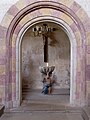
Romanesque arched passage to the baptistery
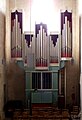
The organ in the northern cross arm of the Münchsteinach Minster

The Abtsschlösschen in the monastery district of Münchsteinach


The last abbot of the monastery, Christoph von Hirschaid, had the former abbot's palace built on the monastery grounds in 1519/20.
It was once the official building of the monastery and is now a private residence.
Architectural monuments
Sport and freetime
- Oasis of the senses in the district of Altershausen, since 2005 with "Keltenareal"
Economy and Infrastructure
traffic
Münchsteinach belongs to the transport association for the greater Nuremberg area . Bus routes 145, 146 and 148 connect the town on weekdays, and also on Sundays in summer, with the district town of Neustadt an der Aisch, about ten kilometers to the south . Neustadt (Aisch) station on the Nuremberg – Würzburg railway line is the nearest train station.
The State Road 2259 leads past the Weihermühle to Mittelsteinach or Kleinsteinach to Gutenstetten . The district road NEA 14 leads past Neuebersbach to the district road NEA 12 . A communal road leads to Mönchsberg to state road 2256 .
Established businesses
- Brauerei Loscher KG (founded in 1881), manufacturer of Club-Mate , with Brauereigasthof Krone
- ZFE GmbH, prefabricated brick elements, manufacturer of solid brick roller shutter boxes, brick ceilings, etc.
- Willner Bauunternehmung Baustoffe e. K.
Personalities
- The actor Günter Strack (1929–1999) lived and died in the community. His grave is in the community cemetery at Münchsteinach Minster.
Others
There are two parish fraternities in Münchsteinach . They are called the Loscher-Boschn and the Flory-Burschen after two of the former three breweries ( Flory was also an inn in Münchsteinach around 1930). The trombone choir in Münchsteinach has existed since 1921.

literature
- Johann Kaspar Bundschuh : Münchsteinach . In: Geographical Statistical-Topographical Lexicon of Franconia . tape 3 : I-Ne . Verlag der Stettinische Buchhandlung, Ulm 1801, DNB 790364301 , OCLC 833753092 , Sp. 679-680 ( digitized version ).
- Hanns Hubert Hofmann : Neustadt-Windsheim (= Historical Atlas of Bavaria, part of Franconia . I, 2). Commission for Bavarian State History, Munich 1953, DNB 452071216 , p. 114 ( digitized version ). Ibid. S. 187 ( digitized version ).
- Wolf-Armin von Reitzenstein : Lexicon of Franconian place names. Origin and meaning . Upper Franconia, Middle Franconia, Lower Franconia. CH Beck, Munich 2009, ISBN 978-3-406-59131-0 , p. 153 .
- Hans Sponholz et al. (Ed.): District Neustadt an der Aisch . Verl. F. Authorities and Economy Hoeppner, Aßling-Pörsdorf / Obb. 1972, DNB 720137675 , p. 111-113 .
- Richard Strobel: District Neustadt an der Aisch (= Bavarian art monuments . Volume 32 ). Deutscher Kunstverlag, Munich 1972, DNB 730125742 , p. 111-120 .
Web links
- Münchsteinach: Official statistics of the LfStat
- Münchsteinach in the Topographia Franconiae of the University of Würzburg , accessed on September 21, 2019.
- Münchsteinach in the historical directory of the association for computer genealogy
Individual evidence
- ↑ "Data 2" sheet, Statistical Report A1200C 202041 Population of the municipalities, districts and administrative districts 1st quarter 2020 (population based on the 2011 census) ( help ).
- ^ Münchsteinach community in the local database of the Bavarian State Library Online . Bavarian State Library, accessed on September 21, 2019.
- ↑ Gunter Lehrieder: The Celtic Tree Circle. In: The Steigerwald. Journal of a Franconian Landscape: Nature - Culture - History. Volume 27, No. 3 (July) 2007, pp. 27–48, here: p. 29 ( The Celts at the oases of the senses ) and 30 f. ( The Celtic Tree Circle ) and 48.
- ↑ H. Sponholz (Ed.), P. 111.
- ↑ W.-A. v. Reitzenstein, p. 153.
- ^ Max Döllner : History of the development of the city of Neustadt an der Aisch until 1933. Ph. CW Schmidt, Neustadt ad Aisch 1950, pp. 24 and 103.
- ↑ Max Döllner (1950), p. 247.
- ↑ Eberhard Krauss: Exulanten im Evang.-Luth. Deanery Neustadt an der Aisch. Nuremberg 2012 (sources and research on Franconian family history, 27), passim. ISBN 978-3-929865-32-5
- ↑ Max Döllner (1950), p. 146.
- ↑ HH Hofmann, p. 114.
- ^ Address and statistical manual for the Rezatkreis in the Kingdom of Baiern . Buchdruckerei Chancellery, Ansbach 1820, p. 58-60 ( digitized version ). HH Hofmann p. 222.
- ^ HH Hofmann, p. 187.
- ↑ a b c Bavarian State Statistical Office (ed.): Official city directory for Bavaria, territorial status on October 1, 1964 with statistical information from the 1961 census . Issue 260 of the articles on Bavaria's statistics. Munich 1964, DNB 453660959 , Section II, Sp. 806 ( digitized version ).
- ^ Wilhelm Volkert (ed.): Handbook of Bavarian offices, communities and courts 1799–1980 . CH Beck, Munich 1983, ISBN 3-406-09669-7 , p. 536 .
- ↑ a b Only inhabited houses are given. In 1818 these were designated as fireplaces , in 1840 as houses , and from 1871 to 1987 as residential buildings.
- ↑ a b Alphabetical index of all the localities contained in the Rezatkreise according to its constitution by the newest organization: with indication of a. the tax districts, b. Judicial Districts, c. Rent offices in which they are located, then several other statistical notes . Ansbach 1818, p. 61 ( digitized version ). For the municipality of Münchsteinach plus the residents and buildings of Agelmühle (p. 5) and Weihermühle (p. 101).
- ^ A b Eduard Vetter (Ed.): Statistical handbook and address book of Middle Franconia in the Kingdom of Bavaria . Self-published, Ansbach 1846, p. 200 ( digitized version ).
- ↑ a b c d e f g h i j k l Bavarian State Statistical Office (Hrsg.): Historical municipality directory: The population of the municipalities of Bavaria from 1840 to 1952 (= contributions to Statistics Bavaria . Issue 192). Munich 1954, DNB 451478568 , p. 179 , urn : nbn: de: bvb: 12-bsb00066439-3 ( digitized ).
- ↑ a b Joseph Heyberger, Chr. Schmitt, v. Wachter: Topographical-statistical manual of the Kingdom of Bavaria with an alphabetical local dictionary . In: K. Bayer. Statistical Bureau (Ed.): Bavaria. Regional and folklore of the Kingdom of Bavaria . tape 5 . Literary and artistic establishment of the JG Cotta'schen Buchhandlung, Munich 1867, Sp. 1057 , urn : nbn: de: bvb: 12-bsb10374496-4 ( digitized version ).
- ↑ a b Kgl. Statistical Bureau (ed.): Complete list of localities of the Kingdom of Bavaria. According to districts, administrative districts, court districts and municipalities, including parish, school and post office affiliation ... with an alphabetical general register containing the population according to the results of the census of December 1, 1875 . Adolf Ackermann, Munich 1877, 2nd section (population figures from 1871, cattle figures from 1873), Sp. 1222 , urn : nbn: de: bvb: 12-bsb00052489-4 ( digital copy ).
- ↑ a b K. Bayer. Statistical Bureau (Ed.): Localities directory of the Kingdom of Bavaria. According to government districts, administrative districts, ... then with an alphabetical register of locations, including the property and the responsible administrative district for each location. LIV. Issue of the contributions to the statistics of the Kingdom of Bavaria. Munich 1888, Section III, Sp. 1156 ( digitized version ).
- ↑ a b K. Bayer. Statistical Bureau (Ed.): Directory of localities of the Kingdom of Bavaria, with alphabetical register of places . LXV. Issue of the contributions to the statistics of the Kingdom of Bavaria. Munich 1904, Section II, Sp. 1229 ( digitized version ).
- ↑ a b Bavarian State Statistical Office (ed.): Localities directory for the Free State of Bavaria according to the census of June 16, 1925 and the territorial status of January 1, 1928 . Issue 109 of the articles on Bavaria's statistics. Munich 1928, Section II, Sp. 1266-1267 ( digitized version ).
- ↑ a b Bavarian State Statistical Office (ed.): Official place directory for Bavaria - edited on the basis of the census of September 13, 1950 . Issue 169 of the articles on Bavaria's statistics. Munich 1952, DNB 453660975 , Section II, Sp. 1099 ( digitized version ).
- ↑ a b Bavarian State Statistical Office (Hrsg.): Official local directory for Bavaria . Issue 335 of the articles on Bavaria's statistics. Munich 1973, DNB 740801384 , p. 176 ( digitized version ).
- ↑ a b Bavarian State Office for Statistics and Data Processing (Ed.): Official local directory for Bavaria, territorial status: May 25, 1987 . Issue 450 of the articles on Bavaria's statistics. Munich November 1991, DNB 94240937X , p. 341 ( digitized version ).
- ↑ a b c Münchsteinach: Official statistics of the LfStat
- ↑ Entry on the Münchsteinach coat of arms in the database of the House of Bavarian History
- ↑ Münchsteinach. In: Kommunalflaggen.eu. Retrieved May 22, 2020 .
- ↑ Gunter Lehrieder: The Celtic Tree Circle. In: The Steigerwald. Journal of a Franconian Landscape: Nature - Culture - History. Volume 27, No. 3 (July) 2007, pp. 27–48, here: p. 29 ( The Celts at the oases of the senses ).
- ↑ Oasis of the senses .
- ↑ Wolfgang Fleischer: Loscher Brewery grows with mate . In: Brauwelt. No. 11, 2011, p. 345 f.
- ^ Wolfgang Mück: Nazi stronghold in Middle Franconia: The völkisch awakening in Neustadt an der Aisch 1922–1933. Verlag Philipp Schmidt, 2016 (= Streiflichter from home history. Special volume 4); ISBN 978-3-87707-990-4 , p. 92.
- ↑ www.muenchsteinach-kirche.de: Trombone Choir .

Bad Windsheim | Baudenbach | Burgbernheim | Burghaslach | Dachsbach | Diespeck | Dietersheim | Emskirchen | Ergersheim | Gallmersgarten | Gerhardshofen | Gollhofen | Gutenstetten | Hagenbüchach | Hemmersheim | Illesheim | Ippesheim | Ipsheim | Langenfeld | Marktbergel | Bibart Market | Market Erlbach | Market Nordheim | Market Taschendorf | Münchsteinach | Neuhof an der Zenn | Neustadt an der Aisch | Oberickelsheim | Obernzenn | Oberscheinfeld | Scheinfeld | Simmershofen | Sugenheim | Trautskirchen | Uehlfeld | Uffenheim | Weigenheim | Wilhelmsdorf