
Erlenstegen forest

The Erlenstegen forest is a community-free area in the Central Franconian district of Erlangen-Höchstadt .
The 11.77 km² state forest is the northeast of Ziegelstein and east of Erlenstegen , both districts of Nuremberg , part of the Sebalder Reichswald . The A3 motorway runs through the area. The Haidberg is 392 m above sea level. NN the highest point, its ridge forms the northern border to Geschaidt . The federal highway 2 forms the western border with the Kraftshofer forest , the federal highway 14 and the railway line Nürnberg – Cheb the southern border. The Eichelberg junction was on the railway line , from where there was a connection to the Ringbahn .
Waters
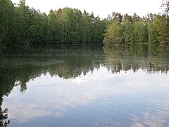
The source rivers of the Tiefgraben , the left upper reaches Haidbrunnengraben and the right upper reaches Kühgraben arise in the Erlenstegen forest . In the forest lies the Weißensee, portrayed by Albrecht Dürer in a watercolor .
Picture gallery
The Weißensee in the Erlenstegen forest

Weißensee shore area


See also
Individual evidence
- ↑ Area information at www.destatis.de, as of December 31, 2018 , accessed on August 1, 2020.
Web links
- Unregulated area of Erlenstegener Forst in OpenStreetMap (accessed on August 19, 2017)

Adelsdorf | Aurachtal | Baiersdorf | Bubenreuth | Buckenhof | Eckental | Gremsdorf | Großenseebach | Hemhofen | Heroldsberg | Herzogenaurach | Hessdorf | Höchstadt an der Aisch | Kalchreuth | Lonnerstadt | Marloffstein | Möhrendorf | Mulhouse | Oberreichenbach | Röttenbach | Savings Village | Uttenreuth | Vestenbergsgreuth | Wachenroth | Weisendorf
Unregulated areas in the district of Erlangen-Höchstadt
Birkach |
Buckenhofer Forest |
Dormitzer Forest |
Erlenstegen Forest |
Forest Tennenlohe |
Geschaidt |
Kalchreuther Forest |
Kraftshofer Forest |
Mark |
Neunhofer Forest
Coordinates: 49 ° 29 ′ 20 ″ N , 11 ° 9 ′ 30 ″ E