
Brick (nuremberg)
|
Brick
Statistical District 84 City of Nuremberg
Coordinates: 49 ° 29 ′ 24 ″ N , 11 ° 6 ′ 13 ″ E
|
|
|---|---|
| Height : | 310-320 m above sea level NHN |
| Area : | 1.94 km² |
| Residents : | 5626 (December 31, 2015) |
| Population density : | 2,900 inhabitants / km² |
| Incorporation : | August 1, 1920 |
| Postal code : | 90411 |
| Area code : | 0911 |
 Location of the statistical district 84
|
|
 Ziegelstein underground station at Fritz-Munkert-Platz
|
|
The former village of Ziegelstein was incorporated into the Middle Franconian city of Nuremberg on August 1, 1920. The suburban district is located in the northeast of Nuremberg and forms the statistical district 84 .
geography
The Ziegelstein district of Nuremberg is located northeast of downtown Nuremberg and immediately southeast of Nuremberg Airport . Neighboring districts are Buchenbühl in the north, Schafhof in the southeast, Loher Moos and Herrnhütte in the south and southwest, Marienberg and Mooshof in the west. The Hirschsprunggraben flows through the area from east to west.
| Neighboring statistical districts | |||||||||
|---|---|---|---|---|---|---|---|---|---|
|
.svg)
Statistical Districts
| District 84 Statistical Districts Brick | |||||||||
|---|---|---|---|---|---|---|---|---|---|
 |
|||||||||
|
District 841 Ziegelstein consists of the following districts:
- 840 brick south-west
- 841 brick south-east
- 842 brick north-east
- 843 brick north-west
History and present
Brick


The settlement was built next to an urban brickworks that was destroyed in the Second Margrave War. The place was formerly owned by the Nuremberg patrician family Haller , who owned a castle there, which was destroyed in 1642 and not rebuilt. In the 15th century, the name of the Ziegelstein Castle was transferred to the entire settlement, which was destroyed both in the two Margrave Wars and in the Thirty Years' War . In 1647 the place came to the Schlüsselfelder and from 1666 to 1848 to the Imhoff . The Imhoff Castle still stands today; However, the tower was destroyed by American soldiers in the Second World War and the building was badly defaced in the following years through attempts at modernization.
Towards the end of the 18th century there were 28 properties in Ziegelstein (1 castle, 1 tavern, 1 brick factory, 1 shepherd's house, 1 schoolhouse, 11 estates, 7 estates, 5 houses, 2 brandy distilleries). The high court exercised the imperial city of Nuremberg , but this was disputed by the Brandenburg-Bayreuth Oberamt Baiersdorf . The Nuremberg owner von Imhoff held the village and community rulership and the lordship over all properties .
In 1796, Ziegelstein came to Prussia and in 1810 to the Kingdom of Bavaria . As part of the municipal edict, the tax district and the rural community Großreuth were formed behind the fortress in 1813 , to which Ziegelstein also belonged. With the second community edict (1818), the rural community Ziegelstein was formed, to which Herrnhütte belonged. It was subordinate to the Erlangen Regional Court in administration and jurisdiction and to the Erlangen Rent Office for financial administration . In the voluntary jurisdiction, 24 properties from 1822 to 1848 were subordinate to the brick patrimonial court . From 1826, Ziegelstein was under the administration and jurisdiction of the Nuremberg Regional Court and the Nuremberg Rent Office ( renamed the Nuremberg Tax Office in 1920 ). From 1862, Ziegelstein was administered by the Nuremberg District Office (renamed the Nuremberg District in 1938 ). Jurisdiction has been with the Nuremberg District Court since 1880 . The municipality had an area of 2,479 km². On August 1, 1920, Ziegelstein was incorporated into the city of Nuremberg .
Cattle breeding was largely limited to beekeepers and the village commons , which are still used today as "the Anger" for circus performances and traditional festivals such as the Ziegelsteiner Kirchweih . One of the main streets, the Bierweg, is on a route that dates back to the Middle Ages and was once used to transport beer.
During the war years, weapons were manufactured on the site of what is now the Nordostpark technology park in the east of Brick. Towards the end of the war, the factories were bombed, with some bombs also hitting the nearby Reichswald east of Ziegelstein. The impact holes can still be seen.
Population development
Brick Community
| year | 1818 | 1840 | 1852 | 1855 | 1861 | 1867 | 1871 | 1875 | 1880 | 1885 | 1890 | 1895 | 1900 | 1905 | 1910 | 1919 |
|---|---|---|---|---|---|---|---|---|---|---|---|---|---|---|---|---|
| Residents | 202 | 282 | 374 | 350 | 386 | 445 | 534 | 540 | 553 | 564 | 565 | 631 | 635 | 632 | 657 | 623 |
| Houses | 49 | 44 | 67 | 75 | 81 | |||||||||||
| source |
Place brick
| year | 1818 | 1840 | 1861 | 1871 | 1885 | 1900 |
|---|---|---|---|---|---|---|
| Residents | 176 | 235 | 302 | 449 | 423 | 516 |
| Houses | 40 | 40 | 60 | 65 | ||
| source |
religion
The place has been predominantly Protestant since the Reformation. The residents of the Evangelical Lutheran denomination are parish in the Melanchthon Church , the residents of the Roman Catholic denomination are parish after St. George .
Architectural monuments

In Ziegelstein there is a Catholic parish with the St. George's Church and a large parish and youth home as well as an Evangelical Lutheran parish with the Melanchthon Church, built by German Bestelmeyer in 1938–40 . The Schafhof Gnadenkirche belongs to the Evangelical Lutheran congregation , an emergency church that was built in 1951 with an aid program by the aid organization of the Evangelical Churches in Germany . Ziegelstein has a primary and partial secondary school on Heroldsberger Weg.
Some farmhouses from the 18th and 19th centuries have been preserved. However, the residential complexes from the first half of the 20th century, which were renovated with great care, are clearly noticeable.
Customs and clubs
The brick Steiner Customs association organizes every year traditional festivals as fair, Sonnwendfeier , potato fire , Thanksgiving and Advent singing and bakes every first Saturday from March to November in self-built oven to a brick Steiner Anger wood oven bread.
Sports
There are also many other local sports clubs. For example, the former football club ASN Pfeil Nürnberg and the former handball Bundesliga club TuSpo Nürnberg are based in Ziegelstein . The Nuremberg Hockey Society was the German indoor hockey champion in 1968 and currently plays in the 1st Bundesliga. With the Club am Marienberg there is a second hockey and tennis club. The DJK professional fire brigade Franken Concordia is another football association.
traffic
city traffic
With the Herrnhütte underground station and its own Ziegelstein underground station, Ziegelstein has a direct connection to the underground , which replaced the last tram line 3 and the direct connection to the city center and the airport enables.
Furthermore, the bus lines 21, 30, 31 and 45 run through the district , offering numerous direct connections to the city area.
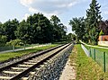
Brick stop

By Brick leading Gräfenbergbahn that short time a breakpoint Brick ⊙ at the level crossing on the road had Neuwied.
The station was opened on February 1, 1908 by the Royal Bavarian State Railways . On January 13, 1926, the station was abandoned with the extension of the tram to Ziegelstein and instead a stop was opened in the Buchenbühl district, which was newly created at the time, in the north . Since it was discontinued in 1983, the Nuremberg north-east station for Ziegelstein , located directly at Herrnhütte , has ensured the closest connection to the federal railway network .
- photos

Former platform area out of town

former platform area towards the city
former loading platform out of town

Former loading platform with overgrown ramp into town


literature
- Johann Kaspar Bundschuh : Brick . In: Geographical Statistical-Topographical Lexicon of Franconia . tape 6 : V-Z . Verlag der Stettinische Buchhandlung, Ulm 1804, DNB 790364328 , OCLC 833753116 , Sp. 534 ( digitized version ).
- Dehio : Bayern I: Franken , 2nd edition, Munich 1999, p. 804.
- Günther P. Fehring , Anton Ress , Wilhelm Schwemmer: The city of Nuremberg (= Bavarian art monuments . Volume 10 ). 2nd Edition. Deutscher Kunstverlag, Munich 1977, ISBN 3-422-00550-1 , p. 490 .
- Hanns Hubert Hofmann : Nuremberg-Fürth (= Historical Atlas of Bavaria, part Franconia I, 4). Commission for Bavarian State History, Munich 1954, DNB 452071224 , p. 191 ( digitized version ). Ibid. S. 245 ( digitized version ).
- Julius Kelber: The former village of Ziegelstein (until it was incorporated into the city of Nuremberg) , Zeder Druck Nürnberg 1939.
- Hermann Rusam: Brick . In: Michael Diefenbacher , Rudolf Endres (Hrsg.): Stadtlexikon Nürnberg . 2nd, improved edition. W. Tümmels Verlag, Nuremberg 2000, ISBN 3-921590-69-8 , p. 1212 ( online ).
- Knud Willenberg; Rudolf Groh: Ziegelstein and Herrnhütte used to be . Ed .: Association for the promotion of the meeting place in Ziegelstein eV Nuremberg: Korn und Berg
- Part 1: (Until 1945), 1989, 52 pages, ISBN 3-87432-141-X
- Part 2: (After 1945), 1990, 92 pages, ISBN 3-87432-200-9
Web links
- Brick in the historical gazette of the Verein für Computergenealogie
Individual evidence
- ^ City of Nuremberg, Office for Urban Research and Statistics for Nuremberg and Fürth (ed.): Statistical Yearbook of the City of Nuremberg 2016 . December 2015, ISSN 0944-1514 , 18 Statistical City Districts and Districts, p. 244–245 , p. 245 ( nuernberg.de [PDF; 6.3 MB ; accessed on November 1, 2017]).
- ^ City of Nuremberg, Office for Urban Research and Statistics for Nuremberg and Fürth (ed.): Statistical Yearbook of the City of Nuremberg 2016 . December 2015, ISSN 0944-1514 , 18 Statistical City Districts and Districts, p. 19-20 , p. 19 ( nuernberg.de [PDF; 6.3 MB ; accessed on November 1, 2017]).
- ↑ Brick in the Bavaria Atlas
- ↑ City map service Nuremberg, District 84 brick
- ↑ a b H. Rusam, p. 1212.
- ↑ HH Hofmann, p. 191.
- ↑ HH Hofmann, p. 245; Address and statistical handbook for the Rezatkreis in the Kingdom of Baiern . Buchdruckerei Chancellery, Ansbach 1820, p. 32 ( digitized version ).
- ↑ a b c K. Bayer. Statistical Bureau (Ed.): Directory of localities of the Kingdom of Bavaria, with alphabetical register of places . LXV. Issue of the contributions to the statistics of the Kingdom of Bavaria. Munich 1904, Section II, Sp. 1238 ( digitized version ).
- ^ Wilhelm Volkert (ed.): Handbook of Bavarian offices, communities and courts 1799–1980 . CH Beck, Munich 1983, ISBN 3-406-09669-7 , p. 602 .
- ↑ a b Only inhabited houses are given. In 1818 these were designated as fireplaces , in 1840, in 1852 as houses , and from 1871 to 1900 as residential buildings.
- ↑ a b Alphabetical index of all the localities contained in the Rezatkreise according to its constitution by the newest organization: with indication of a. the tax districts, b. Judicial Districts, c. Rent offices in which they are located, then several other statistical notes . Ansbach 1818, p. 107 ( digitized version ). For the municipality of Ziegelstein plus the residents and buildings of Herrnhütte (p. 39).
- ^ A b Eduard Vetter (Ed.): Statistical handbook and address book of Middle Franconia in the Kingdom of Bavaria . Self-published, Ansbach 1846, p. 212 ( digitized version ). According to the historical municipality register , the municipality had 297 inhabitants.
- ↑ a b c d e f g h i j Bavarian State Statistical Office (Hrsg.): Historical municipality register: The population of the municipalities of Bavaria in the period from 1840 to 1952 (= contributions to Statistics Bavaria . Issue 192). Munich 1954, DNB 451478568 , p. 181 , urn : nbn: de: bvb: 12-bsb00066439-3 ( digital copy ).
- ↑ a b Joseph Heyberger, Chr. Schmitt, v. Wachter: Topographical-statistical manual of the Kingdom of Bavaria with an alphabetical local dictionary . In: K. Bayer. Statistical Bureau (Ed.): Bavaria. Regional and folklore of the Kingdom of Bavaria . tape 5 . Literary and artistic establishment of the JG Cotta'schen Buchhandlung, Munich 1867, Sp. 1066 , urn : nbn: de: bvb: 12-bsb10374496-4 ( digitized ).
- ↑ a b Kgl. Statistical Bureau (ed.): Complete list of localities of the Kingdom of Bavaria. According to districts, administrative districts, court districts and municipalities, including parish, school and post office affiliation ... with an alphabetical general register containing the population according to the results of the census of December 1, 1875 . Adolf Ackermann, Munich 1877, 2nd section (population figures from 1871, cattle figures from 1873), Sp. 1232 , urn : nbn: de: bvb: 12-bsb00052489-4 ( digitized version ).
- ↑ a b K. Bayer. Statistical Bureau (Ed.): Localities directory of the Kingdom of Bavaria. According to government districts, administrative districts, ... then with an alphabetical register of locations, including the property and the responsible administrative district for each location. LIV. Issue of the contributions to the statistics of the Kingdom of Bavaria. Munich 1888, Section III, Sp. 1166 ( digitized version ).
.svg)
.svg)
Almoshof | Altenfurt | Bärenschanze | Pearwood | White lead | Boxing Village | Brunn | Book | Buchenbühl | Doos | Dutzendteich | Eberhardshof | Eibach | Eibacher Forest | Erlenstegen | Falkenheim | Fischbach | Open air settlement | Gaismannshof | Galgenhof | Gardens near Wöhrd | Gardens behind the fortress | Garden city | Gaulnhofen | Gebersdorf | Gerasmühle | Gibitzenhof | Gleißbühl | Gleißhammer | Glockenhof | Gostenhof | Greuth | Großgründlach | Großreuth near Schweinau | Großreuth behind the fortress | Gugelstrasse | Guntherstrasse | Hammer | Hasenbuck | Herpersdorf | Herrnhütte | Himpfelshof | Holzheim | Courtyards | Courtly | Hummelstein | St. Jobst | St. Johannis | Katzwang | Kettelersiedlung | Kleingründlach | Kleinreuth near Schweinau | Kleinreuth behind the fortress | Kleinweidenmühle | Klingenhof | Royal court | Koppenhof | Kornburg | Powerhouse | Settlement of war sacrifices | Krottenbach | Long water | Laufamholz | St. Leonhard | Leyh | Lichtenhof | Tan | Loher Moos | Lohhof | Lorenz | Ludwigsfeld | Maiach | Marienberg | Marienvorstadt | Maxfeld | Middle mill | Mögeldorf | Moorenbrunn | Mooshof | Muggenhof | Mühlhof | Net stall | Neukatzwang | Neulandsiedlung | Neunhof | Neuröthenbach | Neuselsbrunn | North Station | Northeast Station | Oberbürg | Obermühle | St. Peter | Pillenreuth | Pirckheimerstrasse | Rabus | Marshalling yard settlement | Rechenberg | Rehhof | Reichelsdorf | Reichelsdorfer Keller | Rennweg | Reutles | Rosenau | Röthenbach near Schweinau | Sandberg | Sandreuth | Sheep farm | Schmalau | Schnepfenreuth | Schniegling | Schoppershof | Schweinau | Sebald | Seeleinsbühl | Spitalhof | Quarries | Steinbühl | Stone slab | Sündersbühl | Tafelhof | Clay | Tullnau | Lower guarantee | Veilhof | Vistula Garden | Weigelshof | Weiherhaus | Werderau | Westfriedhof | Wetzendorf | Wöhrd | Worzeldorf | Zerzabelshof | Brick | Customs House
(0) Old town and closer inner city : (01) Old town, St. Lorenz | (02) Marienvorstadt | (03) Tafelhof | (04) Gostenhof | (05) Himpfelshof | (06) Old Town, St. Sebald | (07) St. Johannis | (08) Pirckheimerstraße | (09) Wöhrd • (1) Further inner city belt south : (10) Ludwigsfeld | (11) Glockenhof | (12) Guntherstrasse | (13) Galgenhof | (14) Hummelstein | (15) Gugelstrasse | (16) Steinbühl | (17) Gibitzenhof | (18) Sandreuth | (19) Schweinau • (2) Further inner city belt west / north / east : (20) St. Leonhard | (21) Sündersbühl | (22) Bärenschanze | (23) Sandberg | (24) Bielingplatz | (25) Uhlandstrasse | (26) Maxfeld | (27) Veilhof | (28) Tullnau | (29) Gleißhammer • (3) Southeastern outer city : (30) Dutzendteich | (31) Marshalling yard settlement | (32) Langwasser Northwest | (33) Langwasser Northeast | (34) Beuthener Strasse | (35) Altenfurt North | (36) Langwasser Southeast | (37) Langwasser Southwest | (38) Altenfurt, Moorenbrunn | (39) Nuremberg-Feucht business park • (4) Southern outer city : (40) Hasenbuck | (41) Marshalling yard | (42) Katzwanger Strasse | (43) Dianastraße | (44) Trier Street | (45) Garden City | (46) Werderau | (47) Maiach | (48) Katzwang, Reichelsdorf Ost, Reichelsdorfer Keller | (49) Kornburg, Worzeldorf • (5) South-western outskirts : (50) Hohe Marter | (51) Röthenbach West | (52) Röthenbach Ost | (53) Eibach | (54) Reichelsdorf | (55) Krottenbach, Mühlhof • (6) Western outer city : (60) Großreuth near Schweinau | (61) Gebersdorf | (62) Gaismannshof | (63) Courts | (64) Eberhardshof | (65) Muggenhof • (7) Northwest outer city : (70) Westfriedhof | (71) Schniegling | (72) Wetzendorf | (73) book | (74) clay | (75) Almoshof | (76) Kraftshof | (77) Neunhof | (78) Boxdorf | (79) Großgründlach • (8) Northeastern outer city : (80) Schleifweg | (81) Schoppershof | (82) Sheep Farm | (83) Marienberg | (84) brick | (85) Mooshof | (86) Buchenbühl | (87) Airport • (9) East outer city : (90) St. Jobst | (91) Erlenstegen | (92) Mögeldorf | (93) Schmausenbuckstrasse | (94) Laufamholz | (95) Zerzabelshof | (96) Fischbach | (97) Well