Seeleinsbühl
|
Seeleinsbühl
Statistical District 640 City of Nuremberg
Coordinates: 49 ° 26 '48 " N , 11 ° 3' 32" E
|
|
|---|---|
| Height : | 315 m above sea level NN |
| Area code : | 0911 |
|
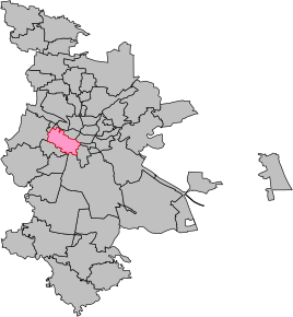
Location of the district 3425 Gostenhof in Nuremberg
|
|
Seeleinsbühl is the name for a former statistical district of Nuremberg . The name Seeleinsbühl has remained a term in Nuremberg.
Geographical location
Seeleinsbühl is in the west of Gostenhof , a district of Nuremberg . The district extended between Maximilianstrasse and Eberhardshof .
history
In 1898 Seeleinsbühl was incorporated into Nuremberg .
Churches
The Evangelical Lutheran community of Seeleinsbühl-Leyh includes the Epiphany Church and the Church of the Redeemer. The Epiphany Church on Maximilianstrasse was consecrated on September 27, 1970. Nearby, a little backwards, is a Romanian Orthodox church.
Infrastructure
Seeleinsbühl is mainly located on Fürther Strasse and Maximilianstrasse in Nuremberg . The Maximilianstrasse underground station is at the intersection of these two main roads. It belongs to the underground line 1 ( Fürth - Langwasser ). The area was shaped by the Quelle mail order company for many years; The Quelle company has been insolvent since 2009.
Web links
- Wiltrud Fischer-Pache: Seeleinsbühl . In: Michael Diefenbacher , Rudolf Endres (Hrsg.): Stadtlexikon Nürnberg . 2nd, improved edition. W. Tümmels Verlag, Nuremberg 2000, ISBN 3-921590-69-8 ( complete edition online ).


