St. Jobst
|
St. Jobst
Statistical District 90 City of Nuremberg
Coordinates: 49 ° 27 ′ 53 ″ N , 11 ° 7 ′ 8 ″ E
|
|
|---|---|
| Height : | 322–343 m above sea level NN |
| Area : | 1.83 km² |
| Residents : | 3986 (December 31, 2015) |
| Population density : | 2.175 inhabitants / km² |
| Incorporation : | 1899 |
| Postal code : | 90491 |
| Area code : | 0911 |
|
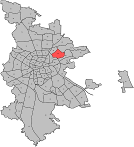
Location of the statistical district 90 St.Jobst
|
|
St. Jobst is a district of Nuremberg and the name of the statistical district 90 . The district belongs to the postal code district 90491. St. Jobst has belonged to Erlenstegen since 1813/18 and was incorporated into Nuremberg in 1899.
location
St. Jobst is in the east of Nuremberg on the Nuremberg-Hersbruck railway line or on the B14 (Äußere Sulzbacher Straße).
| Neighboring statistical districts | |||||||||
|---|---|---|---|---|---|---|---|---|---|
|
The small-scale division divides the area into the districts in a clockwise direction in the west
- 900 Weigelshof / Scharnhorststrasse. ,
- 901 St. Jobst (Bad Bernecker Str.),
- 903 St. Jobst (Steinplatte) ,
- 904 St. Jobst (Wöhrder See)
- 902 Rechenberg .
Parish
The street chapel of Jobst on the road to Prague was elevated to a place of pilgrimage in 1300 . Originally there was an infirmary on the site of the church , which was converted in 1525 into a preaching church dependent on the parish of St. Sebaldus . After the Prussian occupation of the suburbs of Nuremberg in 1796, the parish of St. Jobst was subordinated to the dean's office in Erlangen as an independent parish . In 1810 she came to the newly founded Bavarian Dean's Office in Nuremberg. The Evangelical Lutheran Church of St. Jobst today belongs to the Vice Dean of Nuremberg North. It is surrounded by a cemetery.
Rechenberg
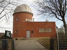
The Rechenberg is north of the Äußere Sulzbacher Straße. The Rechenberg Park, a park with playgrounds and the Regiomontanus observatory are located on it .
Manor houses in St. Jobst
In St. Jobst, the Weigelshof manor is located at Oedenberger Strasse 52, 54 and the Schübelsberg-Schlösslein at Bismarckstrasse 36.
Streets
|
|
literature
Wiltrud Fischer-Pache: St. Jobst . In: Michael Diefenbacher , Rudolf Endres (Hrsg.): Stadtlexikon Nürnberg . 2nd, improved edition. W. Tümmels Verlag, Nuremberg 2000, ISBN 3-921590-69-8 ( complete edition online ).
Web links
Individual evidence
- ^ City of Nuremberg, Office for Urban Research and Statistics for Nuremberg and Fürth (ed.): Statistical Yearbook of the City of Nuremberg 2016 . December 2015, ISSN 0944-1514 , 18 Statistical City Districts and Districts, p. 244–245 , p. 245 ( nuernberg.de [PDF; 6.3 MB ; accessed on November 1, 2017]).
- ^ City map service Nuremberg, District 90 St. Jobst


