Long water
|
Long water
City of Nuremberg
Coordinates: 49 ° 24 ′ 38 " N , 11 ° 7 ′ 43" E
|
|
|---|---|
| Height : | 329–339 m above sea level NN |
| Area : | 4.95 km² |
| Residents : | 31,033 (Dec. 31, 2005) |
| Population density : | 6,269 inhabitants / km² |
| Postcodes : | 90471, 90473 |
| Area code : | 0911 |
|
District 3440 Langwasser in Nuremberg
|
|
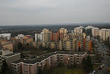
Langwasser is a district in the southeast of Nuremberg and the name of the district 3440. It is the prototype of a so-called satellite town . The name Langwasser comes from a small stream that runs through the area on the eastern edge.
geography
Langwasser is located southeast of the Nuremberg Exhibition Center between Münchner Strasse in the west and Gleiwitzer Strasse in the east. The northern border is a short stretch of Otto-Bärenreuther-Straße, starting from Münchner Straße, continuing along Karl-Schönleben-Straße to the northern end of Gleiwitzer-Straße.
| Neighboring statistical districts | |||||||||
|---|---|---|---|---|---|---|---|---|---|
|
Statistical districts
The district is divided into the following four districts.
- 33 - Langwasser northeast
- 36 - Langwasser southeast
- 37 - Langwasser southwest
- 32 - Langwasser northwest
Statistical Districts
The districts are divided into the following districts:
- 320 - Langwasser Northwest (Neuselsbrunn)
- 321 - Langwasser northwest (Hochvogelring)
- 322 - Langwasser Northwest (Wettersteinstrasse)
- 331 - Langwasser Northeast (Bertolt-Brecht-Str.)
- 332 - Langwasser Northeast ( Langwassersee )
- 333 - Langwasser Northeast (Hans-Fallada-Str.)
- 334 - Langwasser Northeast (Lina-Ammon-Str.)
- 360 - Langwasser Southeast (Lübener Str.)
- 361 - Langwasser Southeast (indoor swimming pool)
- 362 - Langwasser Southeast (Reinerzer Str.)
- 363 - Langwasser Southeast (Georg-Ledebour-Str.)
- 364 - Langwasser Southeast (Imbuschstr.)
- 365 - Langwasser Southeast (Frankenzentrum)
- 366 - Langwasser southeast (forest)
- 370 - Langwasser Südwest (heating plant)
- 371 - Langwasser Southwest (Glatzer Str.)
- 372 - Langwasser Southwest (Julius-Leber-Str.)
- 373 - Langwasser Southwest (Dr.-Linnert-Ring)
- 374 - Langwasser Southwest (Zollhaus-Str.)
- 375 - Langwasser Southwest (Am Zollhaus)
history
The area in the southeast of Nuremberg, known today as Langwasser, was densely forested at the beginning of the 20th century and belonged to the Lorenzer Reichswald , around 1910 the area was a restricted military area due to a shooting range . After devastating forest fires from 1917 to 1919, the area was cleared in the twenties and at times served agricultural purposes.
The time of the Nazi party rallies
During the time of the National Socialist party rallies , the cleared and practically unused area offered itself to the participants' mass camps. From 1934 onwards, the tent cities were set up here every September, and the little infrastructure was adapted to the new needs. For example, a railway station in Märzfeld , which was never completely finished and designed for several platforms and tracks, was laid out on the north-western edge of the tent city area. So the simple party congress participants who stayed overnight in the camp could easily arrive and depart. This station was used as a simple Langwasser stop until the end of the 1980s. The partially bricked up shell ruins of the station are still preserved today. The partly ingrown portal facade in a kind of neoclassical style, which is now hidden between the subway depot embankment and the railway embankment, reflects the spirit that prevailed at the time.
When after the start of the war in the first half of the 1940s there were no more party conventions on the site, the German Wehrmacht confiscated the site with the existing storage facilities originally built for visitors to the Nazi Party and rededicated it as a POW camp . Foreign prisoners of war were housed there in wooden barracks of the Reich Labor Service .
There, in April 1946, members of the Nakam group attempted to poison around 12,000 to 15,000 prisoners of war (mainly former SS members) who had been interned in the former (XIII D) main camp in Langwasser, which had been taken over by the Americans .
Post-war and modern times
The actual district history of Langwasser begins a few years after the Second World War . For ten years, parts of the site were a mixture of refugee camps , the first housing estates and remains of buildings from the Nazi party rallies. In the southwestern part of Langwasser, there was an associated foreigner and prisoner of war cemetery until its dissolution in 1958, of which there is a memorial plaque today.
The best known was the Valka camp , a kind of transitional camp for foreigners who were waiting for emigration or a new start in Germany. From 1954 to 1960, the Valka camp was the federal assembly camp for foreigners and thus the forerunner for the central contact point for asylum seekers (later in Zirndorf ) and the later Federal Office for the Recognition of Foreign Refugees (today: Federal Office for Migration and Refugees ) in Nuremberg. The first housing estates emerged around 1950. Many German expellees , especially from Silesia and the Sudetenland , found a new home in Langwasser.
The modern age of Langwasser began with the decision of the city of Nuremberg to develop coordinated development on the site under the motto "Living in the countryside". An architecture competition was concluded in 1956, and in 1957 the construction of the new district began in sections, the main features of which were not completed until the end of the 1990s. Larger parts of the settlement will be realized until the late 2010s.
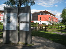
Also on the to Reichsparteitagsgelände associated Märzfeld , which was used after the war as US military training area, was begun in 1972, the North East Lang water. A fragment of the grandstand and an information board ( coordinates / ) are reminiscent of the March field .
architecture
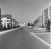
The first solid stone houses were built in the west of Langwasser in the first years after the Second World War, using funds from the Marshall Plan . The city of Nuremberg and its housing association WBG then announced an architectural competition in 1955 for a new town designed for 40,000 inhabitants.
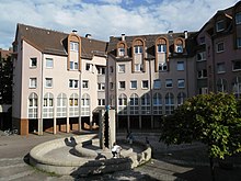
Franz Reichel won the competition as an architect together with the landscape planner Hermann Thiele . The basic structures of his design have been preserved to this day and were the model for many urban developments in the period that followed. One of the basic ideas was the development of residential areas only through side streets, green belts and supplying the population through shopping centers . Residential and commercial areas remained spatially separated, but the basic idea of “living and working” in the district was nevertheless realized thanks to the easy accessibility. The building architecture has always been subject to changing times, so that the modern development of German urban development can be traced quite well in the main building phase, which lasted around 40 years. Many of the developments were groundbreaking in their time of origin - examples are the regression from the flat roof (Langwasser-Süd) back to the gable roof (Langwasser-Nord-Ost) in multi-family houses, the district heating supply of the entire district with only one central small power plant for air pollution control or the Franconia -Center as one of the first completely covered shopping centers in Germany . Langwasser Nordost is designed in the area of the Euckenweg with car-free and partly covered footpaths to the subway; however, underground car parks are accessed from side streets. The ecumenical center St. Maximilian Kolbe has a strong impact on the townscape .
Arts and Culture
The Langwasser community center was built as a central facility for this purpose. In addition to a branch of the city library, a wide range of activities such as courses, theater performances, exhibitions, etc. is offered in this spacious event building. The Langwasser district forum has its office there. In the area of the district, various works of art from the different stages of development of the district are displayed. In addition to aluminum sculptures from the “Art in Urban Space” event ring from the early 1970s, the latest artistic achievement is a steel sculpture on the central Heinrich-Böll-Platz.
In the far south a house of homeland was built in memory of ethnic repatriates, displaced persons, etc. In the far north is Langwasser's largest school, the Bertolt Brecht School .
economy
Since the planning of the district provided for both residential and commercial areas from the outset, today there are commercial axes between the residential areas along the railway and main roads with numerous small and large commercial enterprises. As essential are u. a .:
- Bavarian Administration School (BVS)
- Eurocom Business Park ( Rudolf Wöhrl AG , Siemens , ABB, Sailer-Verlag, various personnel management, finance and IT service providers, environmental town hall, doctors and medical service providers)
- Franken Center
- Long water center
- Lebkuchen-Schmidt (Nuremberg oldest gingerbread - mail order company )
- Lebkuchen Schumann (closed in 2017 and production relocated to the Nordstadt plant, takeover of the Lambertz groups in 2015)
- noris network AG
- Prinovis print shop (location closed on April 30, 2021, Quelle catalog, IKEA catalog, formerly Maul & Belser )
- U-Bahn workshop (VAG Nuremberg)
- Central Tax Office Nuremberg
Churches
In the district there are four Evangelical Lutheran churches ( Martin-Niemöller-Kirche , Paul-Gerhardt-Kirche , Dietrich-Bonhoeffer-Kirche , Passionskirche ), four Catholic churches ( Incarnation of Christ , St. Maximilian Kolbe , Zum Guten Sheten , Heiligste Dreifaltigkeit) ) and two free churches ( Free Christian Community Langwasser eV , CMBG Nürnberg eV ).
traffic
Langwasser is connected via the B 8 to the A 73 (connection point Nürnberg-Zollhaus), via the B 4 to the A 9 (connection point Nürnberg-Fischbach) and the A 6 (connection point Nürnberg-Langwasser).
East of the district runs the Nuremberg-Regensburg railway , with Fischbach (b Nürnberg) and Nürnberg-Frankenstadium two breakpoints of the train has. From this railway line branches off the Ringbahn , which runs through the middle of Langwasser (in a west-east direction) and with Nürnberg-Langwasser had a stop that was served by passenger trains until 1988 . Today only freight trains from and to the Nuremberg marshalling yard run on the line .
The main access to local public transport to the center takes place with the underground line U1 , which starts in Langwasser Süd, traverses the district in a north-westerly direction and connects with the community center , Langwasser Mitte , Scharfreiterring and Langwasser Nord stations . At the station Langwasser center there is a bus station at the city bus lines in the neighborhoods Dutzendteich, Altenfurt , Fischbach and Katzwang depart, the station Langwasser Süd start or end the buses to Brunn and Birnthon .
The Omnibusverkehr Franken GmbH has its depot near the Langwasser Mitte in Breslauerstraße.
Landscape protection area Langwasser
The Langwasser landscape protection area is located in the south and at the Nuremberg South Clinic (LSG-00536.19, World Database on Protected Areas - Langwasser ). The 460.36 hectare area was designated in 2000.
literature
- History for All e. V. (Ed.): Langwasser - feel at home in Nuremberg's youngest district . ISBN 3-930699-30-3 .
- History for All e. V. (Hrsg.): Nürnberg-Langwasser, history of a district . ISBN 3-930699-05-2 .
Web links
- Medienwerkstatt Franken: Grüner Trabant Langwasser - a district portrait (video, running time: 28:57 minutes)
Individual evidence
- ^ A b c Office for Urban Research and Statistics: StA regional divisions Nuremberg. Accessed February 16, 2020 .
- ↑ Erika Sanden: The prisoner of war camp Langwasser as a research object . In: Contributions to political education . No. 3 . Pedagogical Institute, Nuremberg 1986.
- ↑ Alexander Osang, DER SPIEGEL: Revenge is mine - DER SPIEGEL - history. Accessed January 21, 2020 .
- ↑ [1] View of the "car-free" area in Google maps


