
Langwasser Nord underground station


The Langwasser Nord underground station (abbreviation: LN ) is the 5th underground station of the Nuremberg underground and was opened on March 1, 1972. It is 709 m from the Messe underground station and 547 m from the Scharfreiterring underground station and is served by the U1 line. The underground station is named after its location on the northern edge of the Langwasser district of Nuremberg . It is used by around 9,600 passengers every day.
location
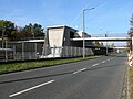
The station is located in the Nuremberg district Langwasser above ground in the midst of Otto Bärnreuther Street. A staircase leads from both platform heads to a pedestrian walkway and from there to the residential areas on both sides of Otto-Bärnreuther-Straße. The elevator connects the platform with the north-western pedestrian walkway.
The catchment area of the station includes the Bertolt-Brecht-Schule in the northeast and the district shopping center on Wettersteinstrasse to the southwest, each with the adjacent residential areas.
Building and architecture
The construction work for the 135 m long station building began in 1967. The north-west staircase and the elevator were added in 1983.
The platform was built in the style of the 1960s with exposed concrete , the platform roof is supported by ten supports.

East view

West view
Exterior view at street level

Access to the distribution bridge

Northwest staircase to the distributor bridge
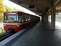
U1 to Fürth Hardhöhe

Sidings next door


Lines
| line | course |
|---|---|
|
|
Langwasser Süd - Community House - Langwasser Mitte - Scharfreiterring - Langwasser Nord - Messe - Bauernfeindstrasse - Hasenbuck - Frankenstrasse - Maffeiplatz - Aufseßplatz - Central Station - Lorenzkirche - White Tower - Plärrer - Gostenhof - Bärenschanze - Maximilianstrasse - Eberhardshof - Muggenhof - city limits - Jakobinenstrasse - Fürth Central Station - Fürth Rathaus - Fürth Stadthalle - Fuerth Hospital - Furth Hardhöhe |
The station is served by the U1 line. On weekends and before public holidays, the bus stop of the same name is also served by the N4 night bus.
literature
- City of Nuremberg / Building Department (Ed.): U-Bahn Nuremberg 3 . Press and Information Office of the City of Nuremberg, Nuremberg 1972.
- Michael Schedel: Nuremberg U-Bahn Album . Robert Schwandl Verlag, Berlin 2007, ISBN 3-936573-11-5 .
Web links
- Local area map on the sides of the VGN (PDF; 68.55 KB)
- Station pictures on cityverkehr.de (private)
Individual evidence
- ↑ Overview: These are the most used underground stations in Nuremberg on nordbayern.de, from December 27, 2019, accessed on January 6, 2020
| Previous station | Nuremberg subway | Next station |
|---|---|---|
|
Fair ← Fürth Hardhöhe |
|
Scharfreiterring Langwasser Süd → |
Coordinates: 49 ° 24 ′ 44 ″ N , 11 ° 7 ′ 18 ″ E

Lines :
![]() |
|
![]() |
|
![]() • Former lines :
• Former lines :
![]() |
|
![]()
Vehicles : type DT1 | Type DT2 | Type DT3 / DT3-F | Type A | Type G1
Railway stations : Aufseßplatz | Bauernfeindstrasse | Bärenschanze | Eberhardshof | Airport | Frankenstrasse | Friedrich-Ebert-Platz | Fürth Hardhöhe | Fürth Central Station | Fürth Clinic | Fürth town hall | Fürth City Hall | Community house | Gostenhof | Großreuth near Schweinau | Gustav-Adolf-Strasse | Hasenbuck | Central station | Herrnhütte | High torture | Jakobinenstrasse | Kaulbachplatz | North Hospital | Langwasser middle | Langwasser North | Langwasser South | Lorenz Church | Maffeiplatz | Maxfeld | Maximilianstrasse | Fair | Muggenhof | Northeast Station | Northwest Ring | Opera House | Blusterer | Rathenauplatz | Rennweg | Röthenbach | Rothenburger Strasse | Scharfreiterring | Schoppershof | Schweinau | St. Leonhard | City limits | Sündersbühl | White Tower | Wöhrder Wiese | Brick