
Wöhrder Wiese underground station


The Wöhrder Wiese underground station (abbreviation: WW ) is the 30th underground station of the Nuremberg underground and was opened on September 29, 1990. It is 767 m from the Hauptbahnhof underground station and 525 m from Rathenauplatz underground station . An x-shaped double track change connects to the station in the direction of Röthenbach. The Wöhrder Wiese is a park-like green area between Lake Wöhrder and the eastern edge of Nuremberg's old town. It is named after the Nuremberg district of Wöhrd , which was incorporated in 1825 . It is used by around 17,200 passengers every day.
location
The train station is located in the Nuremberg district of Gleißbühl and extends underground in a south-north direction east of the Franz-Josef-Strauss Bridge between Pegnitz and Prinzregentenufer. From the southern head of the platform, a staircase leads directly to Wöhrder Wiese , the northern station staircase leads to a distribution floor and from there to Wöhrder Wiese, Prinzregentenufer and Laufertorgraben. An elevator takes you from the center of the station to the peninsula between Pegnitz, Nonnenbach and Franz-Josef-Strauss-Brücke.
The Cinecittà , the Natural History Society , the Georg-Simon-Ohm University , the Insel Schütt and the Wöhrder Wiese are in the vicinity of the train station .
Building and architecture
The station structure is 147 m long, 17.5 m wide and 15 m deep (one and a half times the depth). The construction work for the station began on April 1, 1987 and was carried out using the cut-and-cover method with back-anchored sheet piling . During the construction work, the Nonnenbach and the Pegnitz were guided over the excavation pit with trough bridges, the northern arm of the Pegnitz was visibly integrated into the building ceiling and incorporated into the station design. Due to its proximity to the Pegnitz, the south exit is provided with flood protection devices (rails in the walls into which panels can be embedded).
The architectural design was carried out by the Nuremberg designers Stefan Maier and Bernhard Lugert. The green circles on the platform walls symbolize the Wöhrder Wiese and the blue circles on the wall and ceiling indicate the Pegnitz crossing in the middle of the building. The remaining walls and the ceiling are covered with coarse-pored shotcrete.

Departure at the Wöhrder meadow

View from the south exit of the platform level

View into the southern entrance building

Northern exit to the platform level

Escalators to the south entrance
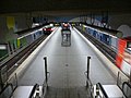
Platform level overview
.jpg)


Lines
| line | course |
|---|---|
|
|
Röthenbach - Hohe Marter - Schweinau - St. Leonhard - Rothenburger Straße - Plärrer - Opera House - Central Station - Wöhrder Wiese - Rathenauplatz - Rennweg - Schoppershof - Nordostbahnhof - Herrnhütte - Ziegelstein - Airport |
|
|
Gustav-Adolf-Straße - Sündersbühl - Rothenburger Straße - Plärrer - Opera House - Central Station - Wöhrder Wiese - Rathenauplatz - Maxfeld - Kaulbachplatz - Friedrich-Ebert-Platz - Klinikum Nord - Nordwestring |
- Transfer options
| line | route | Clock frequency |
|---|---|---|
|
|
Documentation Center - Luitpoldhain - Meistersingerhalle - Place of the Victims of Fascism - Holzgartenstrasse - Wodanstrasse - Schweiggerstrasse - Scheurlstrasse - Marientunnel - Central Station - Marientor - Wöhrder Wiese - Rathenauplatz - Stresemannplatz - Deichslerstrasse - Tauroggenstrasse - Tafelhalle - Ostbahnhof - Thumenberger Erlenstegen - Platnersberg - | 10 min |
The night bus routes N1 , N11 , N12 and N13 also operate on weekends and before public holidays .
literature
- City of Nuremberg / Building Department (Ed.): U-Bahn Nuremberg 12 . Press and Information Office of the City of Nuremberg, Nuremberg 1990.
- Michael Schedel: Nuremberg U-Bahn Album . Robert Schwandl Verlag, Berlin 2007, ISBN 3-936573-11-5 .
Web links
- Local area map on the sides of the VGN (PDF; 84.84 KB)
- Station description on local traffic Franconia
- Station pictures on cityverkehr.de
Individual evidence
- ↑ Overview: These are the most used underground stations in Nuremberg on nordbayern.de, from December 27, 2019, accessed on January 6, 2020
Coordinates: 49 ° 27 ′ 9 ″ N , 11 ° 5 ′ 13 ″ E

Lines :
![]() |
|
![]() |
|
![]() • Former lines :
• Former lines :
![]() |
|
![]()
Vehicles : type DT1 | Type DT2 | Type DT3 / DT3-F | Type A | Type G1
Railway stations : Aufseßplatz | Bauernfeindstrasse | Bärenschanze | Eberhardshof | Airport | Frankenstrasse | Friedrich-Ebert-Platz | Fürth Hardhöhe | Fürth Central Station | Fürth Clinic | Fürth town hall | Fürth City Hall | Community house | Gostenhof | Großreuth near Schweinau | Gustav-Adolf-Strasse | Hasenbuck | Central station | Herrnhütte | High torture | Jakobinenstrasse | Kaulbachplatz | North Hospital | Langwasser middle | Langwasser North | Langwasser South | Lorenz Church | Maffeiplatz | Maxfeld | Maximilianstrasse | Fair | Muggenhof | Northeast Station | Northwest Ring | Opera House | Blusterer | Rathenauplatz | Rennweg | Röthenbach | Rothenburger Strasse | Scharfreiterring | Schoppershof | Schweinau | St. Leonhard | City limits | Sündersbühl | White Tower | Wöhrder Wiese | Brick