
Opera House underground station


The Opernhaus underground station (abbreviation: OP ) is the 29th underground station on the Nuremberg underground and was opened on September 24, 1988. It is served by the U2 and U3 lines and is 753.5 m from Plärrer underground station and 533 m from Hauptbahnhof underground station . At the station there is a double track change in the direction of Röthenbach . Today's opera house was built in 1905 on the site of the old city hospital as the new city theater . In 1930 it was renamed the Opera House and has been the Bavarian State Theater since 2003. It is used by around 14,900 passengers every day.
location
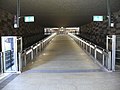
The station is located in the Tafelhof district of Nuremberg and extends underground in a west-east direction under the Frauentorgraben between Weidenkellerstraße and Richard-Wagner-Platz. Ramps lead from the two platform heads to a distribution floor and from there into the city moat as well as into Weidenkellerstraße and Richard-Wagner-Platz. A third exit is located in the center of the station and spans the northern platform track and the city moat by means of a bridge and leads to the Carthusian Gate and the Frauentorgraben. It includes an elevator from the platform to the transition and from the transition to the Carthusian Gate.
The main office of the Employment Agency , the Germanisches Nationalmuseum , the Staatstheater Nürnberg , the Straße der Menschenrechte and the Transport Museum are located in the vicinity of the train station .
Building and architecture
The station structure is 219 m long, 15 m wide and 10 m deep (one and a half times the depth). The construction work for the station began on March 10, 1986 and was carried out in the open construction method with Berlin shoring . In the course of the construction work, the moat from the Färbertor to the Frauentor, which was filled in in the 1960s to widen the street “Frauentorgraben”, was uncovered again.
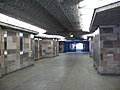
Architecturally, the station is influenced by the opera house and the city wall and, for a better overview, has no supports. A grille designed by the artist Hans Karl Busch separates the platform area from the moat. The spheres attached to the grid, which rotate in the wind of the incoming and outgoing trains, symbolize the Behaim globe . The nine openings in the northern platform wall facing the moat are modeled on the relief arches of the moat wall and clad with sandstones. The platform wall to the opera house is also clad with sandstone and interrupted by niches in which cast iron replicas of the opera house silhouette by Theo Kief are attached. The building ceiling is designed as barrel and cross vaults and clad with coarse-pored concrete and sandstone.

Exit in front of the opera house

Station name on the platform walls

Access in the city moat
Distribution level at the entrance from the city moat
Ramp to the distribution floor

Medium access by bridge over the moat
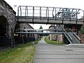
View of the bridge construction from the city moat

Platform level with underground train of type DT3


Lines
| line | course |
|---|---|
|
|
Röthenbach - Hohe Marter - Schweinau - St. Leonhard - Rothenburger Straße - Plärrer - Opera House - Central Station - Wöhrder Wiese - Rathenauplatz - Rennweg - Schoppershof - Nordostbahnhof - Herrnhütte - Ziegelstein - Airport |
|
|
Gustav-Adolf-Straße - Sündersbühl - Rothenburger Straße - Plärrer - Opera House - Central Station - Wöhrder Wiese - Rathenauplatz - Maxfeld - Kaulbachplatz - Friedrich-Ebert-Platz - Klinikum Nord - Nordwestring |
The station is served by the U2 and U3 lines. The night bus routes N6 , N7 , N9 and N10 also operate on weekends and before public holidays .
literature
- City of Nuremberg / Building Department (Ed.): U-Bahn Nuremberg 11 . Press and Information Office of the City of Nuremberg, Nuremberg 1988.
- Michael Schedel: Nuremberg U-Bahn Album . Robert Schwandl Verlag, Berlin 2007, ISBN 3-936573-11-5 .
Web links
- Local area map on the sides of the VGN (PDF; 59.13 KB)
- Station description on local traffic Franconia (private)
- Station pictures on cityverkehr.de (private)
- [1] Video of an incoming subway
Individual evidence
- ↑ Overview: These are the most used underground stations in Nuremberg on nordbayern.de, from December 27, 2019, accessed on January 6, 2020
Coordinates: 49 ° 26 ′ 48 " N , 11 ° 4 ′ 30" E

Lines :
![]() |
|
![]() |
|
![]() • Former lines :
• Former lines :
![]() |
|
![]()
Vehicles : type DT1 | Type DT2 | Type DT3 / DT3-F | Type A | Type G1
Railway stations : Aufseßplatz | Bauernfeindstrasse | Bärenschanze | Eberhardshof | Airport | Frankenstrasse | Friedrich-Ebert-Platz | Fürth Hardhöhe | Fürth Central Station | Fürth Clinic | Fürth town hall | Fürth City Hall | Community house | Gostenhof | Großreuth near Schweinau | Gustav-Adolf-Strasse | Hasenbuck | Central station | Herrnhütte | High torture | Jakobinenstrasse | Kaulbachplatz | North Hospital | Langwasser middle | Langwasser North | Langwasser South | Lorenz Church | Maffeiplatz | Maxfeld | Maximilianstrasse | Fair | Muggenhof | Northeast Station | Northwest Ring | Opera House | Blusterer | Rathenauplatz | Rennweg | Röthenbach | Rothenburger Strasse | Scharfreiterring | Schoppershof | Schweinau | St. Leonhard | City limits | Sündersbühl | White Tower | Wöhrder Wiese | Brick