
Langwasser Mitte underground station


The Langwasser Mitte underground station (abbreviation: LM ) was opened as the third underground station on the Nuremberg underground on March 1, 1972. It is 591 m from the Scharfreiterring underground station and 494 m from the Gemeinschaftshaus underground station . In the original plans, this underground station had the working title Breslauer Straße . Its current name goes back to its location in the center of the Langwasser district of Nuremberg . It is used by around 18,500 passengers every day.
location
The station is located in the Nuremberg district Langwasser and extends underground in northwest-southeast alignment between the crossing Otto-Bärnreuther- / Breslauer Street and the bus station . The north entrance leads to Breslauer Strasse, the south entrance to the bus station. The elevator goes from the center of the platform to the surface north of the bus station.
The Franken-Center is located in the immediate vicinity of the train station .
Building and architecture
Construction work on the station building began in 1967 and was carried out using the cut-and-cover method. The elevator was retrofitted in 1982.
The design of the station as a functional building corresponds to the style of the 1960s. The platform walls, tiled with ceramic tiles, are gray from the floor to the level of the platform edge and then white to the ceiling, only the strip with the stop name is light brown with white lettering. The square ceiling supports are also tiled in white.
The bus station is spanned by a massive concrete roof and was built when the subway was built. However, it only went into full operation on January 28, 1978 when the U-Bahn was extended to Nuremberg's old town.
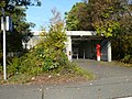
Northern access

South access (at the bus station)

Ascent from the platform level to the surface
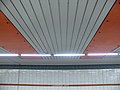
Ceiling design
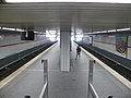
Overview of the platform level


Lines

| line | course |
|---|---|
|
|
Langwasser Süd - Community House - Langwasser Mitte - Scharfreiterring - Langwasser Nord - Messe - Bauernfeindstrasse - Hasenbuck - Frankenstrasse - Maffeiplatz - Aufseßplatz - Central Station - Lorenzkirche - White Tower - Plärrer - Gostenhof - Bärenschanze - Maximilianstrasse - Eberhardshof - Muggenhof - city limits - Jakobinenstrasse - Fürth Central Station - Fürth Rathaus - Fürth Stadthalle - Fuerth Hospital - Furth Hardhöhe |
The station is served by the U1 line (Langwasser Süd - Fürth Hardhöhe). On the surface there is a bus station where the city bus routes 50 (Langwasser Mitte - Feucht Am Reichswald), 52 (Langwasser Mitte - Katzwang Süd), 55 (Langwasser Mitte - Meistersingerhalle), 56 (Langwasser Mitte - Flachröste), 57 (Langwasser Mitte - Fischbach Bahnhof Wende), 68 (Langwasser Mitte - Gustav-Adolf-Straße), 92 (Meistersingerhalle - Katzwang Süd), 93 (Meistersingerhalle - Kornburg) and 98 (Langwasser Mitte - Stein Schloß) as well as the OVF lines 602 (Langwasser Mitte - Kleinschwarzenlohe), 603 (Langwasser Mitte - Raubersried) and 610 (Langwasser Mitte - Wendelstein - Langwasser Mitte). On weekends the night bus routes N4 (Hauptbahnhof - Brunn) and N60 (Langwasser Mitte - Kornburg) also run at night .
literature
- City of Nuremberg / Building Department (Ed.): U-Bahn Nuremberg 3 . Press and Information Office of the City of Nuremberg, Nuremberg 1972.
- Michael Schedel: Nuremberg U-Bahn Album . Robert Schwandl Verlag, Berlin 2007, ISBN 3-936573-11-5 .
Web links
- Area map on the VGN website (PDF; 226 KB)
Individual evidence
- ↑ Overview: These are the most used underground stations in Nuremberg on nordbayern.de, from December 27, 2019, accessed on January 6, 2020
| Previous station | Nuremberg subway | Next station |
|---|---|---|
|
Scharfreiterring ← Fürth Hardhöhe |
|
Community house Langwasser Süd → |
Coordinates: 49 ° 24 '17 " N , 11 ° 7' 55" E

Lines :
![]() |
|
![]() |
|
![]() • Former lines :
• Former lines :
![]() |
|
![]()
Vehicles : type DT1 | Type DT2 | Type DT3 / DT3-F | Type A | Type G1
Railway stations : Aufseßplatz | Bauernfeindstrasse | Bärenschanze | Eberhardshof | Airport | Frankenstrasse | Friedrich-Ebert-Platz | Fürth Hardhöhe | Fürth Central Station | Fürth Clinic | Fürth town hall | Fürth City Hall | Community house | Gostenhof | Großreuth near Schweinau | Gustav-Adolf-Strasse | Hasenbuck | Central station | Herrnhütte | High torture | Jakobinenstrasse | Kaulbachplatz | North Hospital | Langwasser middle | Langwasser North | Langwasser South | Lorenz Church | Maffeiplatz | Maxfeld | Maximilianstrasse | Fair | Muggenhof | Northeast Station | Northwest Ring | Opera House | Blusterer | Rathenauplatz | Rennweg | Röthenbach | Rothenburger Strasse | Scharfreiterring | Schoppershof | Schweinau | St. Leonhard | City limits | Sündersbühl | White Tower | Wöhrder Wiese | Brick