
Friedrich-Ebert-Platz underground station


The underground station Friedrich-Ebert-Platz (short name of the operator : FE ) is a station of the Nuremberg underground and was opened on December 10, 2011. It is 553 meters from the Kaulbachplatz underground station and 534 meters from the Klinikum Nord underground station and is served by the U3 line. It is used by around 13,200 passengers every day.
The square on Bucher Strasse was named after the first president of the Weimar Republic and SPD chairman Friedrich Ebert in 1954 .
location
The station is on the border of the Nuremberg districts of St. Johannis and Gardens behind the fortress and extends underground in an approximately east-west direction under Friedrich-Ebert-Platz . From the western head of the platform, an exit leads to the fork in Rückertstraße and Kirchenweg. From the eastern head of the platform, the exit leads to a distribution floor and from there to the east and west side of Bucher Strasse and the tram stop island. There is also an elevator from the platform level to the station island.
Building
The construction work for the 142-meter-long and ten-meter-deep station structure began in June 2007 and was carried out using the open construction method with Berlin sheeting and subsequent roofing . For the underpass of the station by a planned subway or light rail route, there were structural preliminary work.
The Nuremberg architecture office stm Architekten was responsible for the architectural design of the station together with the Nuremberg artist Peter Kampehl. The station is kept in warm red tones and is dominated by two murals by Peter Kampehl on the platform level. Also because this underground station is designed for the long term as a transfer station, it will be built in white and orange , as is usual in Nuremberg (see also Aufseßplatz underground station ).

Ascent from the platform level to the surface

Ascent from the platform level to the distribution floor

Distribution floor

View of the platform level
Access from the bus stop island


Lines
| line | course |
|---|---|
|
|
Gustav-Adolf-Straße - Sündersbühl - Rothenburger Straße - Plärrer - Opera House - Central Station - Wöhrder Wiese - Rathenauplatz - Maxfeld - Kaulbachplatz - Friedrich-Ebert-Platz - Klinikum Nord - Nordwestring |
The station has been served by the U3 line since its completion.
- Transfer options
| line | route | Clock frequency |
|---|---|---|
|
|
Gibitzenhof - Dianaplatz - Alemannenstraße - Brehmstraße - Landgrabenstraße - Steinbühl - Kohlenhof - Plärrer - Obere Turnstraße - Hallertor - Tiergärtnertor - Friedrich-Ebert-Platz - Juvenellstraße - Bucher Straße / Nordring - Thon - Cuxhavener Straße - Schleswiger Straße - Bamberger Straße - Am Wegfeld | 5/10 min |
The northern terminus of city bus 34 is at the confluence with Rückertstrasse . On weekends, the N10 night bus also runs here .
Design and criticism
surface

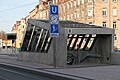
Although it is an important part of the city square, the city administration did not take the usual route of having an architects' competition search for the best solution, but awarded direct planning contracts. The surface design of the square is based on a design by the Nuremberg landscape architecture office Adler and Olesch. The shape of the superstructure of the underground station on the surface of the square was designed by the architectural office Stößlein, the location was already determined by the design of the underground construction office of the city of Nuremberg in advance of its architectural design. The access structures are criticized as "bulky" by the Nürnberger Nachrichten , among others . After several changes to the plan aimed at integrating the A1 staircase into the urban development, the architects of the station stated in a report for the meeting of the building and awarding committee of the city of Nuremberg on October 18, 2005 that the A1 staircase on Kirchenweg was “aware in front of the Art Nouveau facade ”, whereby the glass-concrete construction now enables“ a view from Friedrich-Ebert-Platz to the facade behind ”due to its transparency. In their description of the design, the architects state that "the shape of the staircase, due to the previously determined and urban-planning difficult location of the staircase (orientation and proximity to the surroundings)" deliberately aims at "that the staircase as an object emerging from the ground, is perceived. "
After the plan change described by Michael Stößlein on June 16, 2005, the Baukunstbeirat, an independent body of architects that advises the city council, stated in a second statement that the “staircase structure [...] is now in its 'object-like' transparent and The shape with reduced volume in interaction with the facade behind it "appears more pleasant.
These plans were confirmed in the meeting of the urban planning committee on April 2, 2009, but against the votes of the six representatives of the CSU city council faction in the committee, who refused to accept the loss of 13 parking spaces. The construction department justified the discontinuation of the parking spaces mainly with otherwise insufficient installation space for the fire brigade and an improvement in the quality of the space.
Following the meeting of the urban planning committee on April 2, 2009, the design of the square, in particular the number of car parking spaces that will be available in the future, was taken up in the local press and a negative public opinion was discussed, although the construction work to restore the Friedrich-Ebert- Square after the subway construction had not yet been completed. In the reporting, in particular, the rejection of parliamentary group members from several parties represented in the city council who, as members of various committees, were directly involved in the political decision-making process outlined here. In his address at the opening of the Maxfeld - Friedrich-Ebert-Platz section of the U 3, Lord Mayor Dr. Maly the surface design as “not exactly worthy of an architecture award”.
Elevator
Due to the design of the underground construction office of the city of Nuremberg, the elevator is located exactly at the interface between the platform of the underground line U3 and the waiting area in front of the tram stop of line 4 and thus connects the two stops of public transport in the shortest possible way .
The building department responded to criticism of the dangerous arrangement of the traffic light-secured pedestrian crossing from the new tram island to the west across Bucher Strasse. The pedestrians on the crossing could not see the street because of the elevator shaft; nor could they be seen by the approaching motorists.
Web links
- Information on the construction of the station on the website of the Nuremberg Building Department
- The design of the station on the website of the architectural office Stößlein Architekten
Individual evidence
- ↑ Online information from VAG ( page can no longer be accessed , search in web archives ) Info: The link was automatically marked as defective. Please check the link according to the instructions and then remove this notice. , accessed January 22, 2012
- ↑ Overview: These are the most used underground stations in Nuremberg on nordbayern.de, from December 27, 2019, accessed on January 6, 2020
- ^ City of Nuremberg, Civil Engineering Office / U-Bahnbau (Ed.): Construction time plan U3, BA 1.3 . Nuremberg March 2008 ( PDF, 61 KB ).
- ^ City of Nuremberg, Civil Engineering Office / U-Bahnbau (Ed.): U3 BA 1.3 Construction process . Residential information. Nuremberg April 2007 ( PDF, 1.4 MB ).
- ^ A b Prof. Michael Stößlein: Explanation of the design. (PDF) Spatial expansion of the Friedrich-Ebert-Platz underground station. In: Information from city council and committees. September 21, 2005, pp. 2–3 , accessed on September 30, 2011 (Appendix 5.1 to item 5 of the agenda of the meeting of the building and awarding committee on October 18, 2005): "Access A1 in front of the listed building [...]"
- ↑ VGN website ( page no longer available , search in web archives ) Info: The link was automatically marked as defective. Please check the link according to the instructions and then remove this notice. , accessed March 27, 2013
- ^ NN Online, accessed on January 2, 2012 [1]
- ↑ Architectural Advisory Board (BKB). (No longer available online.) Building Department of the City of Nuremberg, archived from the original on November 4, 2011 ; Retrieved September 30, 2011 . Info: The archive link was inserted automatically and has not yet been checked. Please check the original and archive link according to the instructions and then remove this notice.
- ↑ Minutes of the BKB from March 17, 2005 and June 16, 2005. (PDF) In: Information from city council and committees. Architecture Advisory Board of the City of Nuremberg, June 16, 2005, p. 2 , accessed on September 30, 2011 (Appendix 5.2 to item 5 of the agenda of the meeting of the building and awarding committee on October 18, 2005).
- ↑ Surface design at Friedrich-Ebert-Platz. (PDF) Decision. In: Information from city council and committees. April 2, 2009, accessed on September 30, 2011 (resolution on item 5 of the agenda of the meeting of the Urban Planning Committee on April 2, 2009).
- ↑ Surface design Friedrich-Ebert-Platz, application of the CSU city council group of April 2nd, 2009 (presented orally). (PDF) Decision. In: Information from city council and committees. April 2, 2009, accessed on September 30, 2011 (resolution on item 5 of the agenda of the meeting of the Urban Planning Committee on April 2, 2009).
- ↑ Presentation of the facts. (PDF) In: Information from city council and committees. April 2, 2009, pp. 2–3 , accessed on September 30, 2011 (Appendix 5.3 to item 5 of the agenda of the meeting of the Urban Planning Committee on April 2, 2009): “However, this meant that the installation space for the fire brigade was insufficient . Therefore the planning had to be revised in this regard. [...] This is considered to be justifiable in view of the excellent public development and the improvement in the quality of the space. The installation areas for the fire brigade and the ability to be guided to the building are guaranteed. "
- ^ Stadtanzeiger Nürnberg, April 16, 2009; ibid, April 20, 2011
- ↑ Committees and commissions. Retrieved on September 30, 2011 (with a link to an up-to-date list of “occupation of the city council committees”).
- ↑ Jo Seuss: The source of danger is defused. The building department wants to quickly eliminate visibility problems at Friedrich-Ebert-Platz. In: Nürnberger Stadtanzeiger. March 18, 2011, accessed September 19, 2011 .
- ↑ template. (PDF) In: Information from city council and committees. April 14, 2011, accessed on September 30, 2011 (report from the building consultant on item 6 of the agenda of the meeting of the transport committee on April 14, 2011): “The roadway in the direction of Bucher Strasse in the pedestrian area has a total width of 7.35 m. A dimensioning of 7.0 m is possible. The right-hand lane is 4.0 m wide, so that cyclists can still be overtaken by passenger cars. By shifting the curb line by 0.35 m to the west, an improvement in the visual relationships can be achieved. The distance between the curb and the subway structure is then 85 cm. [...] The administration is expanding the footprints for pedestrians. Traffic safety at Friedrich-Ebert-Platz will be significantly improved. "
- ↑ Surface design plan No. 2.1790.2.2. (PDF) In: Information from city council and committees. April 2, 2009, accessed on September 30, 2011 (Appendix 5.2 to item 5 of the agenda of the meeting of the Urban Planning Committee on April 2, 2009; note in particular sections A - A and B - B).
| Previous station | Nuremberg subway | Next station |
|---|---|---|
|
Kaulbachplatz ← Gustav-Adolf-Strasse |
|
Klinikum Nord Nordwestring → |

Lines :
![]() |
|
![]() |
|
![]() • Former lines :
• Former lines :
![]() |
|
![]()
Vehicles : type DT1 | Type DT2 | Type DT3 / DT3-F | Type A | Type G1
Railway stations : Aufseßplatz | Bauernfeindstrasse | Bärenschanze | Eberhardshof | Airport | Frankenstrasse | Friedrich-Ebert-Platz | Fürth Hardhöhe | Fürth Central Station | Fürth Clinic | Fürth town hall | Fürth City Hall | Community house | Gostenhof | Großreuth near Schweinau | Gustav-Adolf-Strasse | Hasenbuck | Central station | Herrnhütte | High torture | Jakobinenstrasse | Kaulbachplatz | North Hospital | Langwasser middle | Langwasser North | Langwasser South | Lorenz Church | Maffeiplatz | Maxfeld | Maximilianstrasse | Fair | Muggenhof | Northeast Station | Northwest Ring | Opera House | Blusterer | Rathenauplatz | Rennweg | Röthenbach | Rothenburger Strasse | Scharfreiterring | Schoppershof | Schweinau | St. Leonhard | City limits | Sündersbühl | White Tower | Wöhrder Wiese | Brick
Coordinates: 49 ° 27 ′ 45 ″ N , 11 ° 4 ′ 16 ″ E