
Fürth Rathaus underground station


The Fürth Rathaus subway station (abbreviation: RF ) is the 36th subway station of the Nuremberg subway and was opened on December 5, 1998. It is 636 m from the Fürth Stadthalle underground station and 889 m from the Fürth Hauptbahnhof underground station . At the train station, in the direction of Hardhöhe, there is a point- to-point change of platform. The underground station is named after the town hall of Fürth , under which it is located. It is used by around 18,300 passengers every day.
location
The train station is located in the inner city district of Fürth and extends underground in an east-west orientation in a left curve under Ludwig-Erhard-Straße between the coal market and the fruit market. From the eastern head of the station, an exit leads to a distribution floor under the coal market and from there to the Brandenburger and Ludwig-Erhard-Strasse and the coal market. From the western head of the station, an exit leads to a distribution floor below the fruit market and from there to Mohrenstrasse, the fruit market and the bus station. Two elevators lead to the surface from the east and west head of the platform.
In the vicinity of the train station are Gustavstraße , the Heinrich-Schliemann-Gymnasium , the Jewish Museum Fürth , the Art Gallery Fürth , the town hall with the Kriminalmuseum Fürth and the city theater .
Building and architecture
The station structure is 126 m long. The construction work for the station began in June 1996 and was carried out using the new Austrian tunnel construction method. In the course of the construction work, two buildings, u. a. the Café Fürst, to be demolished. The station itself consists of two individual tubes, which are connected by three cross passages and the two platform heads.
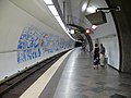
The architectural design was carried out according to a design by Tanja Bürgelin-Arslan, the winner of the design competition announced by the Georg-Simon-Ohm University of Nuremberg . The platform hall resembles the Lorenzkirche underground station in terms of its appearance in the form of a grotto , but appears friendlier and more modern thanks to the use of stainless steel and lighting elements. 5 × 60 m panoramas of Fürth city center are attached to both platform walls. Important buildings are highlighted in it and are explained by display boards placed in the cross passages. In order to facilitate orientation in the distribution floors and the stairways, the buildings opposite the stairway are shown on the corridor walls.

Entrance to the underground station
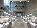
Exit from the distribution floor to the platform level
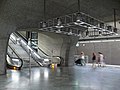
Ascent from the platform to the distribution floor

Information boards in the cross passages

Station name on the platform wall
Tube towards Fürth Hardhöhe
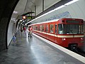
U1 to Langwasser-Süd


Lines
| line | course |
|---|---|
|
|
Langwasser Süd - Community House - Langwasser Mitte - Scharfreiterring - Langwasser Nord - Messe - Bauernfeindstrasse - Hasenbuck - Frankenstrasse - Maffeiplatz - Aufseßplatz - Central Station - Lorenzkirche - White Tower - Plärrer - Gostenhof - Bärenschanze - Maximilianstrasse - Eberhardshof - Muggenhof - city limits - Jakobinenstrasse - Fürth Central Station - Fürth Rathaus - Fürth Stadthalle - Fuerth Hospital - Furth Hardhöhe |
The station is served by the U1 line. On the surface there is a bus station with the possibility to change to the Nuremberg city bus routes 33 and 39 , the Fürth city bus routes 173 to 175 and 177 to 179 as well as the OVF lines 125 and 126 . The night bus routes N9 , N17 , N18 , N21 , and N22 also operate at night on weekends, before public holidays and on bridging days .
literature
- City of Fürth (Ed.): U-Bahn Fürth, construction phase 2 . Mayor and press office of the city of Fürth, Fürth 1998.
- Michael Schedel: Nuremberg U-Bahn Album . Robert Schwandl Verlag, Berlin 2007, ISBN 978-3-936573-11-4 .
Web links
- Local area map on the sides of the VGN (PDF; 135.58 KB)
- Station description on local traffic Franconia (private)
- Station pictures on cityverkehr.de (private)
Individual evidence
- ↑ Overview: These are the most used underground stations in Nuremberg on nordbayern.de, from December 27, 2019, accessed on January 6, 2020
| Previous station | Nuremberg subway | Next station |
|---|---|---|
|
Fürth Stadthalle ← Fürth Hardhöhe |
|
Fürth main station Langwasser Süd → |
Coordinates: 49 ° 28 ′ 38 ″ N , 10 ° 59 ′ 19 ″ E

Lines :
![]() |
|
![]() |
|
![]() • Former lines :
• Former lines :
![]() |
|
![]()
Vehicles : type DT1 | Type DT2 | Type DT3 / DT3-F | Type A | Type G1
Railway stations : Aufseßplatz | Bauernfeindstrasse | Bärenschanze | Eberhardshof | Airport | Frankenstrasse | Friedrich-Ebert-Platz | Fürth Hardhöhe | Fürth Central Station | Fürth Clinic | Fürth town hall | Fürth City Hall | Community house | Gostenhof | Großreuth near Schweinau | Gustav-Adolf-Strasse | Hasenbuck | Central station | Herrnhütte | High torture | Jakobinenstrasse | Kaulbachplatz | North Hospital | Langwasser middle | Langwasser North | Langwasser South | Lorenz Church | Maffeiplatz | Maxfeld | Maximilianstrasse | Fair | Muggenhof | Northeast Station | Northwest Ring | Opera House | Blusterer | Rathenauplatz | Rennweg | Röthenbach | Rothenburger Strasse | Scharfreiterring | Schoppershof | Schweinau | St. Leonhard | City limits | Sündersbühl | White Tower | Wöhrder Wiese | Brick