
Muggenhof underground station


The Metro Station Muggenhof (abbreviation: MU ) is the 20th subway station of Nuremberg subway and from the line U1 served. It is 953 m away from the city limits underground station and 858 m from the Eberhardshof underground station . At the station, in the direction of Langwasser, there is a platform change with a sharp point and then a parking and sweeping system to the Eberhardshof station. The underground station is named after the Muggenhof district of Nuremberg, which was incorporated in 1899 and in which it is located. It is used by around 7,500 passengers every day.
history
The station is part of the elevated railway in Fürther Straße , which was built between September 6, 1967 and autumn 1970 in connection with the construction of the Frankenschnellweg . On November 4, 1970, the station was first opened to the tram and served by it until June 20, 1981. Because of the tram operation, it has two side platforms. This was followed by the approx. One year renovation phase in order to bring the structure and the stations up to underground standards; u. a. the platforms were brought to 1 m above the top of the rails and elevators were retrofitted. On March 20, 1982, the station was opened for the underground. In the summer of 2000, the elevated railway was renovated and the station was given a new look.
location
The station is located in the Muggenhof district of Nuremberg and extends in an elevated position in an east-west direction over the intersection of Fürther- / Adolf-Braun- / Sigmundstraße between Fuchs- and Tassilostraße. From both platform heads exits lead to a distribution floor and from there two stairways each to the north and south side of Fürther Straße. An elevator leads from each side platform down to the center island east of the intersection.
Building and architecture
The station building is 6 m above the road surface, is 169 m long, 16.56 m wide and 8 m high.
The side platform delimitation consists of a frosted glass wall from floor to ceiling , which is preceded by an iron railing. The corrugated iron roof rests on 17 supports that are located between the two tracks on a wall. Since the renovation, the columns have been painted yellow and the wall gray .

Surface access
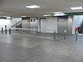
Distribution level

Access from the distribution floor to the platform level

Station name on the frosted glass walls

Elevated railway line towards Fürth


Nürnberg-Muggenhof stop
At the height of today's underground station and the intersection of Sigmundstrasse and Fürther Strasse, the Nuremberg-Muggenhof stop of the Ludwig Railway , which led from Nuremberg Ludwigsbahnhof to Fürth Ludwigsbahnhof , had existed since December 7, 1835 . Its operation was stopped on October 31, 1922 due to inflation and its tracks were removed on June 5, 1925.
.svg)
.svg)
Passenger traffic : In operation: Dürrenhof | Dutzendteich | Eibach | Erlenstegen | Fischbach | Frankenstadion | Gleißhammer | Central station | Katzwang | Laufamholz | Mögeldorf | Northeast Station | Ostbahnhof | Ostring | Rehhof | Reichelsdorf | Reichelsdorfer Keller | Rothenburgerstrasse | Sandreuth | Schweinau | Stone | Steinbühl • Closed: Buchenbühl | Doos | Fürth intersection | Fürth South | Großgründlach | Long water | Ludwigsbahnhof | Muggenhof | Neusündersbühl | Marshalling yard exit | Shunting yard depot | West | Brick | Customs House
Freight traffic : In operation: container terminal (port) | Dutzendteich | Wholesale market | Port station | Long water | North Station | Marshalling yard | Marshalling yard exit | Shunting yard depot | Marshalling yard entrance | Shunting yard fore yard • Closed: container terminal (Gostenhof) | Main freight station | Northeast Station | Northwest Station | Ostbahnhof | Südbahnhof | stockyard
Lines
| line | course |
|---|---|
|
|
Langwasser Süd - Community House - Langwasser Mitte - Scharfreiterring - Langwasser Nord - Messe - Bauernfeindstrasse - Hasenbuck - Frankenstrasse - Maffeiplatz - Aufseßplatz - Central Station - Lorenzkirche - White Tower - Plärrer - Gostenhof - Bärenschanze - Maximilianstrasse - Eberhardshof - Muggenhof - city limits - Jakobinenstrasse - Fürth Central Station - Fürth Rathaus - Fürth Stadthalle - Fuerth Hospital - Furth Hardhöhe |
The station is served by the underground line U1 . The N9 night bus also runs on weekends and before public holidays .
literature
- City of Nuremberg / Building Department and City of Fürth (Ed.): U-Bahn Nürnberg – Fürth 8 . Press and Information Office of the City of Nuremberg, Nuremberg 1982.
- Michael Schedel: Nuremberg U-Bahn Album . Robert Schwandl Verlag, Berlin 2007, ISBN 3-936573-11-5 .
Web links
- Local area map on the sides of the VGN (PDF; 79.15 KB)
- Station description on local traffic Franconia (private)
- Station pictures on cityverkehr.de (private)
Individual evidence
- ↑ Overview: These are the most used underground stations in Nuremberg on nordbayern.de, from December 27, 2019, accessed on January 6, 2020
- ^ Ludwigsbahnhof Nuremberg on nuernberginfos.de, accessed on January 25, 2018
| Previous station | Nuremberg subway | Next station |
|---|---|---|
|
City limits ← Fürth Hardhöhe |
|
Eberhardshof Langwasser Süd → |
Coordinates: 49 ° 27 ′ 42 ″ N , 11 ° 1 ′ 22 ″ E

Lines :
![]() |
|
![]() |
|
![]() • Former lines :
• Former lines :
![]() |
|
![]()
Vehicles : type DT1 | Type DT2 | Type DT3 / DT3-F | Type A | Type G1
Railway stations : Aufseßplatz | Bauernfeindstrasse | Bärenschanze | Eberhardshof | Airport | Frankenstrasse | Friedrich-Ebert-Platz | Fürth Hardhöhe | Fürth Central Station | Fürth Clinic | Fürth town hall | Fürth City Hall | Community house | Gostenhof | Großreuth near Schweinau | Gustav-Adolf-Strasse | Hasenbuck | Central station | Herrnhütte | High torture | Jakobinenstrasse | Kaulbachplatz | North Hospital | Langwasser middle | Langwasser North | Langwasser South | Lorenz Church | Maffeiplatz | Maxfeld | Maximilianstrasse | Fair | Muggenhof | Northeast Station | Northwest Ring | Opera House | Blusterer | Rathenauplatz | Rennweg | Röthenbach | Rothenburger Strasse | Scharfreiterring | Schoppershof | Schweinau | St. Leonhard | City limits | Sündersbühl | White Tower | Wöhrder Wiese | Brick