
Woehrd
|
Wöhrd
Statistical District 09 City of Nuremberg
Coordinates: 49 ° 27 '15 " N , 11 ° 5' 45" E
|
|
|---|---|
| Height : | 301-308 m above sea level NN |
| Area : | 79.1 ha |
| Residents : | 9679 (Dec. 31, 2015) |
| Population density : | 12,236 inhabitants / km² |
| Incorporation : | October 1, 1825 |
| Incorporated into: | Nuremberg |
| Area code : | 0911 |
 Location of the statistical district 9
|
|
 Wöhrd and Wöhrder See , view from the northwest, 2005
|
|
Wöhrd , a former suburb, has been a district of Nuremberg since October 1, 1825 and is now the name of the statistical district 09 .
geography
Wöhrd is located east of Nuremberg city center north of the Pegnitz , which flows here leaving the Wöhrder lake past the Wöhrder meadow . The Franconian Marienweg runs through Wöhrd .
| Neighboring statistical districts | |||||||||
|---|---|---|---|---|---|---|---|---|---|
|
.svg)
history

Wöhrd was first mentioned in a document in 1273 .
The place was fortified by ramparts and moats since the 15th century. The fortification was created along the medieval ditch through seamlessly built houses, which were windowless at the back and only provided with loopholes. Between the city gate and the Mögeldorfer Tor the fortification was called "Rahm" and between the city gate and Wollentor "the barrier".
Wöhrd was known for its mills and the dyers who lived there . The castle count's village belonged to the office of the fortress and was destroyed by the Nuremberg people during the city war in 1388. The Bartholomäuskirche, built from 1557 on, stands on the site of the chapel donated by Burgraves Friedrich and Johann (built 1396-1418, destroyed in 1552). In 1427 the imperial city of Nuremberg acquired not only the Burggrafenburg but also the place Wöhrd and subsequently set up the judicial office of Wöhrd. In the Second Margrave War in 1552, the city council had the suburb burned down, but after the end of the war rebuilt it as an artisan town and relocated the dyeing trades. During the Thirty Years War , Wöhrd was protected behind the Schwedenschanzen and was largely spared from the effects of the war. In 1796 the place came to the Kingdom of Prussia and was under its authorities until the transition to the Kingdom of Bavaria in 1806 seat of the Justice and Chamber Office Wöhrd and Gostenhof . 1810/18. In the course of the formation of the community, the community of Wöhrd came into being, which was incorporated into Nuremberg in 1818 as part of the truce . In 1825 the Wöhrder churchyard, which previously belonged to the Rennweg “community”, was incorporated into Wöhrd and thus to Nuremberg.
In 1809 a cloth manufacture was established and in 1820 the Lobenhofer cloth factory was founded as the first and only large textile company in Nuremberg. The company was given up in 1876 and acquired by the city of Nuremberg to build a waterworks. With the incorporation, urban development began to increase in Wöhrd. The Cramer-Klettsche Maschinenfabrik (today: MAN ) founded the most important industrial settlement south of Keßlerplatz in 1841, but it was relocated to Steinbühl in 1897 . During the Second World War , the suburb was destroyed by an air raid in 1943 and later rebuilt while largely retaining the layout. Due to its location on the recreational area of the Wöhrder See, which was created between 1968 and 1972, the former workers' residential area has experienced a significant increase in value.
Attractions
- The course of the former city fortifications that can be read along the street.
- The rebuilt Church of St. Bartholomew
- The old cemetery (Bartholomäusstrasse / Veilhofstrasse) with a grave burial house from 1529
- The Cramer-Klett-Park with the classical garden pavilion "Temple of Apollo"
- Historic half-timbered houses in the Rahm
Parishes
- Evangelical Reformation Memorial Church
- Evangelical Church of St. Bartholomew
- Catholic Church of St. Joseph

West and
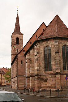
East side of the Protestant St. Bartholomew Church


education
- Nuremberg University of Music
- Technical University of Nuremberg Georg Simon Ohm
- Melanchthon High School
- Maria Ward School
- Municipal business school
- Bartholomäus School, Bartholomäusstraße 16
literature
- Hermann Rusam: Wöhrd . In: Michael Diefenbacher , Rudolf Endres (Hrsg.): Stadtlexikon Nürnberg . 2nd, improved edition. W. Tümmels Verlag, Nuremberg 2000, ISBN 3-921590-69-8 ( online ).
- Dehio : Bayern I: Franken , 2nd edition, Munich 1999, p. 683f. (Church), p. 792 (cemetery).
- Günther P. Fehring and Anton Ress: The city of Nuremberg. Brief inventory , 2nd ed. by Wilhelm Schwemmer, Munich: Deutscher Kunstverlag 1977 [un. Reprint 1982] (= Bayerische Kunstdenkmale; 10), pp. 484–489.
- Herbert May: The grave digger's house in Wöhrd - An old building with an eventful history , Nuremberg Old Town Reports, No. 35/2010
- Wilhelm Schwemmer: From the history of the parish Nuremberg-Wöhrd , Hersbruck, Karl Pfeiffers Buchdruckerei and Verlag, 1956
- Wilhelm Schwemmer: From the past of the suburb of Wöhrd , Nuremberg, Korn & Berg, 1980
- Vorstadtverein Nürnberg-Wöhrd eV (Ed.): Wöhrd - The Destruction in 1943 , Nuremberg, self-published, 1995
See also
Web links
- District data sheet Nuremberg - Statistical District 09 Wöhrd , as of 2015 (PDF; S kB)
- The Temple of Apollo
- Suburban association Nürnberg-Wöhrd from 1877 eV
Individual evidence
- ^ City of Nuremberg, Office for Urban Research and Statistics for Nuremberg and Fürth (ed.): Statistical Yearbook of the City of Nuremberg 2016 . December 2015, ISSN 0944-1514 , 18 Statistical City Districts and Districts, p. 244–245 , p. 244 ( nuernberg.de [PDF; 6.3 MB ; accessed on November 1, 2017]).
- ^ City of Nuremberg, Office for Urban Research and Statistics for Nuremberg and Fürth (ed.): Statistical Yearbook of the City of Nuremberg 2016 . December 2015, ISSN 0944-1514 , 18 Statistical City Districts and Districts, p. 19-20 , p. 19 ( nuernberg.de [PDF; 6.3 MB ; accessed on November 1, 2017]).
.svg)
.svg)
Almoshof | Altenfurt | Bärenschanze | Pearwood | White lead | Boxing Village | Brunn | Book | Buchenbühl | Doos | Dutzendteich | Eberhardshof | Eibach | Eibacher Forest | Erlenstegen | Falkenheim | Fischbach | Open air settlement | Gaismannshof | Galgenhof | Gardens near Wöhrd | Gardens behind the fortress | Garden city | Gaulnhofen | Gebersdorf | Gerasmühle | Gibitzenhof | Gleißbühl | Gleißhammer | Glockenhof | Gostenhof | Greuth | Großgründlach | Großreuth near Schweinau | Großreuth behind the fortress | Gugelstrasse | Guntherstrasse | Hammer | Hasenbuck | Herpersdorf | Herrnhütte | Himpfelshof | Holzheim | Courtyards | Courtly | Hummelstein | St. Jobst | St. Johannis | Katzwang | Kettelersiedlung | Kleingründlach | Kleinreuth near Schweinau | Kleinreuth behind the fortress | Kleinweidenmühle | Klingenhof | Royal court | Koppenhof | Kornburg | Powerhouse | Settlement of war sacrifices | Krottenbach | Long water | Laufamholz | St. Leonhard | Leyh | Lichtenhof | Tan | Loher Moos | Lohhof | Lorenz | Ludwigsfeld | Maiach | Marienberg | Marienvorstadt | Maxfeld | Middle mill | Mögeldorf | Moorenbrunn | Mooshof | Muggenhof | Mühlhof | Net stall | Neukatzwang | Neulandsiedlung | Neunhof | Neuröthenbach | Neuselsbrunn | North Station | Northeast Station | Oberbürg | Obermühle | St. Peter | Pillenreuth | Pirckheimerstrasse | Rabus | Marshalling yard settlement | Rechenberg | Rehhof | Reichelsdorf | Reichelsdorfer Keller | Rennweg | Reutles | Rosenau | Röthenbach near Schweinau | Sandberg | Sandreuth | Sheep farm | Schmalau | Schnepfenreuth | Schniegling | Schoppershof | Schweinau | Sebald | Seeleinsbühl | Spitalhof | Quarries | Steinbühl | Stone slab | Sündersbühl | Tafelhof | Clay | Tullnau | Lower guarantee | Veilhof | Vistula Garden | Weigelshof | Weiherhaus | Werderau | Westfriedhof | Wetzendorf | Wöhrd | Worzeldorf | Zerzabelshof | Brick | Customs House
(0) Old town and closer inner city : (01) Old town, St. Lorenz | (02) Marienvorstadt | (03) Tafelhof | (04) Gostenhof | (05) Himpfelshof | (06) Old Town, St. Sebald | (07) St. Johannis | (08) Pirckheimerstraße | (09) Wöhrd • (1) Further inner city belt south : (10) Ludwigsfeld | (11) Glockenhof | (12) Guntherstrasse | (13) Galgenhof | (14) Hummelstein | (15) Gugelstrasse | (16) Steinbühl | (17) Gibitzenhof | (18) Sandreuth | (19) Schweinau • (2) Further inner city belt west / north / east : (20) St. Leonhard | (21) Sündersbühl | (22) Bärenschanze | (23) Sandberg | (24) Bielingplatz | (25) Uhlandstrasse | (26) Maxfeld | (27) Veilhof | (28) Tullnau | (29) Gleißhammer • (3) Southeastern outer city : (30) Dutzendteich | (31) Marshalling yard settlement | (32) Langwasser Northwest | (33) Langwasser Northeast | (34) Beuthener Strasse | (35) Altenfurt North | (36) Langwasser Southeast | (37) Langwasser Southwest | (38) Altenfurt, Moorenbrunn | (39) Nuremberg-Feucht business park • (4) Southern outer city : (40) Hasenbuck | (41) Marshalling yard | (42) Katzwanger Strasse | (43) Dianastraße | (44) Trier Street | (45) Garden City | (46) Werderau | (47) Maiach | (48) Katzwang, Reichelsdorf Ost, Reichelsdorfer Keller | (49) Kornburg, Worzeldorf • (5) South-western outskirts : (50) Hohe Marter | (51) Röthenbach West | (52) Röthenbach Ost | (53) Eibach | (54) Reichelsdorf | (55) Krottenbach, Mühlhof • (6) Western outer city : (60) Großreuth near Schweinau | (61) Gebersdorf | (62) Gaismannshof | (63) Courts | (64) Eberhardshof | (65) Muggenhof • (7) Northwest outer city : (70) Westfriedhof | (71) Schniegling | (72) Wetzendorf | (73) book | (74) clay | (75) Almoshof | (76) Kraftshof | (77) Neunhof | (78) Boxdorf | (79) Großgründlach • (8) Northeastern outer city : (80) Schleifweg | (81) Schoppershof | (82) Sheep Farm | (83) Marienberg | (84) brick | (85) Mooshof | (86) Buchenbühl | (87) Airport • (9) East outer city : (90) St. Jobst | (91) Erlenstegen | (92) Mögeldorf | (93) Schmausenbuckstrasse | (94) Laufamholz | (95) Zerzabelshof | (96) Fischbach | (97) Well