
Bavarian premiere

The Bavarian premiere is the topographical land survey of the Kingdom of Bavaria , which was ordered by King Maximilian I Joseph in 1808 and lasted until 1864.
prehistory
Bavaria was mapped by Philipp Apian under Duke Albrecht V and represented in the Bavarian land tables from 1568.
After the French Armée du Rhin under General Moreau occupied Munich in 1800 and found no precise maps , a bureaux topographique was set up to remedy the deficiency.
Topographical Bureau
After the Peace of Lunéville , Elector Maximilian IV Joseph (later King Maximilian I), who was advised by his minister von Montgelas , founded the Topographical Bureau on June 19, 1801 , which created a complete, astronomically and topographically correct map of Bavaria should.
In the same year, under the guidance of the French military geographer Colonel Bonne (1771–1839), the base line Unterföhring – Aufkirchen was measured. Immediately afterwards, the triangulation of a large-scale trigonometric surveying network began , which lasted until 1828. The old Bavarian baseline was followed by a Franconian one from Nuremberg to Bruck in 1807 and the Rhine-Bavarian one from Speyer to Oggersheim in 1819 . During the triangulation, the main triangular network points in Bavaria were determined. As early as 1807 Colonel Bonne had created a triangular network of points of the first and second order in Upper and Lower Bavaria and the Upper Palatinate. The spire of the north tower of the Munich Frauenkirche became the zero point of the Bavarian land survey. The Topographical Atlas of the Kingdom of Bavaria , which was published in 1867, has been created since 1812 .
As early as 1801, Joseph von Utzschneider suggested forming a bureau de cadastre within the topographical bureau . After his release in the same year, this was not pursued.
Various attempts, forced by financial difficulties, failed to determine the size of properties as the basis for property tax in a simplified way without further individual measurements.
Royal Immediate Tax Assessment Commission
King Maximilian I Joseph founded the Royal Immediate Tax Surveying Commission in 1808 , which was supposed to create maps on the basis of detailed measurements for a fair and standardized property tax . The territorial changes as a result of the Napoleonic Wars resulted in a large number of different property tax systems. The property tax was the main source of income for the state at the time.
The reactivated Utzschneider became the chairman of the commission; Georg von Grünberger, Adrian von Riedl , Ignaz Ambrosius Amman, Ulrich Schiegg , Michael Riedl, Korbinian Badhauser and Thaddäus Lämmle were members of the management committee.
Since the accuracy of the previous network was insufficient for the measurement of individual properties, Johann Georg von Soldner repeated his measurement in 1808 with the new repetition theodolite developed by Georg Friedrich von Reichenbach , which was far superior to the previous instruments.
The area was measured and mapped on the measuring table outdoors. Between 1808 and 1864, more than 23,000 measuring table or first recording sheets were created. The ownership of areas was marked with the corresponding house number of the owner. On the basis of these sheets, maps were then drawn on a scale of 1: 5000 and for localities on a scale of 1: 2500, in Franconia partly on a scale of 1: 1250 and reproduced in the commission's lithographic institute . In addition, the areas of the plots were calculated and their profitability estimated. In a deed known as liquidation , the owners recognized the ownership structure established.
In 1811 the name of the commission was changed to the Royal Immediate Tax Cadastre Commission.
The royal Bavarian property tax cadastre developed from this later. Some of the data have been part of the land register since 1900 . The Bavarian State Office for Digitization, Broadband and Surveying is responsible for the further development and updating of the cadastre . In the stone cellar there, the printing plates made of Solnhofen limestone that were necessary for the lithographs of the time are stored .
In addition to current maps, the BayernAtlas also contains historical maps in the form of position maps and the first recording sheets.
gallery
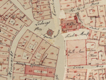
Ortsblatt (first recording sheet) Freising (1809)
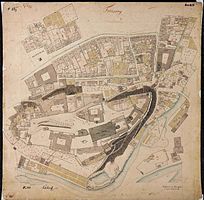
Map of the first recording, Augsburg city center (between 1828 and 1864)

Original position sheet 1: 25.000, Munich (1853)
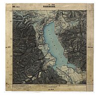
Original position sheet 1: 25.000, Tegernsee (1862)

.jpg)

See also
Web links
- BayernAtlas
- Historical land maps, website of the Bavarian Surveying Administration
- Topographic Atlas of Bavaria (112 map sheets on a scale of 1: 100,000)
Individual evidence
- ↑ Hans Wolff: Bavaria in the image of the map - Carthographia Bavariae . Ed .: Bayerische Staatsbibliothek. 2nd Edition. Anton H. Konrad Verlag, Weißenhorn 1991, ISBN 3-87437-301-0 , p. 224 .
- ↑ K. Tax Cataster Commission in association with the topographical bureau of the K. General Staff (ed.): The Bavarian land survey in its scientific basis . Academic book printing by F. Straub, Munich 1873, p. 3, 4 ( full text in Google Book Search).
- ↑ K. Tax Cataster Commission in association with the topographical bureau of the K. General Staff (ed.): The Bavarian land survey in its scientific basis . Academic book printing by F. Straub, Munich 1873, p. 67 ( full text in Google Book Search).
- ↑ Hans Wolff: Bavaria in the image of the map - Carthographia Bavariae . Ed .: Bayerische Staatsbibliothek. 2nd Edition. Anton H. Konrad Verlag, Weißenhorn 1991, ISBN 3-87437-301-0 , p. 225 .
- ↑ Max Seeberger, Frank Holl: How Bavaria was measured. Booklets on Bavarian History and Culture, Volume 26, House of Bavarian History, 2001, p. 32 (p. 33 in PDF)
- ^ History of surveying in Bavaria on ldbv.bayern.de
- ↑ How Bavaria was measured, p. 35 (p. 36 in the PDF)
- ↑ How Bavaria was measured, p. 35 (p. 36 in the PDF)
- ↑ Historical land maps on ldbv.bayern.de
- ↑ That royal. bayer. Property tax register on ldbv.bayern.de