Main triangular network points in Bavaria
The original main triangular network points (HDNP) of the Bavarian triangulation network ( network of the first order ) are shown on the map of the Topographical Bureau from 1831.
Carrying out measurements from 1801
A topographic bureau was founded in Munich on June 19, 1801 to create a topographic map . The main task was initially to measure the base line Unterföhring – Aufkirchen with the main triangular network, the secondary network and the topographical mapping of individual areas.
The first step in creating the triangular mesh was to define prominent points across the country and determine their location in the earth 's graticule. As a rule, these points were mountain peaks or towers with a direct line of sight to the closest points. They were sometimes very far apart, sometimes up to 80 kilometers.
The management of the Topographic Bureau commissioned the French geographer Charles Rigobert Bonne to select the main survey points and to measure the triangular network.
When the southern Bavarian network was connected to the Franconian network in 1807, the mathematician and astronomer Ulrich Schiegg determined a second baseline with a length of 13.8 kilometers, which was used to check the accuracy of the angle measurements.
From 1808, under the direction of Johann Georg von Soldner, the network with theodolites from the Munich workshop of Georg von Reichenbach was measured again and with even greater accuracy.
The measurements for the main triangular network were completed in 1825. It included 131 trigonometric points that were 10.8 to 88.7 kilometers apart. They were often located on church towers or mountain peaks because of the wide view required for the follow-up measurements. If forests obstructed the view, long aisles had to be cut or wooden observation towers were built, some of which were considerable.
Main triangular network points in Bavaria around 1831 (selection)
In the following, the designation of the points is based on the map from 1831. The exact description of the control points can be found in the official compilation from 1956.
Benedictenwand (Benediktenwand)
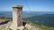
The point 47 ° 39 ′ 12 ″ N , 11 ° 27 ′ 56 ″ E is 1801 meters at the highest point of the Benediktenwand . Benediktenwand signal was determined trigonometrically in 1802. The point was initially not insured. The position of the HDNP at the site of the summit cross erected in 1877 could not be clearly proven. In 1949, in the immediate vicinity of the cross, a 1.25 meter high brick pillar covered with concrete mortar was erected, which has since formed the new center of the station.
Status 1956: Benediktbeuern , Benediktenwand, fixed point no.6.
Brennberg Castle Tower (Brennberg)
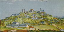
The point 49 ° 4 '20 " N , 12 ° 23' 55" O is at 650.9 meters immediately to the north of the map internal mountain on the grounds of the ruin of Burg internal mountain . HDNP of the first national survey was a square tower of the early Thurn and Taxis castle covered with wooden shingles. When the tower collapsed in 1890, the original survey point was lost. When the triangular network was supplemented in the years 1925 to 1927, a new main network point of the first order was determined, with the angle measurements being carried out on a scaffold signal from an observation height of 18 meters. It is a seam point between the Upper Danube and the southern Bavarian main triangular network.
Dreifaltigkeit (Dreifaltigkeitsberg (Rimbach))
The original HDNP Trinity Tower is at 48 ° 40 ′ 29 ″ N , 12 ° 23 ′ 30 ″ E in the church tower on the 473 meter high Dreifaltigkeitsberg in the Rimbach district , Moosthenning municipality in Lower Bavaria. In 1937 a replacement point was chosen called Mühlhausen, Vogelsang northwest 2.1 kilometers away.
Habsberg (pilgrimage church on the Habsberg)
The Habsberg point is at 49 ° 18 '48 " N , 11 ° 37' 55" E and was represented by the center of the helm post of the church tower on the Habsberg , 38 meters above the ground. The first angle measurements were made in 1803.
Status 1956: Oberwiesenacker, Habsberg, Fixed Point No. 63.
Hohenstein
The point 49 ° 35 ′ 12 ″ N , 11 ° 25 ′ 20 ″ E lies at 627 m immediately southwest of the village of Hohenstein on Hohenstein Castle . Hohenstein Signal was determined trigonometrically in 1809. The point was represented by the top of a turret in the middle of the roof of Hohenstein Castle. The instrument stand was perpendicular below within the turret. The turret was demolished in 1940.
Status 1956: Algersdorf, Hohenstein, Fixed Point No. 1.
Johannbrunn (Johannesbrunn)
The point Johannesbrunn pyramid is located on an elevation of 520 meters, about 1.5 km northeast of Johannesbrunn district Vilsbiburg at the coordinates 48 ° 29 '14 " N , 12 ° 28' 27" O . Observations on the pyramid began in 1804. In 2012, the point was in the thick undergrowth that was inaccessible by a fence.
Status 1956: Hölsbrunn, Johannesbrunn, Fixed Point No. 36.
Mitbach (Mittbach (Isen))
The point 48 ° 9 '52 " N , 12 ° 1' 47" E is located in the village of Mittbach at an altitude of 623.5 meters around 34 kilometers east of Munich in the Wasserburg district . The first angle measurements to the Mittbach Tower point were made in 1803. At that time, an observation stand was installed directly under the tower's dome with four openings of around 30 × 120 centimeters in the tower roof. HDNP was the helmet pole . For the European degree measurement in 1904, the angle measurement was carried out in the observation room on a massive brick pillar. On the occasion of the preparation of the new Bavarian main triangular network, a wooden observation pillar was built into the dome of the tower in 1938 and the location of the plumbed helmet pole was recorded by a light screw on the table.
As of 1956: Mittbach, Fixed Point No. 53.
Ox head
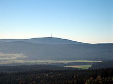
The point 50 ° 1 ′ 51 ″ N , 11 ° 48 ′ 35 ″ E lies on the summit of the 1024 meter high Ochsenkopf in the Fichtel Mountains. Ochsenkopf Pyramid was insured in 1850 by a cross carved into the rock and 4 ancillary insurance policies (crosses in the rock). The letters HDNP were carved into the cross marking the center in 1879 . The point is about 12 meters south of the south corner of the Asenturm restaurant.
In 1876, about 22 meters southeast of the HDNP at 50 ° 1 ′ 50 ″ N , 11 ° 48 ′ 36 ″ E, a six meter high stone pillar was built for the Saxon land surveying and international geography . After being damaged, it was restored to a height of 4.5 meters in 1927.
As of 1956: Bischofsgrün forest district, Ochsenkopf, fixed point no.10.
Schweidenkirchen (Schweitenkirchen)
The Schweidenkirchen tower point at 48 ° 30 ′ 20 ″ N , 11 ° 36 ′ 24 ″ E was first measured in 1806 in the lantern of the 31 meter high church tower. The church of St. Johannis the Baptist is 533 meters above sea level in Schweitenkirchen in the Pfaffenhofen an der Ilm district. In 1906, the church roof was given a height that far exceeds the sound openings of the bell chamber of the tower. As a result, angle measurements in the northern sound opening were no longer possible.
Status 1956: Schweitenkirchen, Fixed Point No. 85.
Teichitz (Teuchatz)
The name of this point on the map at 49 ° 51 '37 ″ N , 11 ° 4 ′ 24 ″ E is probably the pronunciation of the name of the nearby place Teuchatz in Franconian dialect. The point is 566.7 meters above sea level on the Weidenberg at a distance of 1.8 kilometers southwest of Teuchatz. In the Münchner Tagblatt of June 3, 1830 it was reported that on May 25, 1830 a violent storm "knocked over the tower built for trigonometric measurements at Teuchatz". In 1843 the point was insured with underground marks and marked with an HDNP stone in 1868. Because of the uncertainty of the location of the HDNP stone compared to the old center, the point was redefined in 1905/06, with only a linear change of 12.4 centimeters compared to the old coordinates.
Status 1956: Zeegendorf, Weidenberg (Teuchatz), fixed point no.103.
Wülzburg
The point 49 ° 1 '30 ″ N , 11 ° 0 ′ 16 ″ E is on the Wülzburg in a former wooden observation tower on the roof of the former barracks. The angle measurements began in 1803.
Status 1956: Weißenburg, Wülzburg, fixed point no.99.
Individual evidence
- ↑ a b c Topographical Bureau: Main triangular network for the topographical atlas of the Kingdom of Bavaria , 1831, Bayerische Staatsbibliothek, Mapp. XI, 57ge, Munich ( option for high-resolution maps )
- ↑ a b Max Seeberger, Frank Holl. House of Bavarian History (ed.): How Bavaria was measured . Booklets on Bavarian history and culture, Volume 26, 2001, ISBN 3-927233-77-3
- ↑ Bayerisches Landesvermessungsamt (Ed.): Das Bavarian Landesvermessungswerk, Book 6 = The new Bavarian main triangular network, Part I = Coordinate Directory, Munich, 1956
- ↑ a b Bayerisches Landesvermessungsamt (Hrsg.): Das Bavarian Landesvermessungswerk, Book 6 = The new Bavarian main triangular network, Part III = Descriptions of fixed points, Munich, 1956
- ↑ Communication in Münchner Tagblatt No. 151 of June 30, 1830


