
Benedict wall
| Benedict wall | ||
|---|---|---|
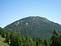
 North face of the Benediktenwand |
||
| height | 1801 m above sea level NN | |
| location | Bavaria , Germany | |
| Mountains | Bavarian Prealps | |
| Dominance | 13.9 km → Demeljoch | |
| Notch height | 943 m ↓ Kesselberg | |
| Coordinates | 47 ° 39 '11 " N , 11 ° 27' 56" E | |
|
||
| rock | Wetterstein lime | |
| Age of the rock | Triad | |
| Normal way | From Benediktbeuern via the Tutzinger Hütte and the west climb to the summit | |
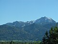
 View from Benediktbeuern to the Benediktenwand |
||

The Benediktenwand (already known as montem sancti Benedicti around 1300 ) is a 1801 m high mountain ridge in the Bavarian Prealps between the Loisach and Isar rivers, as well as the Jachenau in the south and the Benediktbeuern monastery in the north, from which it takes its name.
geography
From west to east, the Benediktenwandgruppe includes the summits Rabenkopf (1555.5 m), Glaswand (1496 m), Benediktenwand (1801 m), Hennenkopf (1614 m), Probstenwand (1589 m), Achselköpf (1600–1710 m), Latschenkopf (1712 m), Hinterer Kirchstein (1667 m), Vorderer Kirchstein (1670 m) and Schrödelstein (1548 m). To the east, the Brauneck (1555 m) borders the summit group. The Tutzinger Hut (1327 m) is located directly under the north face of the Benediktenwand .
The Benediktenwand carries the west summit with the cross on its back and the east summit 338.51 m away without any significant markings. A determination of the height difference using a precision leveling system with a return trip in autumn 2012 showed that the east summit is a good 13 cm higher than the west summit. The heights were also determined: for the west summit 1,800.477 m above sea level. NHN and for the east summit 1800,612 m above sea level. NHN .
During the Würme Ice Age, the summit of the Benediktenwand protruded approx. 600 m from the ice flow of the Walchensee and Isar glaciers (tributaries of the Inntal glacier ) as Nunatak .
The western summit is the main triangular network point of the Bavarian land survey.
Ascent
The normal ascent to the Benediktenwand leads from Benediktbeuern via the Tutzinger hut and the west or east path to the summit. Also from Jachenau over the Glaswandscharte or over the Bichler Alm and the Altweibersteig and from the Isarwinkel climbs lead to the summit. Other paths lead through the Längental over the Probstalm (1376 m; Alpine Club hut not open to the public ) and from Brauneck to Benediktenwand; the Brauneck is accessible via a cable car from Lenggries .
Numerous climbing routes from difficulty level II to VIII lead through the north face of the Benediktenwand, which is visible from afar . Some climbing routes also lead through the south face.
Ibex
Since September 1959, the north and south flanks of the Benediktenwand have been animated by ibex from the goat family. At that time, a mighty ibex migrated from the mountains for the first time and reported to the Jachenau forestry office . After the introduction of two goats and two goats each from Switzerland in June 1967, a colony of more than 100 animals (1998) formed within 30 years , so that lately some of them have had to be released for hunting. In order to rule out diseases and lack of food, the ibex colony should be limited to around 80 animals. The ibex family is one of the five populations of ibex in Germany. They form groups there and, due to the lively tourism, show little fear of people. During the summer the animals mostly spend on the shady north side of the Benediktenwand, the winter more on the less snowy south side.
In the summer of 2004 a bronze plaque was inaugurated on the south side of the Benediktenwand on the large rock at the entrance to the “Altweibersteiges” above the Bichler Alm. The blackboard briefly describes the history of the ibex colony and names the supporters Alfons Goppel , August Moralt, Franz Burda and the long-time supervisors Matthias Müller from Jachenau and Josef Schmidt from Benediktbeuern. The board was designed by Josef Oswald, "ErbhoferSepp" from Jachenau.
Say
According to a folk legend described by Johann Nepomuk Sepp , the Benedict wall “rests on four golden pillars and hides immeasurable treasures inside.” According to the legend, a boy from Wackersberg got lost and discovered a gold bubbling fountain. Something similar is said about the Probstenwand in the vernacular: “In ancient times one saw gold cones hanging down in a hole deep in the Probstenwand, and people came up from Munich; you can still meet glittering stones on the ground. "
gallery

The Benediktenwand from Gaißach
The Benediktenwand from the Autobahn towards Garmisch (taken south of Penzberg)
West ridge and south flank of the Benediktenwand from the Achala Alm

Ibex in the Benediktenwand area

Draft of the bronze plate for the history of the Steinwild family on the Benediktenwand


Individual evidence
- ↑ Geological map of Bavaria with explanations (1: 500,000). Bavarian Geological State Office, 1998.
- ↑ BHStA, KL Benediktbeuern no. 9, sheet 47 verso
- ↑ Federal Office for Cartography and Geodesy , State Office for Surveying and Geoinformation Bavaria : Digital Topographical Map 1: 50,000, BayernAtlas , accessed on April 1, 2018.
- ↑ Gudelius, Jost jun .: Determination of the difference in altitude between two mountain peaks with different measurement methods , Bachelor thesis at the Munich University of Applied Sciences, Faculty 08, Geoinformation and satellite positioning, winter semester 2012/2013.
- ^ Map (1912) by Raimund von Klebelsberg in Rolf KF Meyer, Hermann Schmidt-Kaler: In the footsteps of the Ice Age south of Munich - eastern part , ISBN 3-931516-09-1 .
- ^ Jost Gudelius: The Jachenau . Jachenau 2008, ISBN 978-3-939751-97-7 , p. 205
- ↑ Johann Nepomuk Sepp: Old Bavarian saga treasure. Munich 1867, pp. 1–2.