
Längental (Kochel Mountains)
| Longitudinal valley | ||
|---|---|---|
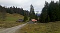
.jpg) Längental with a view of the Benediktenwandgruppe |
||
| location | Bavaria , Germany | |
| Waters | Arzbach | |
| Mountains | Bavarian Prealps | |
| Geographical location | 47 ° 40 '35 " N , 11 ° 30' 32" E | |
|
||
| length | 5 km | |

The Längental is created on the northern slopes of the Benediktenwand below the Probstenwand . The Arzbach runs throughout the valley , initially on the alpine pastures of various alpine farms, e.g. B. the Längentalalm and the Gabrielalm . In the further course the valley floor changes to a gorge until it meets the Lettenbach .
bases
The serviced accommodation facility of the Kirchsteinhütte is located in the valley . The Längentalalm is temporarily managed.
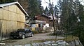
Kirchsteinhütte

Längentalalm
Gabrielalm


Web links
Commons : Längental - collection of images, videos and audio files