
Arzbach (Isar)
|
Arzbach Arzbach (Isar) |
||
.jpg) Arzbach in the Längental |
||
| Data | ||
| location |
Bavaria
|
|
| River system | Danube | |
| Drain over | Isar → Danube → Black Sea | |
| source | in Probstalm 47 ° 39 '27 " N , 11 ° 29' 12" O |
|
| Source height | over 1380 m | |
| muzzle | At Wackersberg- Arzbach from the left into the Isar Coordinates: 47 ° 42 '33 " N , 11 ° 33' 41" E 47 ° 42 '33 " N , 11 ° 33' 41" E |
|
| Mouth height | approx. 670 m | |
| Height difference | approx. 710 m | |
| Bottom slope | approx. 75 ‰ | |
| length | approx. 9.5 km | |
| Left tributaries | Lettenbach | |
The Arzbach is a left tributary of the Isar in the Upper Bavarian district of Bad Tölz-Wolfratshausen .
geography
course
The Arzbach rises at a little over 1380 m above sea level. NHN north-east of the Benediktenwand near the Probstalm on the edge of the municipality of Lenggries . At the beginning it flows approximately northeast and through the Längental past the Längentalalm. At about 780 m above sea level. NHN it takes up the Lettenbach from the west . After about two thirds of its run, it reaches around 730 m above sea level. NHN from the Alpine foothills out the flat and now open western slope of the wide Isar valley with the first rural farms not far from the stream. From there it moves for a long time in a wide gravel bed east-northeast, initially lined with gallery forest strips. On its last half kilometer between the Wackersberg church village Arzbach on the left bank and parts of the settlement of the Lenggries church village Schlegldorf, it then moves east. It flows out near the Arzbacher Auensportplatz at about 670 m above sea level. NHN last of all in the municipality of Gaißach from the left into the Isar .
The municipal boundary between Wackersberg on the left and Lenggries on the right follows the Arzbach for most of its course. It flows into just a small corner of the Gaißbach municipality on this side of the Isar.
Tributaries
From the source to the mouth. Selection.
- Brandweingraben, from the right to the Längentalalm
- Lead trench, from the left
- Deep trench, from the right
- Klammgraben, from the left
- Lettenbach , from the left
- Kaltengraben, from the left
- Pitzengraben, from the right
- Ratzenbachgraben, from the left
All of these tributaries reach the Arzbach in the area of the Alpine foothills. In the open corridor of the western Isar valley there is an approximately 6-hectare quarry pond of active gravel mining, about a quarter of a kilometer to the right of the run.
Web links
gallery
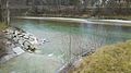
The Arzbach flows into the Isar

The Arzbach

The Arzbach

The Arzbach in the Längental


