
Gaissach
| coat of arms | Germany map | |
|---|---|---|

|
Coordinates: 47 ° 45 ' N , 11 ° 35' E |
|
| Basic data | ||
| State : | Bavaria | |
| Administrative region : | Upper Bavaria | |
| County : | Bad Toelz-Wolfratshausen | |
| Height : | 735 m above sea level NHN | |
| Area : | 38.55 km 2 | |
| Residents: | 3097 (Dec. 31, 2019) | |
| Population density : | 80 inhabitants per km 2 | |
| Postal code : | 83674 | |
| Primaries : | 08041, 08042 | |
| License plate : | TÖL, WOR | |
| Community key : | 09 1 73 124 | |
| Community structure: | 23 parts of the community | |
| Address of the municipal administration: |
Bahnhofstrasse 8 83674 Gaißach |
|
| Website : | ||
| Mayor : | Stefan Fadinger (non-party) | |
| Location of the community Gaißach in the Bad Tölz-Wolfratshausen district | ||
  |
||

Gaißach is a municipality and a parish village of the same name in the Upper Bavarian district of Bad Tölz-Wolfratshausen in the Isarwinkel .
geography
Geographical location
The widely scattered municipal area is at an altitude of 660 to 740 m above sea level. NN . The place Gaißach is about 2 km southeast of Bad Tölz , at the foot of the local mountain Rechelkopf ( 1328 m ), with Gaißach-Dorf enthroned on a hill above all other districts. The largest elevation is at 1562 m in the southeast of the community on Fockenstein . The Grosse Gaißach , which gives the entire community its name, flows from Attenloher Filzen and the Kleine Gaißach that flows into it through the Mühl district into the Isar . To the south you have a clear view of the Bavarian and Tyrolean Limestone Alps and the Karwendel Mountains .
Gaißach, together with the neighboring municipality of Wackersberg to the west, forms the northern border of the Isarwinkel . The community also borders Bad Tölz and Greiling in the north, Bad Wiessee in the east and Lenggries in the south .
The Isar lies between Bad Tölz and Lenggries completely on the Gaißacher municipality area, which in this area extends relatively far across this mountain river to the west to the municipality border (Wackersberg).
Community structure
The municipality has 23 officially named municipal parts (the type of settlement is indicated in brackets ):
|
|
At the ferry , Schalch unterm Berg and Winet there are no officially named parts of the municipality.
history
Settlement of the area is due to excavations of barrows and the finds found in them until the 2nd century BC. Demonstrable. Gaißach was first mentioned in a document in 817 as Kaizahu . From Kaizahu through Keizan, Kazzah, Gaizah, the current place name developed over time. The Kaizahu are said to have been an early lordly family of the Gaißach Urhofmarket. The area of today's Gaißach was probably cleared and systematically settled in the second half of the 8th century. With limited usage rights, farmers and craftsmen initially settled here.

Around 1300 the Isarwinkel is completely settled and the villages and corridors show their features as they have been preserved to this day. In the 16th century there were already 125 farms in Gaißach owned by around 10 landlords, as well as 12 free farmers. Like the entire Isarwinkel, Gaißach also suffered from the Thirty Years' War and almost the entire population was swept away by the plague . Before that, the Gaißach team helped the Tölz team to defend Tölz against the Swedes.
During the Austrian War of Succession , Colonel Franz von der Trenck invaded the Isarwinkel in 1742 with his plundering and robbing Pandours . Because a Gaißacher allegedly murdered one of his generals near Dietramszell, Trenck had 28 properties burned down in Gaißach on May 22, 1742 and killed 10 innocent people. The Pandurs were later driven out again through a merger of Isarwinkler farmers. Since then, the "Chapel of the Burned Down Cross" has existed as a memorial in the Puchen district.
In 1818, as part of the administrative reforms in the Kingdom of Bavaria , Gaißach became an independent political municipality. When the Holzkirchen – Lenggries railway from Bad Tölz to Lenggries was expanded in 1924 , Gaißach was also connected to the rail network. During the municipal reform in 1978 , Gaißach remained an independent municipality at its own request.
Population development
Between 1988 and 2018 the municipality grew from 2,634 to 3,136 by 502 inhabitants or 19.1%.
politics
Municipal council
The municipal council has 16 members. Another member and chairman of the municipal council is the first mayor.
Election results and distribution of seats:
| Nomination | Seats 2014-2020 |
Share 2014–2020 |
Seats 2020–2026 |
|
| CSU / Free Electoral Community | 5 seats | (33.4%) | 5 seats | |
| FW | 5 seats | (30.3%) | 6 seats | |
| Independent citizen list | 4 seats | (23.0%) | 2 seats | |
| Free Gaißacher list | 2 seats | (13.3%) | 3 seats |
mayor
The first mayor is Stefan Fadinger. He took office on October 1, 2012, after he was elected to succeed Nikolaus Trischberger on July 1, 2012 via the list connection “CSU / Free Electoral Community”. On March 15, 2020, he was confirmed with 94.26% of the valid votes for another six years.
coat of arms
|
|
Blazon : "In green a slanting left silver wave bar, on top of which a golden flaming sword is placed." |
The green ground represents the forest and meadow landscape of Gaißach, the wavy bar refers to the eponymous brook Gaißach and the flaming sword is the symbol of St. Michael , the patron saint of the parish church and the parish of Gaißach. The current coat of arms of the community Gaißach has only existed since 1959. It was designed by the Tölz architect Ernst Rössner.

Culture and sights
In Gaißach is the late Gothic Catholic parish church of St. Michael , which, after the upper tower section collapsed in 1624, was built in 1649 in the baroque form with the onion dome that still exists today . This church was rebuilt in 1735 and the magnificent frescoes by the painter Christoph Anton Mayr were created around 1761 . The altar dates from 1910, the tabernacle from 1736 and most of the furnishings from the mid-18th century.

The rectory near the church dates back to the second half of the 18th century. In this parsonage you can see a wonderful, large nativity scene in the oriental style during Advent. In 1550 the Gaißacher refused to continue burying the dead from Lenggries here, as they had to do for centuries, and created their own cemetery here. In addition to the cemetery directly at the church, Gaißach has had a new, larger cemetery on the northeast edge of the village district since 1994.
Like all villages in the Isarwinkel , Gaißach is also rich in old farms and craftsmen's houses. They can be found in all districts and mostly date from the 17th and 18th centuries, as do the numerous small chapels. In 1998, across from the church, the war memorial was erected in honor of those who fell in the Franco-German War and the two world wars.

To the north-east of Gaißach is the Korona Field , a large, listed prehistoric barrow field . A protected natural monument is also the hedge landscape , long, continuous hedges made of tall bushes and trees that were once built to demarcate the grazing areas. The hedge landscape extends south to Lenggries and in the east mostly to the mountain properties (meadows / mountain pastures) also known as Traten . This landscape can be overlooked from the Sonntagrats , a hill ( Schürfenkopf , 1096 m) on the way to the Rechelkopf.
On the northern border of Gaißach there is a small plague cross made of tuff stone. It was installed there after the Thirty Years War . Back then, when the plague raged in the area, people from Tölz wanted to make a pilgrimage to the Gaißach St. Michael Church (Bittgang). However, they were driven back halfway by angry Gaissachers, who feared infection, with pitchforks and flails. Irony of fate: Tölz was not hit as hard by the plague as Gaißach, which was almost completely depopulated. However, the Gaissachers later erected this cross as atonement for their hardness of heart. Approx. In 1985 the old cross was exchanged for a new one due to severe weathering. The original is in the Gaißach town hall.
Soil monuments
economy
Gaißach has remained an independent municipality to this day, in which agriculture and forestry are firmly anchored. Nevertheless, tourism is also becoming more and more important, which is why there are numerous offers, accommodation and inns in this regard.
traffic
- Bundesstrasse 13 and Bundesstrasse 472
- Holzkirchen – Lenggries railway line , Gaißach and Obergries stops .
- Bus routes of the Regionalverkehr Oberbayern (RVO)
Public facilities
Healthcare
- Specialist clinic Gaißach of the German Pension Insurance Bavaria South , rehabilitation clinic for chronically ill children, adolescents and young adults. The specialist areas include diseases of the respiratory tract, skin and metabolism, as well as gastrointestinal diseases and obesity.
Educational institutions
- Elementary and middle school Gaißach
- Kindergarten St. Michael

Offices
- Town hall and municipal administration in Mühl
- Catholic parish office St. Michael in the parish association Gaißach-Greiling-Reichersbeuern in village
- Evang. Parish office Bad Tölz
Leisure and sports facilities
- Ski lift
- Sports field in Obergries (of the SC Gaißach ) with soccer field, asphalt track for stick shooters, natural ice stadium
- Shooting range (air rifle, air pistol and small caliber)
Events and festivals
- Putting up the maypole
- Corpus Christi procession
- Church patronage (September 29th) "Michaelmas"
- Solid Fat ( cruel ball , straw shooting, Tequilaboi, Schnabler- / annoyance Ball)
- "Back international Schnablerrennen ". A fun race with so-called “Schnablern” (large horn sledges ) that takes place during the carnival season (since 1928) when there is enough snow . The Schnabler drive near the district of Lehen, down the Rechelkopf through the forest and on the last stretch on the open slope should jump with the sledge over a natural bump that serves as a ski jump to the finish (where it usually crashes and the vehicles break) . The disguised drivers (partly also sleds) should drive the race as fast, original and spectacular as possible. The drivers of the sledges must be locals, foreigners are only allowed as co-drivers (only two drivers in total). This race is a real crowd puller and made Gaißach known nationwide. The Schnablerrennen has been taking place in its current form since the post-war period.
Personalities
- Caspar Haslinger (1858–1921), also called Lexenkaspar, Bavarian Wildschütz
- Hermann von Oppeln-Bronikowski (1899–1966), Olympic champion in dressage and major general, died in Gaißach
- Lotte Neumann (1896–1977), German actress, screenwriter and producer, died in Gaißach
- Leonhard Pföderl (* 1993), German national ice hockey player and silver medalist at the 2018 Winter Olympics , from Gaißach
- Gerhard Waldherr (* 1960), award-winning journalist, publicist and book author, from Gaißach
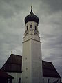
Parish Church of St. Michael

Farmhouse

Way to the Rechelkopf

War memorial
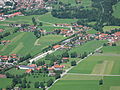
Aerial view of Gaißach (districts Mühl and Wetzl)

Aerial view of the Sunday installments and the Rechelkopf (center left)


Web links
Individual evidence
- ↑ "Data 2" sheet, Statistical Report A1200C 202041 Population of the municipalities, districts and administrative districts 1st quarter 2020 (population based on the 2011 census) ( help ).
- ^ Community Gaißach in the local database of the Bavarian State Library Online . Bayerische Staatsbibliothek, accessed on September 6, 2019.
- ↑ Greetings from the mayor. Gaißach community, accessed on July 15, 2020 .
- ^ Entry on the coat of arms of Gaißach in the database of the House of Bavarian History

Cities: Bad Tölz | Geretsried | Wolfratshausen
Municipalities: Bad Heilbrunn | Benediktbeuern | Bichl | Dietramszell | Egling | Eurasburg | Gaissach | Greiling | Icking | Jachenau | Kochel am See | Königsdorf | Lenggries | Münsing | Reichersbeuern | Sachsenkam | Schlehdorf | Wackersberg
Unregulated areas in the Bad Tölz-Wolfratshausen district of
Pupplinger Au |
Wolfratshauser Forest