
Computing head
| Computing head | ||
|---|---|---|
 |
||
| height | 1330 m | |
| location | Bavaria , Germany | |
| Mountains | Bavarian Prealps | |
| Dominance | 2.8 km → Luckenkopf | |
| Notch height | 310 m ↓ saddle between Gronetseck and Mitterberg | |
| Coordinates | 47 ° 43 '20 " N , 11 ° 37' 28" E | |
|
||

The Rechelkopf is a 1330 m high mountain in the Bavarian Prealps , which belongs to the municipality of Gaißach im Isarwinkel . Together with the Sulzkopf in the north and the Mitterberg in the east, it forms an approx. 2 km long mountain ridge.
In the German Alpine Association , this mountain is assigned to the Waakirchen section . The club hut of this section, the Sigriz-Alm, is located on the northern slope .
If there is enough snow, the popular Schnablerrennen takes place annually at the carnival time on the western slope (Gerstland) .
During the Würme Ice Age, the alpine gate of the Isartal glacier was located between the Rechelkopf and the Blomberg . Here the Isartal glacier moved at a height of about 1000 m above sea level. NN through.
The ascent from Gaißach, either from the district of Lehen or from Grundern , takes place via the Sonntratssteig , which leads to the summit of the Rechelkopf via the south-facing hill Sonntrats ( 1096 m , also known as Sunndraht , with a small private summit hut). Between Gaißach-Lehen ( 680 m ) and the summit there is a difference in altitude of around 650 m. The ascent is considered an easy hike and is therefore also suitable for children. The ascent takes about two hours, depending on your fitness level. The Sunday advice is worth a break, as it serves as a beautiful “viewing balcony” from which the Isarwinkel, the Benediktenwand and especially the protected natural monument, the hedge landscape, called Traten , can be seen. At about 1123 m there is the small Schweigeralm chapel, which invites you to take a break.
Overall, the route, which is completely forested, is uncrowded, calm and varied. The Rechelkopf is also popular in early spring and late autumn when the higher surrounding mountains are still or are already covered in snow. From the east, the mountain can be climbed from Waakirchen or from Marienstein via the Sigrizalm.
Sunday advice or sun wire on the south side of the mountain
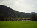
Farmhouses at the foot of the Rechelkopf

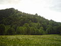
Southwest side

Sonntratn and Rechelkopf (center / left)


literature
- Christian Schneeweiß: Kompass Wanderbuch - Tölzer Land, Isarwinkel . 2002, ISBN 3-85-491929-8
- Eugen E. Hüsler: Rother hiking guide - Isarwinkel . 2004, ISBN 3-76-334006-8
- Topographic map Bad Tölz - Lenggries . ISBN 3-86-038485-6
- Alpine Club Map Bavarian Alps (1: 25000) BY13 Mangfall Mountains West
Individual evidence
- ↑ Federal Office for Cartography and Geodesy , State Office for Surveying and Geoinformation Bavaria : Digital Topographical Map 1:50 000, BayernViewer ( Memento of the original from April 13, 2014 in the Internet Archive ) Info: The archive link was inserted automatically and has not yet been checked. Please check the original and archive link according to the instructions and then remove this notice. , accessed August 4, 2010
- ↑ Map v. Klebelsberg 1912.