
Egling
| coat of arms | Germany map | |
|---|---|---|

|
Coordinates: 47 ° 55 ' N , 11 ° 31' E |
|
| Basic data | ||
| State : | Bavaria | |
| Administrative region : | Upper Bavaria | |
| County : | Bad Toelz-Wolfratshausen | |
| Height : | 609 m above sea level NHN | |
| Area : | 74.05 km 2 | |
| Residents: | 5466 (Dec. 31, 2019) | |
| Population density : | 74 inhabitants per km 2 | |
| Postal code : | 82544 | |
| Primaries : | 08176, 08170, 08171, 08178 | |
| License plate : | TÖL, WOR | |
| Community key : | 09 1 73 120 | |
| Community structure: | 33 parts of the community | |
| Address of the municipal administration: |
Rathausstrasse 2 82544 Egling |
|
| Website : | ||
| Mayor : | Hubert Oberhauser (Free Association of Voters) | |
| Location of the municipality of Egling in the Bad Tölz-Wolfratshausen district | ||
  |
||


Egling is a municipality in the Upper Bavarian district of Bad Tölz-Wolfratshausen .
geography
location
Egling is in the north of the district, on the border with the Munich district . The community is located directly to the east of the Isar and has a share of its nature reserves. The main town of Egling is about five kilometers east of the river and the city of Wolfratshausen , Munich is about 30 kilometers to the north.
Community structure
The municipality has 33 officially named municipal parts (the type of settlement is indicated in brackets ):
|
|
|
|
history
The place Egling was first mentioned in 804. The Tegernsee monastery owned the land in the municipality and occupied the parish of Egling. The local noble family of the Egling, which can be traced back to Egling from the 13th to the 15th century, died out around 1511/15. Egling in today's administrative district of Upper Bavaria belonged to the Munich Rent Office and the Wolfratshausen district court of the Electorate of Bavaria and became an independent political municipality in the course of the administrative reforms in the Kingdom of Bavaria in 1818. Until the district reform in 1972, the municipality of Egling belonged to the Wolfratshausen district .
The municipality of Egling in its current form was created on January 1, 1973 through the voluntary amalgamation of the municipalities of Egling, Ergertshausen, Moosham, Neufahrn and Thanning. On May 1, 1978, the municipalities of Deining and Endlhausen were incorporated as part of the regional reform .
Population development
Between 1988 and 2018, the municipality grew from 4,130 to 5,477 inhabitants by 1347 inhabitants or 32.6%.
politics
Municipal council
In the term of office from May 2020 to April 2026, the municipal council has 20 members. In the local elections on March 15, 2020 , the turnout was 68.18% (2014: 67.00%). The choice brought the following result:
| CSU | 7 seats | (33.95%) |
| SPD | 1 seat | (6.40%) |
| Free community of voters | 7 seats | (37.48%) |
| United Citizenship | 3 seats | (14.05%) |
| List old community Moosham | 2 seats | (8.12%) |
Compared to the term of office 2014 to 2020, the United Citizenship lost one seat to the list Altgemeinde Moosham; the other three nominations again received the same number of seats. Another member and chairman of the municipal council is the mayor.
mayor
Since May 2014 Hubert Oberhauser (Free Voting Community Großgemeinde Egling) has been mayor; he was re-elected on March 15, 2020 with 65.3% of the vote.
Manfred Nagler was honorary mayor from 1972 to 1990; From 1996 to 2008 he was District Administrator of the Bad-Tölz-Wolfratshausen district.
coat of arms
The description of the coat of arms reads: Under a green shield head, inside a golden crown, three times wavy split of silver and blue.
traffic
Egling is located in the area of the Munich Transport and Tariff Association and is served by several bus routes. The next train stations of the Munich S-Bahn are Sauerlach on the S3 line and Wolfratshausen and Hohen schäftlarn on the S7.
The next federal trunk roads run parallel to the two S-Bahn lines: the A 95 and the B 11 parallel to the S7, the A 8 and the B 13 parallel to the S3.
Buildings
Soil monuments

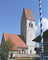
Church of St. Martin and Gasthaus zur Post in Egling

Church of St. Nikolaus in Deining
Neufahrn

Church in Thanning
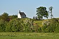
Chapel of St. Georg in Eulenschwang


Web links
- Local history in the archive portal of the Bad Tölz-Wolfratshausen district
- Entry on the coat of arms of Egling in the database of the House of Bavarian History
Individual evidence
- ↑ "Data 2" sheet, Statistical Report A1200C 202041 Population of the municipalities, districts and administrative districts 1st quarter 2020 (population based on the 2011 census) ( help ).
- ^ Community Egling in the local database of the Bavarian State Library Online . Bayerische Staatsbibliothek, accessed on September 6, 2019.
- ↑ Ingrid Bloss-Mannal, Helga Heubach, Petra Hübner: Free State of Bavaria, Administrative Region Upper Bavaria, Global-Verlag, 1985, p. 11147 [1]
- ^ Federal Statistical Office (ed.): Historical municipality directory for the Federal Republic of Germany. Name, border and key number changes in municipalities, counties and administrative districts from May 27, 1970 to December 31, 1982 . W. Kohlhammer, Stuttgart / Mainz 1983, ISBN 3-17-003263-1 , p. 568 .
- ↑ Announcement of the community of March 26, 2020
Attenham | Aufhofen | Aumühle | Bullreuth | Deining | Dettenhausen | Dürnstein | Egling | Endlhausen | Ergertshausen | Owl's Swing | Feldkirchen | Geilertshausen | Gold furnace | Harmating | Chert | Moosham | Neufahrn | Neukolbing | Oberegling | Oehnböck | Puppling | Reichertshausen | Riedhof | Sachsenhausen | Sawmill | Schalkofen | Schoenberg | Siegertshofen | Sonnenham | Thanning | Weihermühle | Worschhausen

Cities: Bad Tölz | Geretsried | Wolfratshausen
Municipalities: Bad Heilbrunn | Benediktbeuern | Bichl | Dietramszell | Egling | Eurasburg | Gaissach | Greiling | Icking | Jachenau | Kochel am See | Königsdorf | Lenggries | Münsing | Reichersbeuern | Sachsenkam | Schlehdorf | Wackersberg
Unregulated areas in the Bad Tölz-Wolfratshausen district of
Pupplinger Au |
Wolfratshauser Forest