
Sachsenkam
| coat of arms | Germany map | |
|---|---|---|

|
Coordinates: 47 ° 48 ' N , 11 ° 39' E |
|
| Basic data | ||
| State : | Bavaria | |
| Administrative region : | Upper Bavaria | |
| County : | Bad Toelz-Wolfratshausen | |
| Management Community : | Reichersbeuern | |
| Height : | 713 m above sea level NHN | |
| Area : | 15.93 km 2 | |
| Residents: | 1288 (Dec. 31, 2019) | |
| Population density : | 81 inhabitants per km 2 | |
| Postal code : | 83679 | |
| Area code : | 08021 | |
| License plate : | TÖL, WOR | |
| Community key : | 09 1 73 141 | |
| LOCODE : | DE OU6 | |
| Community structure: | 2 parts of the community | |
| Address of the municipal administration: |
Schulweg 7 83679 Sachsenkam |
|
| Website : | ||
| Mayor : | Andreas Rammler (independent electorate) | |
| Location of the municipality of Sachsenkam in the Bad Tölz-Wolfratshausen district | ||
  |
||

Sachsenkam is a municipality in the Upper Bavarian district of Bad Tölz-Wolfratshausen and a member of the Reichersbeuern administrative community . It is a popular destination.
geography
The community area is divided as follows:
- Buildings and open spaces: 23.26 ha
- Land owned by the municipality of Sachsenkam: 63.40 ha
- Plant area: 0.65 ha
- Recreational areas: 2.95 ha
- Traffic areas: 43.29 ha
- Agricultural land (with bog): 954.75 ha
- Forest: 506.64 ha
- Water: 59.91 ha
- Other areas 0.61 ha
Sachsenkam has two officially named municipal parts :
- Reutberg (monastery)
- Sachsenkam ( parish village )
history
Sachsenkam was probably founded as part of Charlemagne's settlement measures in the 8th or 9th century. The name suggests settlers from Saxony or a local founder named Sahso or similar. A document from 1035 shows that it belonged to the Tegernsee monastery early on , and later the place belonged to Count Adalbero von Ebersberg . The coat of arms of those of Ingram , to whom the village fell, has been the municipal coat of arms since 1959. Towards the end of the 15th century, the Tölz nurse Kaspar Winzerer acquired the Hofmark Sachsenkam; thereafter the place changes hands several times. When the Hofmark was abolished in 1848, the village was owned by von Sigriz.
Anna von Pinzenau received the place as a dowry in 1589 and laid the foundation stone for a Loreto chapel in 1606 , which was expanded when it could no longer accommodate the growing flow of pilgrims. In 1735, work on the church and monastery was completed in its current form. The monastery, attached to the Bavarian Franciscan Province since 1651 , has been running a famous pharmacy since 1668 . The brewery, which today continues as a brewery cooperative, dates from the same period. From 1837 to 1958 the monastery ran a girls' school, and to this day it runs a guesthouse. The nuns themselves also do a large part of the work that occurs in the farm belonging to the monastery.
Before the municipal reform , the municipality belonged to the old Bad Tölz district .
Population development
Between 1988 and 2018, the municipality grew from 807 to 1,315 by 508 inhabitants or 63% - the highest percentage increase in the district in the period mentioned.
politics
Municipal council
After the local elections on March 16, 2014 , the local council has twelve members, all of whom belong to the CSU / Independent faction . Belong to the electorate . The turnout was 60.85 percent. Another member and chairman of the municipal council is the 1st mayor Andreas Rammler.
coat of arms
The description of the coat of arms reads: In red a silver deer pole.
Culture and landscape
Attractions
- The nature reserve Ellbach- and Kirchseemoor with the Kirchsee (already placed under protection in 1940).
- The Reutberg Monastery, visible from afar, on a hilltop, with its church , brewery and the associated Bräustüberl with beer garden .
Because of the extraordinary landscape, Sachsenkam has been filming for film and television productions since the late 1960s, for example for Der Bulle von Tölz , Forsthaus Falkenau and Die Rosenheim-Cops . Crime scene commissioner Horst Schimanski has already "fallen" into the Kirchsee.
Architectural monuments
Soil monuments

Parish Church of St. Andrew
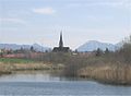
Sachsenkam with Mühlweiher

Kirchsee with Reutberg Monastery


Web links
- Entry on the coat of arms of Sachsenkam in the database of the House of Bavarian History
Individual evidence
- ↑ "Data 2" sheet, Statistical Report A1200C 202041 Population of the municipalities, districts and administrative districts 1st quarter 2020 (population based on the 2011 census) ( help ).
- ^ Community Sachsenkam in the local database of the Bavarian State Library Online . Bayerische Staatsbibliothek, accessed on September 6, 2019.
- ↑ Local history. In: sachsenkam.de. Municipality of Sachsenkam, accessed on May 12, 2019 .
- ↑ Description. In: sachsenkam.de. Municipality of Sachsenkam, accessed on May 12, 2019 .

Cities: Bad Tölz | Geretsried | Wolfratshausen
Municipalities: Bad Heilbrunn | Benediktbeuern | Bichl | Dietramszell | Egling | Eurasburg | Gaissach | Greiling | Icking | Jachenau | Kochel am See | Königsdorf | Lenggries | Münsing | Reichersbeuern | Sachsenkam | Schlehdorf | Wackersberg
Unregulated areas in the Bad Tölz-Wolfratshausen district of
Pupplinger Au |
Wolfratshauser Forest