Münsing
| coat of arms | Germany map | |
|---|---|---|

|
Coordinates: 47 ° 54 ' N , 11 ° 22' E |
|
| Basic data | ||
| State : | Bavaria | |
| Administrative region : | Upper Bavaria | |
| County : | Bad Toelz-Wolfratshausen | |
| Height : | 666 m above sea level NHN | |
| Area : | 52.23 km 2 | |
| Residents: | 4277 (Dec. 31, 2019) | |
| Population density : | 82 inhabitants per km 2 | |
| Postal code : | 82541 | |
| Primaries : | 08177, 08171, 08801 | |
| License plate : | TÖL, WOR | |
| Community key : | 09 1 73 137 | |
| LOCODE : | DE MUQ | |
| Community structure: | 24 parts of the community | |
| Address of the municipal administration: |
Weipertshausener Strasse 5 82541 Münsing |
|
| Website : | ||
| Mayor : | Michael Grasl ( FW ) | |
| Location of the community Münsing in the Bad Tölz-Wolfratshausen district | ||
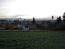
Münsing is a municipality in the Upper Bavarian district of Bad Tölz-Wolfratshausen on Lake Starnberg . Its municipal area extends from the shore of Lake Starnberg to the Münsinger Ridge, which rises between the lake and the Isar valley , and also includes the western Tischberg , which forms the southern crest of the ridge.
Parish parts
The municipality has 24 officially named municipal parts (the type of settlement is given in brackets ):
|
|
|
history
Until the church is planted
Münsing was founded around 550 by an elder named "Munigis". In the course of time the name changed via Munigisingen to the current name. Münsing was later part of the closed Hofmark Ammerland of the Counts of Baumgarten. The municipality became an independent political municipality in 1818 as part of the administrative reforms in the Kingdom of Bavaria .
Incorporations
On May 1, 1978, the previously independent community of Holzhausen am Starnberger See and part of the dissolved community of Degerndorf were incorporated.
Population development
Between 1988 and 2018, the community grew from 3,440 to 4,291 by 851 inhabitants or 24.7%.
politics
Municipal council
After the last local election on March 16, 2014 , the local council has 17 members. The turnout was 62.4%. The choice brought the following result:

mayor
Michael Grasl has been the mayor since April 2005. In the last election in March 2014, he received 91.4% of the vote.
coat of arms
The description of the coat of arms reads: Divided over silver waves of red and blue, on top of each other a golden heraldic lily and diagonally crossed a golden key and a golden sword.
Economy and Infrastructure
traffic
There is no train station in the community today. In the Degerndorf district there was a train station of the former Isar Valley Railway from Munich to Bichl until 1972 . The A 95 runs near Münsing and offers a quick connection to Munich . There is a landing stage for the Bayerische Seenschifffahrt in Ambach. There are also buses to Starnberg, Wolfratshausen and Seeshaupt.
Educational institutions
In addition to a primary school in Münsing, there are also three kindergartens in the municipality, which are located in Holzhausen (church), Degerndorf (communal) and Ammerland (private).
Culture and sights
Buildings
- Seeburg Castle in the Weipertshausen district
- Ammerland Castle
- Weidenkam Castle
- Hungarian gate
- Oberambach Castle Estate
- Parish Church of the Assumption
Regular events
The Münsinger ox race traditionally takes place in Münsing every four years, most recently in 2016 .
Every year a maypole is set up in a district of Münsing (Münsing-West, Münsing-Ost, Ammerland) and the other villages in the municipality (Holzhausen and Degerndorf). In 2009 the maypole was rebuilt in Münsing-Ost and Degerndorf.
Soil monuments
Personalities
- Waldemar Bonsels (born February 21, 1880 in Ahrensburg , † July 31, 1952 in Ambach), writer
- Thomas Darchinger (born May 5, 1963 in Neuburg / Donau), actor
- Heiner Lauterbach (born April 10, 1953 in Cologne), actor
- Franz Graf von Pocci (1807 † 1876), owner of Ammerland Palace
- Barbara Rudnik (1958 † 2009), actress
- Manfred Schmidt (* 1913 † 1999 in Ambach), comic artist
Honorary citizen
- Vicco von Bülow ( Loriot ) (* 1923; † 2011 in Ammerland; honorary citizen since 1993)
Sons and daughters of the church
- Annamirl Bierbichler (* 1946 in Ambach, † 2005 in Penzberg ), actress
- Josef Bierbichler (* 1948 in Ambach), actor
- Martin E. Süskind (* 1944 in Ambach, † 2009 in Berlin ), journalist and author
- Patrick Süskind (* 1949 in Ambach), author
- Stephan Roeschlein (* 1888 in Münsing; † 1971 in Bad Kreuznach ), German optics designer
literature
- Maximilian Schmidt : The Fischerrosl from St. Heinrich. 2000 ISBN 3-935115-11-3
- Dirk Heisserer: waves: wind and village bandits: literary explorations on Lake Starnberg. 1996 ISBN 3-424-01242-4
- Festschrift 1200 years of Münsing. Münsing 1979
- Friedrich Schnell and Hans-Peter Uenze: Local and parish history of Münsing, 740–1400 , self-published 1966
- Alma Lanzinger and the Münsing community: Ammerland in the old days. Self published in 2005
- Chronik Münsing, Volume 1, parish descriptions, family books and cadastral maps - sources on the Münsings, Holzhausens, Höhenrains and Degerndorfs families from the 18th to the 20th century , edited by Johannes Bernwieser and Sarah Ewerling on behalf of the Münsing community, Ambacher Verlag, 2013 , ISBN 978-3-9816330-0-9
- Chronik Münsing series, Volume 2, The village of Münsing from 1900 to 2000 in pictures, stories and memories - a citizens' project , published by Johannes Bernwieser on behalf of the Münsing community, Ambacher Verlag, 2013, ISBN 978-3-9816330-3-0
- Dorf & See - The community of Münsing in old views . The most beautiful motifs from the historical postcard collection of the Münsing community, Ambacher Verlag, 2016, ISBN 978-3-9816330-5-4
- See & Dorf - The east bank of Münsingen in historical pictures and photographs. The second volume with motifs from the postcard collection of the Münsing community, Ambacher Verlag, 2017, ISBN 978-3-9816330-6-1
Web links
- Website of the Münsing community
- Local history in the archive portal of the Bad Tölz-Wolfratshausen district
- Energiewende Münsing - pilot community for renewable energies of the community foundation Energiewende Oberland
- Entry on the Münsing coat of arms in the database of the House of Bavarian History
Individual evidence
- ↑ "Data 2" sheet, Statistical Report A1200C 202041 Population of the municipalities, districts and administrative districts 1st quarter 2020 (population based on the 2011 census) ( help ).
- ^ Münsing community in the local database of the Bavarian State Library Online . Bayerische Staatsbibliothek, accessed on September 6, 2019.
- ^ Federal Statistical Office (ed.): Historical municipality directory for the Federal Republic of Germany. Name, border and key number changes in municipalities, counties and administrative districts from May 27, 1970 to December 31, 1982 . W. Kohlhammer, Stuttgart / Mainz 1983, ISBN 3-17-003263-1 , p. 568 .
- ↑ https://www.wahlen.bayern.de/kommunalwahlen/


