
Bad Wiessee
| coat of arms | Germany map | |
|---|---|---|

|
Coordinates: 47 ° 43 ' N , 11 ° 43' E |
|
| Basic data | ||
| State : | Bavaria | |
| Administrative region : | Upper Bavaria | |
| County : | Miesbach | |
| Height : | 740 m above sea level NHN | |
| Area : | 32.79 km 2 | |
| Residents: | 5095 (Dec. 31, 2019) | |
| Population density : | 155 inhabitants per km 2 | |
| Postal code : | 83707 | |
| Area code : | 08022 | |
| License plate : | MB | |
| Community key : | 09 1 82 111 | |
| LOCODE : | DE BH8 | |
| Community structure: | 8 parts of the community | |
| Address of the municipal administration: |
Sanktjohanserstraße 12 83707 Bad Wiessee |
|
| Website : | ||
| Mayor : | Robert Kühn ( SPD ) | |
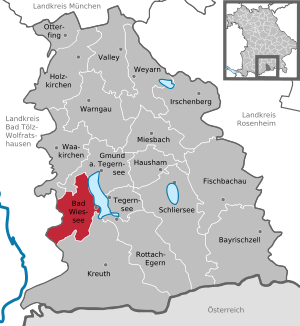
| Location of the municipality of Bad Wiessee in the Miesbach district | ||
  |
||


Bad Wiessee is a municipality in the Upper Bavarian district of Miesbach with around 5095 inhabitants. The holiday resort, a recognized health resort since 1922 , is located on the west bank of the Tegernsee in the Bavarian Oberland and borders the Bad Tölz-Wolfratshausen district . Bad Wiessee owes its rating as a spa to the two strongest iodine-sulfur mineral springs in Germany, which were discovered in 1909 during oil drilling. Since 1957, the operating casinos Bayern the Casino Bad Wiessee, which lies in the district since Winner of 2005.
Bad Wiessee was first mentioned in a document in 1017 in the land register of the Tegernsee monastery , when the Wesses Curia ( Hof von Wiessee ) had to pay various goods to the monastery.
geography

location
The community lies at an altitude of 735 to 1595 m above sea level. NHN on the west bank of the Tegernsee on the northern edge of the Bavarian Alps . The cities of Bad Tölz , Holzkirchen and Miesbach are 15–20 km away, the state capital Munich around 50 km. The closest train station is in Gmund am Tegernsee .
Community structure

There are eight officially named municipal parts (the type of settlement is given in brackets ):
|
Neighboring communities
The place borders in the west on the neighboring communities Gaißach and Lenggries in the Bad Tölz-Wolfratshausen district . A contiguous forest area and a mountain range from the Luckenkopf over the Sattelkopf to Fockenstein and Ochsenkamp separate the communities from one another. There are hiking and cycling trails but no direct road connection between the communities. The neighboring municipality of Waakirchen borders Bad Wiessee in the north. The mountains Luckenkopf, Kogelkopf and the Streitmöser are located on the short section of the municipal boundary to Waakirchen. The northern municipal border to Gmund runs over the Holzeralm , along the Dürnbach to Hainzenhöhe and ends at the Bayersäg in the Holz district on the B 318 . There is a shipping connection to the city of Tegernsee in the east and the municipality of Rottach-Egern in the southeast. In the south, Bad Wiessee borders the Ringsee district of the Kreuth community .
Waters
Three of the six larger tributaries of the Tegernsee flow into Bad Wiessee. The northernmost is the Breitenbach , which has its source on the Breitenberg, just below the Huders at 1200 m. ü. NHN.

The Söllbach rises as Gurnbach below the Seekarkreuz in the municipality of Lenggries. It flows in the Söllbachtal along the Scheibenaualm, the Söllbachaualm and the Alm Bauer in der Au. It then crosses the Buch district and flows into the Tegernsee at Abwinkl. It drains the area north of the Hirschberg and east of the Fockenstein . The normal flow rate of the Söllbach is around 1 m³ / s. During the Alpine floods in 2005 it rose in the estuary to around 29 m³ / s. At the mouth in the Abwinkl district there is a fish hatchery belonging to the Upper Bavaria State Fisheries Association and a large public aquarium with local fish from the Tegernsee.
The Zeiselbach has its source below the Aueralm. It drains the area north of the Söllberg and has an average discharge rate of 0.2 m³ / s. It flows past the Wachselmoosalm, the Semmelberg and the Sonnenbichl. After crossing the Prinzenruhe district, it crosses the federal highway 318 in the center of the village and joins the Tegernsee east of Dourdanplatz. Despite the flood protection measures, on June 13, 2014, after heavy nocturnal rainfall, the entire town center and the main road were flooded due to a blockage on the bridge near the town hall. The flow rate of the Zeiselbach increased briefly to 9.58 m³ / s.
Other small brooks such as the Weidenbach, the Filzgraben, the Deierlgraben, the Mühlbach, the Heissenbach and the Hölzlgraben run in the municipality.
mountains
The following mountains are located in the municipality:
|
|
|
Alpine pastures

The following alpine pastures are located in the municipality:
- Neuhüttenalm , 1329 m above sea level NHN
- Auer Alm , 1271 m above sea level NHN
- Baumgartenalm, 1256 m above sea level NHN
- Wachselmoosalm, 1185 m above sea level NHN
- Winneralm, 1051 m above sea level NHN
- Scheibenaualm, 938 m above sea level NHN
- Söllbachaualm, 927 m above sea level NHN
- Bauer in der Au, 904 m above sea level. NHN
- Finneralm, 830 m above sea level NHN
geology
.jpg)
The subsoil of Bad Wiessee is very heterogeneous due to its location. In contrast to the east bank of the Tegernsee with its directly rising mountains, Bad Wiessee lies on a wide strip of land on the west bank. This strip of land was formed by extensive cones of debris from the mountain streams, which are now recognizable as shield-shaped elevations. The area from the district of Rohbogen to Holz is mainly composed of glacial moraine deposits from the Tegernsee glacier. These typical features of a glacier cover with glacier floor and with remains of a ground moraine also form the ground on the Sonnenbichl and on the former Prinzenruh ski slope. In contrast, the loose gravel soil in the districts of Alt-Wiessee and Abwinkl was mainly formed by sediments carried along by the Söllbach , which flows into the Tegernsee here. The Söllbachtal used to be blocked by the bank moraine of the Tegernsee glacier, today's Sillberg. The so-dammed Söllbach, formerly called Sillbach, deposited a layer of gravel about a hundred meters thick, which forms a leveling in the middle of the mountains. This high gravel plain extends to the confluence of the disc trench. The Alm Bauer in der Au , a previously popular excursion destination, is located in the middle of this plateau. Due to its steep gradient and the rapid flow rate, the Söllbach used to carry a considerable amount of gravel. Over time, the gravel deposits were pushed into the Tegernsee so far that the lake at the mouth of the Söllbach was severely narrowed to around one and a half kilometers.
Clearly visible on French Hill, the northern entrance Bad Wiessee, and also the water Point Hill takes the typical folded mountains flysch . This type of rock is one of the oldest soil formations in Bad Wiessee and dates from the Cretaceous period . Before the construction of the Catholic Church of the Assumption of Mary in 1926, there was a quarry on the Wasserpointhügel, as building blocks could easily be broken from the layered and fissured flysch.
Between the Zeiselbach, the Breitenbach and the Semmelberg, moorland was created over a layer of lake clay over time. When the construction of a new settlement "In den Filzn " began in 1948 , it became apparent that the moor was about five meters thick. It was located above a layer of sea clay several meters thick, which was created in a separate side basin of the Tegernsee. This basin is located behind a ridge that stretches from the cherry tree hill to the Freihauswinkl. Parts of this rain moor have been preserved to this day and can be found in the center of the community directly behind the foyer of the iodine-sulfur bath that was demolished in 2018.
nature
natural reserve
Bad Wiessee is located within the approximately 9273 hectare protected landscape area of the Tegernsee and the surrounding area , which was designated in 1956.

The Flysch Mountains near Bad Wiessee with an area of about 955 hectares and an altitude of about 1128 m above sea level. NHN have been included in the Natura 2000 network of the European Union as a site of community importance . Within this natural area of the Swabian-Upper Bavarian Prealps there are acidic beech forests , mixed forests with fir trees and cave-low moor formations on the edge of the Mangfall Mountains . The nature conservation significance of the natural area is that of the largest and most representative occurrence of the grove beech forest in the entire Bavarian Alps. The forest grove is a rush plant, which prefers moist meadows, moderately shady forests, especially acidic beech forests.
environmental issues
Bad Wiessee is a member of the special purpose association for waste water disposal at Tegernsee. The Zweckverband was founded in 1956 to build the circular sewer system around the Tegernsee and to maintain the bathing quality and ecology of the Tegernsee. The lake was heavily polluted by sewage in the 1950s and an ecological catastrophe loomed.
history
Place name
The name Wiessee goes back to the first mention of the place Wesses around 1017 in the land register of the Tegernsee monastery and means that it is a settlement west of the lake. "Wesses" is the last stage in the development of the name, which was "Wesse" from the 14th to 17th centuries. The letter "t" from Westsee had already been sanded off and gone. The “s” at the end of the name, the genitive form “West of the lake” also disappeared over time. In the traditional documents of the Tegernsee monastery from 1155 to 1242, the form of the place name is still unsteady. The first "Hof von Westsee" mentioned here can be seen as the original settlement of Bad Wiessee and as its namesake.
timeline
The first indications of a settlement on the west bank of the Tegernsee come from the 10th century. When the Tegernsee monastery was reopened as an imperial abbey in 978 after the Hungarian invasions , workshops were also set up in which handicrafts were carried out. Five stained glass windows of Augsburg Cathedral have been preserved from the monastery glassworks . According to a chronicle, the glassworks was "in the meadow, across the lake". In 1017 an agriculture on the west bank is mentioned for the first time in the land register of the monastery. 1155 a Dietpold von Westensee is mentioned as a witness in a monastery document.
- Late Middle Ages

According to legend, in 1441 a monk in St. Quirin on the east bank of the Tegernsee discovered a golden yellow strip in the lake, which came from a place on the west bank above which a natural oil well ( petroleum ) existed. In fact, the spring, which has long since dried up, and whose location can still be recognized today by a listed chapel on the Bad Wiessee golf course, has existed for ages. According to a plaque inside the chapel, the spring was first captured in 1430. After the stone oil from Tegernsee had therapeutic properties (e.g. for rubbing in), it soon became very popular as St. Quirin oil and drew pilgrims to the lake.
In 1471 the monastery had three fish ponds built in the area of today's Wiessee. In the Salbuch of 1480, Wiessee first becomes tangible as a village. The village center was on a hill of the alluvial cone south of the Zeiselbach, today's district of Alt-Wiessee . There are three farms, plus several dependent houses. The oldest surviving building is the Sperrhof , which is dendrochronologically dated to 1587–89; the year 1594 is carved over the door.
- Modern times
Around this center, the place developed slowly until the end of the 19th century. Away from the village center, there was initially only one farm on the slope between Zeisel and Breitenbach. Only in the second half of the 19th century were further courtyards built north of the Zeiselbach; in particular, two families moved there, whose farms burned down in the old town center.
Abwinkl in the south on the Söllbach and Holz in the north as settlements probably emerged around the same time as Wiessee, the farms in Buch and the farmer in the Au , which were also listed in 1480, are included in Abwinkl . The scattered settlement of wood was mentioned in a document as early as 1291. After the secularization of the monastery in 1803, Wiessee was constituted as a political municipality in 1804; In 1808 Abwinkl and Holz were added to the Wiessee community.
After the abolition of the monastery, the Tegernsee valley initially no longer played a major role. This changed when King Maximilian I bought the former monastery in 1817 and had it expanded into his summer palace. He had the region developed and from 1820 the first road was built around the lake, through which Wiessee was first connected in the south with Tegernsee.
- Discovery of the iodine-sulfur source

Inspired by the widespread technical use of crude oil from the end of the 19th century, the Dutch company Dordtsche Petroleum Maatschappij tried from 1904 to discover rich oil deposits at greater depths, which were found at a depth of around 500 m. The first Bavarian Petroleum Society was founded in 1907 and a further eleven oil wells were carried out in Bad Wiessee. Only three of the wells encountered oil. By 1912, the output had dropped so far that oil production was stopped. On May 27, 1909, the Dutchman Adriaan Stoop came across abundant thermal water while drilling on borehole III at a depth of 692 m . The intermittent source had an output of about 1600 l / min and a temperature of 21 degrees Celsius. Since no crude oil was found even when the bore was deepened to 714 m, the shaft was closed on September 18, 1909. Subsequent chemical studies showed that it is the strongest iodine - sulfur - thermal spring negotiated Germany.

Only in the following year did the Wiesse doctor Erwin von Dessauer (1861–1938) recognize its importance after the balneological evaluation of the spring. At his suggestion, the first Wiesse spring baths were administered in two wooden bath tubs on July 22, 1910. As early as 1911, the number of baths administered rose to around 2000 per year. This was followed by the construction of the first bathhouse with 12 cabins by Adriaan Stoop in 1912 after he had given up the search for oil in Bad Wiessee. The spring was named after King Ludwig III in 1914 . and the petroleum company changed its name to Jod-Schwefelbad Wiessee GmbH under the direction of André Simon Driessen (1880–1956). This laid the foundation for the ascent to the spa . On June 30, 1922, Wiessee was awarded the title “Bad” and Adriaan Stoop was made an honorary citizen of Bad Wiessee. In 1930 there was another drilling to open up the Queen Wilhelmina source and in 1978 the drilling and development of the Adrianus source.
- National Socialism

During the so-called Röhm Putsch in 1934, the SA leadership met in Bad Wiessee on a telephone order from Hitler. In the Pension Hanselbauer Ernst Röhm and his SA leaders were arrested by the SS in the presence of Hitler and some of them shot on the same day. Towards the end of the war, hospitals were set up for tens of thousands of wounded in Bad Wiessee and the entire Tegernsee valley because of the spa facilities and the tourist infrastructure. When the US troops approached , German soldiers of the Waffen-SS surrendered the village and the valley without a fight out of consideration for the injured and withdrew to the south and southwest.
The Reich Minister of War , Field Marshal Werner von Blomberg , who was forced to resign by Hitler because of a mesalliance in 1938 , lived during the war with his wife Erna (also known as Eva or Margarethe) Gruhn in a mountain house near Bad Wiessee, where he was arrested by the Americans in 1945.
- present
On September 8, 2012, the community was the organizer of a music festival that took place on the former casino area and was part of the Bayern 3 village festival . The music groups Bayern-3-Band , the group Donikkl and the Weißwürschtl , the pop-rock band Stereolove , the band Dick Brave and The Backbeats and the musician Stefan Dettl performed at the all-day festival . The music festival met with national media interest and was attended by around 20,000 people. The concert stage including the technology, lighting and sound system was provided by the radio broadcaster Bayern 3 . The association Mia gengan steil eV was founded by the managing director of the community for the purpose of organizing and coordinating the approximately 400 volunteer helpers . 44 people were injured during the event and seven injured were admitted to the Agatharied district hospital.
Population development

On December 31, 2019, the place had a total of 5095 inhabitants, which corresponds to about five percent of the population of the district of Miesbach . In the middle of the 19th century, Bad Wiessee was only sparsely populated with around 300 inhabitants. This changed at the beginning of the 20th century when the place had about 600 inhabitants and after the discovery of the iodine-sulfur thermal spring in the 1920s it rapidly developed into a well-known health resort in Germany. By 1950 the population roughly quadrupled and jumped to around 4,300 inhabitants. This trend did not continue, however, with the exception of the baby boomers in the 1960s and the subsequent pill break , the population growth was moderate.
Between 1988 and 2018 the community grew from 4,266 to 5,022 by 756 inhabitants or 17.7%.
politics
coat of arms
In the award of the coat of arms by the State Ministry of the Interior in 1951, the blazon reads :
- "In blue over two silver wavy bars a golden bowl lifted up by two golden hands, in the base of the shield a golden three-mountain "
The municipal coat of arms symbolizes the mountains, represented in the lower part by the Dreiberg, the location on the Tegernsee, represented by the two silver wave beams and the healing spring , represented by the golden bowl carried by two golden hands, which was the symbol of the Bad Kurverwaltung Bad even before the coat of arms was awarded Wiessee was. The tinging includes the colors silver, blue and gold of the Tegernsee monastery and the colors of the elements of the Wittelsbach family coat of arms .
The council of Bad Wiessee consists of twelve councilors and four councilors, who were elected for six years in the local elections on March 16, 2014 , and the mayor with voting rights. The turnout in Bad Wiessee, at 51.2%, was below the Bavarian-wide turnout at 59.7%. The following table shows the distribution of seats in the municipal council since 2002:
| choice | CSU | SPD | FWG | GREEN | Bad Wiessee citizens list | ranBW | total | voter turnout |
|---|---|---|---|---|---|---|---|---|
| 2020 | 9 | 4th | 3 | 3 | 1 | - | 20 seats | 54.8% |
| 2014 | 5 | 3 | 5 | - | - | 3 | 16 seats | 51.2% |
| 2008 | 8th | 3 | 5 | - | - | - | 16 seats | 62.1% |
| 2002 | 6th | 4th | 6th | - | - | - | 16 seats | 60.9% |
| Percentages rounded, ranBW is the citizen list RAN Bad Wiessee | ||||||||
mayor
In the last local elections on March 16, 2014 , Peter Höß from the Free Voting Community / Wiesseer Block voter group was re-elected as the first mayor . He is supported and represented by the second mayor Robert Huber (SPD), who was elected by the local council. In the local elections, Höss received 57.2% of the vote. His opponent Rolf Neresheimer from the ranBW citizens' list , which was founded at short notice in January 2014 , unexpectedly received 42.8% of the vote. There was a serious error in the counting of the election results because the election management mistakenly assigned the votes of one constituency to the other candidate. As a result, the election result was falsified by around 4% to the detriment of the opposing candidate.
Community finances

The new construction of the casino in the Winner district and the purchase of the iodine-sulfur bath area by the community are a burden on the community coffers, so that Bad Wiessee with 29.6 million euros in 2014 (31.6 million in 2013) is one of the highly indebted communities counts in Bavaria. This is offset by substantial real assets in the form of 184 community apartments and a reserve of 6.7 million euros in 2014. The municipality has reduced the debt burden in the past by selling land. With the reserves in 2014, the municipality was able to acquire a building that was necessary to accommodate asylum seekers. The future of the community should be based on the resurgence of the spa offers and the redesign of the spa district with a medical center and a hotel. The purchase of the iodine-sulfur bath area in 2011 by the municipality formed the basis for this.
Partnerships
.svg)
Bad Wiessee has a partnership with the municipality of Dourdan in the Essonne district in France . Dourdan has more than twice the population of Bad Wiessee and is about 45 km southwest of Paris. Dourdan was one of the first cities in France to realize the desire for reconciliation between Germany and France, which was formulated in the framework of the Élysée Treaty in 1963. The founding fathers of the partnership were the mayor of Wiesse at the time, Hans Völkner (1907–1964) and the vice-mayor Raymond Laubier, who met by chance in Alsace in 1962 and decided to establish a partnership. The partnership charter was signed on April 20, 1963. Annual meetings and reciprocal visits, a youth exchange organized by the Association Partnership Friends Dourdan and an exchange between community representatives underline the partnership. The centrally located Dourdanplatz in Bad Wiessee is named after the partner community.
economy
The Bad Wiessee household is mainly financed from income from income tax , casino tax, trade tax and tourism. Tourism is largely based on hotels, guest houses and private quarters.
Companies
The largest employer in the area is Medical Park AG with around 600 employees. In Bad Wiessee, it operates the three orthopedic clinics St. Hubertus in the Abwinkl district, the specialist clinic on Kirschbaumhügel and the private clinic on Kirschbaumhügel . The clinics are run by Thomas Wessinghage , a former German track and field athlete, and together have around 540 beds. Another local clinic is the Jägerwinkel private clinic on Tegernsee for internal medicine and orthopedics with around 100 beds.
Another major employer is Autohaus Kathan GmbH with around 100 employees and four branches in the Miesbach district . A local company with high turnover is the Bad Wiessee casino with gross gaming revenue of EUR 20.7 million in 2013. The Bad Wiessee budget received a proportion of EUR 2.7 million from the casino levy in 2013. In 2012, the casino tax was around 2.2 million euros.
Several large hotels have closed or are for sale since the 1990s.
In 2015, the Swiss Sports Medicine Excellence Group acquired around 18,000 m² from the iodine bath area, including the listed foyer, from the community. It is planning a mixed use of a facility for outpatient operations, a therapy and regeneration center and a hotel.
media
The monthly Bürgerbote Bad Wiessee is distributed to all households and can be accessed online. It is financed through advertising by companies and retailers based in the Tegernsee Valley. The community belongs to the circulation area of the daily newspaper Tegernseer Zeitung , a local edition of the Münchner Merkurs .
education

The community has three kindergartens, the Catholic Kindergarten Maria Himmelfahrt , the Bad Wiessee crèche of the Evangelical Church and, since 2016, the forest kindergarten Die Waldkraxler . The community has a double primary and secondary school with lunchtime supervision. The Tegernseer Tal secondary school is located in the neighboring community of Gmund at educational institutions up to the 10th grade . The Abitur can be obtained at the Tegernsee Gymnasium or the Holzkirchen Gymnasium a little further away . The next state vocational school can be found in Miesbach. For adult education, courses can be attended at the Bad Wiessee adult education center.
Transport and infrastructure
Road traffic
Bad Wiessee is connected to the A8 (junction Holzkirchen / AS-No. 97) via the federal road 318 . This is one of the main traffic arteries of Bad Wiessee and leads directly through the town center. The municipality operates municipal traffic monitoring.
Transportation
There is a connection to the neighboring communities of Gmund , Tegernsee , Rottach-Egern and Kreuth via two RVO ring lines and direct bus connections to Holzkirchen and Bad Tölz .
| line | designation | course |
|---|---|---|
| 9557 | Upper Bavaria bus | Tegernsee - Rottach-Egern - Weißach - Bad Wiessee - Gmund am Tegernsee - Waakirchen - Reichersbeuern - Bad Tölz |
| 9559 | Ring lines A & B | Tegernsee - Rottach-Egern - Weißach - Bad Wiessee - Gmund am Tegernsee |
| 9566 | School bus | Tegernsee - Rottach-Egern - Weißach - Bad Wiessee - Gmund am Tegernsee - Warngau - Holzkirchen |
Rail transport
The closest train station is in Gmund on the shaftlach – Tegernsee line , which is served by the Bavarian Oberlandbahn (BOB) with a connection via Holzkirchen to Munich .
shipping
Two round trip routes operated by the Bayerische Seenschifffahrt link the two landing stages in Bad Wiessee with the other lakeside communities.
Hiking trails

The Maximiliansweg, divided into 22 daily stages, crosses Bad Wiessee between the stage locations Lenggries and Tegernsee on the 13th stage day . The long-distance hiking trail leads from Lindau on Lake Constance along the German Alps to Berchtesgaden . Coming from Lenggries, it leads in the Bad Wiessee municipality via the Neuhüttenalm , the Aueralm and the Wachselmoosalm, over the Zwergelberg past the Sonnenbichl to Abwinkl to the ship landing stage of the same name. There, as a special feature of the hiking trail, the boat takes you to Tegernsee. The hiking trail mostly runs the same route as the European long-distance hiking trail E4 and was named after Maximilian II , King of Bavaria.
Infrastructure
The water supply was originally organized privately. To this day, the Abwinkl district has its own water supply, which is organized as an association. In 1980 there was also a private water supply for the two farms “in der Au” and a joint, private supply for Alt-Wiessee. The municipal water supply came into being in 1928, when the growth of the municipality no longer permitted individual supply. For this purpose, a spring was taken in the Söllbachtal and two underground water tanks were created on the slope above the village. The work was done in-house, each household had to provide a share. Expansions followed in 1934 and 1950. With the expansion of tourism, water consumption rose steadily, so that in 1956 and 1960 additional sources with heavy pouring were opened up in two further steps. Since then, the municipal area has been largely supplied from the Söllbachtal.
The regional electricity supplier is the Tegernsee electricity company.
The wastewater disposal is taken over by the waste water disposal association at Tegernsee, which operates the circular sewer system and the joint sewage treatment plant in the Louisenthal district of Gmund .
Culture and sights
Architectural monuments

In the list of monuments in Bad Wiessee , all listed monuments are listed according to the list of monuments of the Bavarian State Office for the Preservation of Monuments. Bad Wiessee has 39 monuments, including farmhouses, Einfirsthöfe and chapels from the 17th and 18th centuries as well as newer buildings that were built in the troubled times between the two world wars. Two particularly old troad boxes ( granaries ) are still preserved today, one of which dates back to the 16th and 17th centuries. Century; the other is dated 1647/48 and can be found on the village square in Alt-Wiessee.
building
The town center around the centrally located Lindenplatz and Dourdanplatz is characterized by the town hall, the Hotel Gasthof zur Post and the old post office; all three buildings are listed.

When the iodine-sulfur spring was discovered in 1909 and Bad Wiessee rapidly developed into a modern spa and bathing resort after the First World War, the old town hall no longer met the needs. In 1930, a new two-storey town hall planned by architect Hermann Lang was built on the foundations of the old parish hall . The typical homeland style with a gable roof and down-to-earth basic shape was retained and a clock tower was built on the roof in accordance with the bell towers of the former farmhouses. The southern facade is determined by the bay window and the balcony. The two pointed arches and the gable fresco on the east side underline the importance of the building. The interior is determined by the rooms for the municipal administration and party traffic on the ground floor and the mayor's and secretarial rooms and the conference room on the first floor. The opening ceremony by Mayor Leonhard Sanktjohanser (1878–1952) took place on May 16, 1931.

The Catholic parish church Maria Himmelfahrt was planned by the architect Rupert von Miller . On April 15, 1925, the foundation stone was laid on the Wasserpointhügel and on December 24 of the same year the four bells rang out from the church tower over the Tegernsee. The church was consecrated on October 10, 1926 by Cardinal Michael von Faulhaber . The church organ with two manuals, 29 registers and 2148 pipes was built in 1985 by the German organ building company Sandtner and replaced the original organ. On the north wall rises the approximately 60 meter high tower with a high, very pointed hood. In it hang the four bells that are tuned to the notes C, Eb, Gb and A flat. Together they weigh about 4450 kg and are consecrated to Saints Mary and Saints Joseph , John the Baptist and Leonhard .

At the foot of the Wasserpointhügel underneath the parish church is the monument erected in 1955 . This commemorates the fallen in the Oberland uprising of 1705 and the two world wars. Behind the granite stele on the floor there are stone tablets laid in a semicircle and standing memorial tablets with the names of the fallen.

The Evangelical Lutheran Church of Peace is located on the cherry tree hill and was designed by Bruno Biehler . The groundbreaking ceremony took place on May 26, 1935. The laying of the foundation stone with church consecration by senior church councilor Oscar Daumiller took place on June 30, 1935. The consecration of the four bells with a total weight of 3,173 kg and the tones B, F, D flat and A flat was carried out on June 12, 1936. The solemn inauguration service took place on June 20, 1937. The church has a total of about 400 seats. The church organ with 30 registers is located directly above the altar and was built in 1990 by Georg Jann .

After the Second World War, further settlement areas emerged in the north of Bad Wiessee and the number of inhabitants grew. The reopening of the iodine-sulfur bath also increased the number of annual spa guests and tourists. In 1958, in the northern part of Bad Wiessee, the St. Anton parish was separated from the Maria Himmelfahrt parish and the construction of the second Catholic church St. Antonius on Dr.-Scheid-Strasse began. Their patron saint is Saint Anthony of Padua , who was born around 1195 and was a Franciscan mendicant monk. The church was built by the architects Richard Berchtold from Munich and Walter Ehm from Germering and consecrated on April 19, 1959 by Josef Cardinal Wendel .
The St. Antonius Church is a simple and functional building and was originally intended as a summer church for spa guests. A large colorful rose window emphasizes the side of the altar and shows Jesus Christ as a lamb, surrounded by the twelve gates of the heavenly Jerusalem. In the massive tower on the south-east side are the four steel bells, cast by the Penner company from Passau and on its top a gold-plated bronze angel blows the Last Judgment.
Green spaces and recreation
In the Abwinkl district is the community's public spa park , where the annual club and forest festivals take place. Another spa park is located on the cherry tree hill with two pavilions and a small pond with a stream.

The two shipping piers, Abwinkl and town center, are located along the approximately 5 km long promenade . Right at the beginning of the promenade is the Aquadome, built in 2005, with a walk-in aquarium, which presents the native fish species of the Tegernsee in four show basins.
Halfway towards the center of the village, you come across the Louis Braille fragrance and touch garden , which was specially created for people with walking and visual impairments.

It includes more than 70 different plant species and a rock fountain surrounded by water plants. The information boards for the plants are written in Braille and black letters. A covered pavilion with the bust of Louis Braille commemorates the inventor of Braille. In the music pavilion on the lake shore , various spa concerts take place mainly in summer. A public WiFi hotspot installed here by the municipality since 2014 allows wireless access to the Internet. The listed foyer with concert and theater hall and the iodine-sulfur bath can be reached in the last third of the promenade. The end point is the Grieblinger lido and the marina with its boat docks.
Leisure and sports facilities
- Bad Wiessee has a bathing park that can be used all year round with several indoor and outdoor pools, four whirlpools, a sunbathing area and a spacious sauna area. There is also an outdoor pool and several bathing areas on the lake.
- An artificial ice rink in the Prinzenruh district enables ice hockey, curling and ice skating in winter.
- The ski center on the Sonnenbichlhang with its ski lifts and slopes is located in the Buch district.
- At the exit of Bad Wiessee in the district of Rohbogen there is an 18-hole golf course of the Tegernsee Golf Club.
- A commercially operated indoor play arena with over 2000 m² is aimed at both children and adults.
Regular events
- Club and forest festivals during the summer months in the Abwinkl spa park
- Lake festival with fireworks in August on the lake promenade
- Tegernsee valley Montgolfiade in the winter months
- Spa concerts in the iodine-sulfur bath, in the pavilion on the lake promenade and in the Gasthof zur Post
- Christmas market "Seeweihnacht" on the lake promenade and "Abwinkler Advent" in the spa gardens of Abwinkl
- Tegernsee Studiobühne - cabaret in the Gasthof zur Post
- Tegernseer Volkstheater - Theater in the Gasthof zur Post
- Christmas theater in the Freihaus Brenner
Personalities
Honorary citizen
- Egid Pauli († November 1, 1930), was a stone breaker and mayor from 1900 to 1919
- Adriaan Stoop (1856–1935), Dutch mining engineer and discoverer of the iodine-sulfur thermal spring, awarded in 1922
- André Simon Driessen (1880–1956), first director of Jod-Schwefelbad Wiessee GmbH, awarded April 17, 1950
- Leonhard Sanktjohanser (1878–1952) was a master baker and mayor from 1919 to 1933 and 1945–1948
- Johannes Gansler (1895–1969), first Catholic pastor from 1924 to 1969
- Hans Völkner (1907–1964), hotelier and mayor from 1948 to 1964
- Martin Schlatter (1910–1987), was a restaurateur and second mayor from 1966 to 1984
- Helmut Ludwig (1911–1979), third mayor from 1952 to 1966
- Paul Krones (1916–1994), Mayor from 1965 to 1984
- Otto Beisheim (1924–2013), founder of the Metro Group, awarded at the beginning of November 2005
- Hans Hamberger (1934–2013), Catholic pastor in Bad Wiessee from 1969 to 2005, bestowed in October 2005.
Sons and daughters of the church
- Toni Kinshofer (1934–1964), German mountaineer
- Florian Furtwängler (1935–1992), German film director
- Ilka von Boeselager (* 1944), German politician ( CDU )
- Michael Meisenberg (* 1944), German lawyer
- Gabriele von Ende (* 1944), German painter
- Franz Massinger (1944–2011), German pianist and professor for piano
- Helmut Dietl (1944–2015), German film director and screenwriter
- Uta Würfel (* 1944), German politician (FDP)
- Michael Ande (* 1944), German actor
- Norbert Wieselhuber (* 1949), German management consultant
Personalities who worked on site or who lived here
- Fritz von Miller (1840–1921), German ore caster , goldsmith and sculptor
- Rupert von Miller (1879–1951), German architect and sculptor
- Rudolf Strempel (1891–1981), German doctor for skin and venereal diseases, university professor in Homburg (Saar)
- Josef Fellner (1892–1957), German painter, lived and worked in Bad Wiessee
- Ludwig Marcuse (1894–1971), German philosopher and writer; † in Bad Wiessee
- Johannes Schauff (1902–1990), German politician and entrepreneur, spent the last years of his life here
- Franz Grothe (1908–1982), German composer and conductor, lived in Bad Wiessee since 1948, as an expression of the high esteem for his adopted home on Lake Tegernsee he was awarded the community medal, his grave is in the local cemetery.
- Bruno Balz (1902–1988), one of the most productive German text and hit poets , had lived here since the 1960s.
- Hans Carste (1909–1971), German composer and conductor, spent the last year of his life here; his grave is in the local cemetery
- Josef Ertl (1925–2000), German politician and Federal Minister for Food, Agriculture and Forests , lived in Bad Wiessee
- Trudel Hardieck (1905–1990), founder and director of the private clinic Der Jägerwinkel
- Klaudia Martini (* 1950), German politician and lawyer, since 2008 a councilor in Bad Wiessee
- Uli Hoeneß (* 1952), long-time president of FC Bayern Munich , lives in Bad Wiessee
Web links
- Homepage of the community
- Bad Wiessee tourism site
- Entry on the coat of arms of Bad Wiessee in the database of the House of Bavarian History
literature
- Hermine Kaiser: Chronicle of Bad Wiessee: after Dr. Lorenz Radlmaier from the beginning until 1954 . tape 1 . Bad Wiessee 2014, p. 400 (no ISBN, self-published).
- Hermine Kaiser: First Tegernsee reading book . Culture - history - Bavarian. 2nd Edition. Bad Wiessee 2004, p. 295 (no ISBN, self-published).
- Peter A. Cramer: The western Tegernsee valley: memories . Bad Wiessee 1999, ISBN 3-00-005225-9 , p. 93 (self-published).
- Peter A. Cramer: History of the Tegernsee Valley: A foray . 3. Edition. Bad Wiessee 1991, p. 245 (no ISBN, self-published).
Individual evidence
- ↑ a b sheet "Data 2", Statistical Report A1200C 202041 Population of the municipalities, districts and administrative districts 1st quarter 2020 (population based on the 2011 census) ( help ).
- ↑ Mayor. Bad Wiessee community, accessed on May 25, 2020 .
- ↑ As of December 31, 2019
- ↑ a b Bad Wiessee iodine sulfur bath - healing springs. Community of Bad Wiessee - Health Center Jod-Schwefelbad GmbH, accessed on March 1, 2015 .
- ↑ a b c d e f g h i j Hermine Kaiser: Chronicle of Wiessee . tape 1 . Bad Wiessee 2014 (self-published, no ISBN).
- ^ Community Bad Wiessee in the local database of the Bavarian State Library Online . Bavarian State Library, accessed on September 7, 2019.
- ↑ a b Aquadome. (No longer available online.) Bad Wiessee community, archived from the original on February 6, 2015 ; accessed on February 20, 2015 .
- ↑ Level in the Danube area: Bad Wiessee, Söllbach. Bavarian State Office for the Environment, accessed on March 19, 2015 .
- ↑ Level in the Danube area: Bad Wiessee, Zeiselbach. Bavarian State Office for the Environment, accessed on March 19, 2015 .
- ↑ Tegernsee Voice: Cleaning up after the Zeiselbach flood , June 13, 2014.
- ↑ Tegernsee voice Wiessees "unknown" torrent , March 22, 2016th
- ↑ a b Geoinformation portal of the Miesbach district. Miesbach district, accessed on March 6, 2016 .
- ^ Geotopes in the Miesbach district. Bavarian State Office for the Environment, accessed on March 7, 2015 .
- ↑ Peter A. Cramer: The happy valley - From the history of the Tegernsee valley . 3rd revised edition. Bad Wiessee 1991 (self-published, no ISBN).
- ↑ Twenty beds are empty. SPIEGEL ONLINE GmbH, July 6, 1955, accessed on March 6, 2015 .
- ^ Tegernsee voice: The last moor of Bad Wiessee and the controversial new Kathan building , June 2, 2011.
- ↑ Demolition of the iodine bath begins. Local Voice GmbH, accessed December 14, 2019 .
- ↑ NATURA 2000 area research online. Bavarian State Office for the Environment, accessed on March 7, 2015 .
- ↑ Wastewater Association Tegernseer Tal - History. Association for wastewater disposal at Tegernsee, accessed on March 7, 2015 .
- ^ Community of Bad Wiessee - chronology. Bad Wiessee municipality, accessed on March 1, 2015 .
- ↑ Hermine Kaiser: Local history of Bad Wiessee. In: Hans Halmbacher: The Tegernsee valley in historical pictures . Fuchs-Druck, Hausham 1980, pp. 373-444, 376.
- ↑ a b List of monuments for Bad Wiessee (PDF) at the Bavarian State Office for Monument Preservation
- ^ Wilhelm Volkert (ed.): Handbook of Bavarian offices, communities and courts 1799–1980 . CH Beck, Munich 1983, ISBN 3-406-09669-7 , p. 552 .
- ^ Tegernsee voice: The discovery of the iodine source , January 2, 2014.
- ↑ 45,000 experience the largest village festival of all time. (No longer available online.) Local voice, UG, September 9, 2012, archived from the original on December 14, 2014 ; accessed on March 7, 2015 .
- ↑ Record number of visitors at the Bayern 3-Dorffest. Münchener Zeitungs-Verlag, September 10, 2012, accessed on March 7, 2015 .
- ↑ Bayern3-Dorffest: This is how the party will go. Münchener Zeitungs-Verlag, September 6, 2012, accessed on March 7, 2015 .
- ↑ Bayern3 - village festival. Münchener Zeitungs-Verlag GmbH & Co.KG, accessed on March 7, 2015 .
- ↑ Village festival: 44 injured and fights. Münchener Zeitungs-Verlag GmbH & Co.KG, September 9, 2012, accessed on March 7, 2015 .
- ^ Tegernsee voice: The non-voter spreads out , March 18, 2014.
- ^ Voting group ranBW. RanBW citizen list, accessed on February 12, 2015 .
- ↑ Bad Wiessee municipality | Rathaus News |. Retrieved March 23, 2020 .
- ↑ Local elections in Bavaria on March 16, 2014. Bavarian State Office for Statistics and Data Processing, accessed on February 12, 2015 .
- ↑ Local elections in Bavaria in 2008. Bavarian State Office for Statistics and Data Processing, accessed on February 12, 2015 .
- ↑ Local elections in Bavaria 2002. Bavarian State Office for Statistics and Data Processing, accessed on February 12, 2015 .
- ↑ Local elections in Bavaria - First mayor and lord mayor in the municipalities belonging to the district. Bavarian State Office for Statistics, March 16, 2014, accessed on December 13, 2015 .
- ↑ Tegernsee voice: 84 voices cause displeasure , March 19, 2014.
- ↑ debt statistics town of Bad Wiessee, 1978-2017 Table: 71327-001z, Code: 09,182,111th Bavarian State Office for Statistics and Data Processing, accessed on September 7, 2019 .
- ^ Tegernsee voice: Bad Wiessee continues to sell properties , December 18, 2012.
- ^ Tegernsee voice: Free State must help out Bad Wiessee , March 13, 2014.
- ↑ Tegernsee Voice: Hope for the Badepark , February 20, 2015.
- ^ Tegernsee voice: Thun's torn master plan , February 24, 2015.
- ↑ Lively partnership between Wiessee and Dourdan. Münchener Zeitungs-Verlag GmbH & Co.KG, September 8, 2015, accessed on November 11, 2015 .
- ↑ Politically wanted partnership grew into lively friendship. Münchener Zeitungs-Verlag GmbH & Co.KG, April 5, 2009, accessed on November 12, 2015 .
- ↑ Medical Park on expansion course. Local voice UG, September 1, 2014, accessed on September 7, 2019 .
- ^ Clinics and sanatoriums in Bad Wiessee. www.my-tegernsee.de, accessed on September 7, 2019 .
- ↑ Kathan car dealership in Bad Wiessee. (No longer available online.) Local voice, UG, archived from the original on February 21, 2015 ; accessed on February 12, 2015 .
- ↑ Wiessee is on the drip in his casino. Local voice UG, July 13, 2014, accessed on September 7, 2019 .
- ↑ Swiss investor buys iodine bath area. Local Voice UG, September 18, 2015, accessed on September 7, 2019 .
- ↑ Bürgerbote Bad Wiessee. Bad Wiessee community, accessed on December 14, 2019 .
- ↑ Tegernsee voice: Forest kindergarten takes the last hurdle , November 22, 2015.
- ↑ Tegernsee voice: Flash yes, rip-off no , January 17, 2014.
- ↑ Line map of the Miesbach district. Regional traffic Upper Bavaria, accessed on June 10, 2015 .
- ↑ a b Bad Wiessee community - utility company. Bad Wiessee community, accessed on July 29, 2015 .
- ^ Anton Beil: The water supply of Bad Wiessee. In: Hans Halmbacher: The Tegernsee valley in historical pictures . Fuchs-Druck, Hausham 1980, pp. 405-407.
- ^ A b Hans Hamberger: Bad Wiessee - Maria Himmelfahrt and St. Antonius . Ed .: Catholic parish office Maria Himmelfahrt. Kunstverlag Peda, 2004, ISBN 3-89643-551-5 , p. 28 .
- ↑ Online project memorials to the fallen. Thilo C. Agthe, accessed February 20, 2015 .
- ↑ Two clinics grow together. Münchener Zeitungs-Verlag GmbH & Co.KG, accessed on February 20, 2015 .
- ↑ Accessible facilities. Bad Wiessee community, accessed on February 20, 2015 .
- ↑ Maxi Hartberger: Wiesseers slide through the winter again. In: tegernseerstimme.de. Retrieved February 17, 2019 .
- ↑ a b c d e f g h i Bergfriedhof Bad Wiessee: Information board and gravestones. commons.wikimedia.org, accessed November 7, 2015 .
- ↑ Granting honorary citizenship . In: Minutes of the municipal council meeting, Topic 4 . Decision book 1950. Bad Wiessee April 17, 1950.
- ^ Bad Wiessee mourns Hans Hamberger. Münchener Zeitungs-Verlag GmbH & Co.KG, December 17, 2013, accessed on February 20, 2015 .

Bad Wiessee | Bayrischzell | Fischbachau | Gmund am Tegernsee | Hausham | Wooden churches | Irschenberg | Kreuth | Miesbach | Otterfing | Rottach-Egern | Schliersee | Tegernsee | Valley | Waakirchen | Warngau | Weyarn