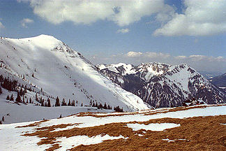
Mangfall Mountains
| Mangfall Mountains | ||
|---|---|---|
|
The summit of the Hirschberg , in the background the Kampen , Tegernsee mountains |
||
| Highest peak | Hinteres Sonnwendjoch ( 1986 m above sea level ) | |
| location | Bavaria (Germany) / Tyrol (Austria) | |
| part of |
Bavarian Prealps (AVE) Bavarian Alps (SOIUSA) |
|
| Classification according to | SOIUSA : 22.V | |
|
|
||
| Coordinates | 47 ° 36 ′ N , 11 ° 52 ′ E | |
| surface | 752.40 km² | |
The Mangfall Mountains are the easternmost part of the Bavarian Prealps , which in turn belong to the Northern Limestone Alps . It is named after the Mangfall , which drains large parts of the area via its tributaries Rottach, Weißach, Schlierach and Leitzach and forms an important drinking water reservoir for Munich .
geography
Geographical location
The mountain region is bounded in the west by the Isar valley and in the east by the Inntal , and in the south by the Brandenberg Alps (the Rofan). The foothills of the Alps join to the north of the Mangfall Mountains . The area has an area of 752.40 km².
The Mangfall Mountains are divided into the Tegernsee Mountains (from the Isar to the Tegernsee - Rottach - Weisse Valepp line ), Schlierseer Mountains (to the Leitzach Valley ) and the Wendelstein group (between Leitzach Valley , Original Valley and Inn Valley ).
summit
The highest peak of the Mangfall Mountains is the one in Tyrol, 1986 m above sea level. A. high rear Sonnwendjoch . The highest peak in Bavarian territory is the Rotwand at 1884 m above sea level. NN , one of the most popular local mountains for Munich residents in every season. The Wendelstein is located a few kilometers northeast of the Rotwand, but is separated from it by the Leitzach Valley. Brünnstein is a popular destination . Popular climbing peaks are the Ruchenköpf , Roßstein and Buchstein and the Plankenstein .
The following is a list of the most important peaks of the Mangfall Mountains, sorted by height in meters (m) above sea level (NN):
- Hinteres Sonnwendjoch (1,986 m), Kufstein District (Tyrol)
- Rotwand (1,884 m), Miesbach district
- Hochmiesing (1,883 m), Miesbach district
- Halserspitz (1,862 m), Miesbach district
- Großer Traithen (1,852 m), district of Rosenheim / district of Miesbach
- Wendelstein (1,838 m), Miesbach district / Rosenheim district
- Risserkogel (1,826 m), Miesbach district
- Schinder (1,808 m), Miesbach district
- Ruchenköpfe (1,805 m), Miesbach district
- Aiplspitz (1,759 m), Miesbach district
- Wallberg (1,722 m), Miesbach district
- Trainsjoch (1,708 m), Miesbach district
- Roßstein and Buchstein (1,698 m and 1701 m), Miesbach district
- Brecherspitz (1,683 m), Miesbach district
- Hirschberg (1,668 m), Miesbach district
- Brünnstein (1,619 m), Rosenheim district
- Schildenstein (1,613 m), Miesbach district
Lakes
Like the Alps as a whole, the Mangfall Mountains were also strongly influenced by the last Ice Age ( Würm Ice Age ). So z. B. lakes such as the Tegernsee or the Schliersee and the typical U-valleys through glaciers.
Development
The Mangfall Mountains are one of the longest-used parts of the Bavarian Alps. The oldest human artifacts in the German Alpine region were found in the area around the Rotwand . On the saddle between Tanzeck and Rauhkopf north of Rotwandhaus were two, just east of Soinsees a stone device as reading Fund discovered. Two of the cuts are made of radiolarite , one of flint , all of which are dated to Beuronia , the oldest phase of the Mesolithic . Further finds from the same period are known on the Austrian side near the Hinterer Sonnwendjoch and on both banks of the Achensee .
Ski areas
In the Mangfall Mountains there are two of the most important German ski areas: Sudelfeld and Spitzingsee . Further ski areas are located on Wendelstein , near Oberaudorf on Hocheck and on Hirschberg near Kreuth .
Huts
The Mangfall Mountains are accessed through a dense network of huts. Below is an overview of mountain huts with overnight accommodation:
- Aiblinger Hut ( DAV ), 1311m
- Brünnsteinhaus (DAV), 1342 m
- Kesselalm (private), 1278 m
- Albert Link Hut (DAV), 1053 m
- Obere Firstalm (private) 1370 m
- Buchsteinhütte (private) , 1240 m
- Lenggrieser Hut (DAV), 1338 m
- Blaubergalm (private), 1540 m
- Archduke Johann Klause (private), 814 m
- Alpine Club Hut Mitteralm (DAV), 1200 m
- Blecksteinhaus (DAV), 1022 m
- Forester's house Valepp (private), 872 m
- Rotwandhaus (DAV), 1737 m
- Soil cutting house (DAV), 1365 m
- Hirschberghaus (private), 1530 m
- Tegernseer Hütte (DAV), 1650 m
- Breitenberghaus ( friends of nature ), 1050 m
- Idealhanghütte (private), 1550 m
- Wallberghaus (private), 1512 m
- Schönfeldhütte (DAV), 1410 m
See also
Web links
Individual evidence
- ↑ Handbook of the natural spatial structure of Germany, first delivery. Edited on behalf of the Federal Office for Regional Studies and the Central Committee for German Regional Studies by E. Meynen and J. Schmithüsen, Remagen 1953, p. 72
- ↑ Peter Wischenbarth: First Mesolithic finds in the Mangfall Mountains (Upper Bavaria) . In: Bavarian prehistory sheets, year 66, 2001, pages 157–159


