
Great trait
| Great trait | ||
|---|---|---|
 Kleiner Unterberg (left), Unterberger Joch, Steilner Joch, Großer Traithen (far back) seen from the Brünnstein summit , in front of the Himmelmoos-Alm |
||
| height | 1852 m | |
| location | Kiefersfelden , district of Rosenheim , or Bayrischzell , district of Miesbach, Bavaria | |
| Mountains | Mangfall Mountains , Bavarian Prealps | |
| Dominance | 6.8 km → Dürrmiesing | |
| Notch height | 1016 m ↓ original pass | |
| Coordinates | 47 ° 38 '52 " N , 12 ° 2' 22" E | |
|
||
| rock | Plattenkalk | |
| Age of the rock | Triad | |

The Great Traithen is at 1852 m one of the higher mountains in the Mangfall Mountains . At the same time, it forms the highest peak in the Rosenheim district and is located in the municipality of Kiefersfelden and the area of the municipality of Bayrischzell in the Miesbach district not far from the Austrian city of Kufstein . Accordingly, the border between the districts of Rosenheim and Miesbach and the communities of Bayrischzell and Kiefersfelden runs at its summit.
Its western flank breaks off relatively steeply at around 1000 m into the original valley with the village of Bayrischzell , while the mountain leads north over the flat Fellalmsattel and the Kleiner Traithen to the Sudelfeld and to the east a ridge overgrown with pine trees over the Unterberger Joch and Steilner Joch (also called Steintraithen) sent to Brünnstein . The mountain can be climbed as a rather simple mountain hike that requires sure-footedness in places , from Sudelfeld, from Rosengasse, from Mühlau via Himmelmoosalm or up from the Ursprung valley.
There is a cross on the rocky summit, the panorama is extensive and extends in the south to the firn peaks of the central Alpine chain with the Großglockner , Großvenediger and Zillertal Alps . Particularly noteworthy is the view of the striking Kaiser Mountains and the Wendelstein in the north .

From left: Steilner Joch, Unterberger Joch, Großer Traithen, Kleiner Traithen, Sudelfeld; photographed from the Great Giant Head , i.e. from the north.

Großer Traithen, to the left of the Fellalmsattel the Kleine Traithen , further to the left the Vogelsang , on the right in the background the Kaiser Mountains , in the foreground the Soinalm
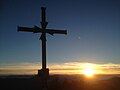
Sunset at the summit cross


Individual evidence
- ↑ Geological map of Bavaria with explanations (1: 500,000). Bavarian Geological State Office, 1998.