
Spitzingsee
| Spitzingsee | ||
|---|---|---|

|
||
| Geographical location | Schliersee Mountains | |
| Tributaries | Lochgraben, Firstgraben | |
| Drain | Rote Valepp → Valepp → Grundache → Brandenberger Ache → Inn | |
| Places on the shore | Spitzingsee | |
| Location close to the shore | Schliersee | |
| Data | ||
| Coordinates | 47 ° 39 '58 " N , 11 ° 53' 12" E | |
|
||
| Altitude above sea level | 1084 m above sea level NN | |
| surface | 28.3 ha | |
| length | 950 m | |
| width | 300 m | |
| volume | 2,049,000 m³ | |
| scope | 3.33 km | |
| Maximum depth | 16.3 m | |
| Middle deep | 7.2 m | |
| Catchment area | 7.51 km² | |

The Spitzingsee is a mountain lake in the Alps in southern Bavaria . The lake was also called "Stump See" on old maps. At the Spitzingsee lies the village of the same name, Spitzingsee .
location
The Spitzingsee is located about five kilometers south of the Schliersee and a few hundred meters south of the Spitzingsattels at an altitude of 1084 m in the Schlierseer Mountains , Mangfall Mountains , Bavarian Alps . With an area of 28.3 hectares (0.28 km²), it is one of the largest mountain lakes in Bavaria. The maximum depth of the lake is 16.3 meters (south basin). The north basin is up to 10.4 meters deep. The outflow is the Rote Valepp , which joins the White Valepp at the Kaiserklause (Forsthaus Valepp) and flows into the Inn in Tyrol as a Grundache and finally as the Brandenberger Ache . The Spitzingsee has a comparatively large water catchment area of 7.51 km².
The lake is owned by the Free State of Bavaria; the Bavarian Administration of State Palaces, Gardens and Lakes is responsible for its administration .
Locality
The place Spitzingsee on the lakeshore has about 200 inhabitants and belongs to the Schliersee market .
Surrounding mountains
The most famous peaks of the Mangfall Mountains around the Spitzingsee are Jägerkamp , Aiplspitz , Rauhkopf , Taubenstein , Rotwand ( 1884 m ), Ruchenköpf , Stolzenberg , Rotkopf , Roßkopf , Stümpfling , Bodenschneid and Brecherspitz .
The managed Alpine club houses in this region are the Schönfeldhütte , the Taubensteinhaus , the Rotwandhaus , the Blecksteinhaus , the Albert-Link-Hütte and the Bodenschneidhaus .
Ski and hiking area
The Spitzingsee ski area around the Stümpfling is located in the southwest of the lake. It can be reached by two chairlifts and a drag lift and offers numerous easy runs. Several million euros have been invested in modernization for several years. Two old double chairlifts were replaced by detachable quad chairlifts with weather protection hoods and a new children's lift was built; most of the slopes are artificially snowed. The Obere Firstalm and Brecherspitze lifts were dismantled.
Another area on the Taubenstein is in the east of the lake. The winter lift operation has now been discontinued, so that the area is only used by ski tourers. It is accessed by a gondola lift ( Taubensteinbahn ) from 1971, which continues to transport hikers outside of the ski season. There were some difficult slopes that were accessed by drag lifts. The valley run had a longer flat section with a slight counter-slope that could be shortened with a rope lift. A free shuttle bus ran between the valley stations every fifteen minutes during the main season. After decades of neglecting significant investments, this area offered the charm of skiing as it was back then . There was no artificial snow; operation in this area ended in February in some years. The valley run was then used by numerous ski tourers from the Rotwand area. In 2015 the operator announced the cessation of ski operations for economic reasons. In previous years, the ski area was only open on weekends and during school holidays. The Taubensteinbahn will continue to operate in summer.
Parking spaces are available free of charge at the curve lift, the Stümpflingbahn and the Taubensteinbahn (gondola). A 2.5 km long winter toboggan run also leads from the Upper Firstalm to the Spitzingsattel car park.
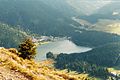
View from the Brecherspitz to the Spitzingsee

View towards Untere Firstalm

View over the Spitzingsattel to the Schliersee

View from the Rosskopf to the Spitzingsee


View from the village over the lake
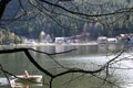
View over the lake to the village

Old root hut


